Point of interest nearby Facing smile
Iraq
Point of interest nearby Facing smile
Facing smile
6X5V+C67, Erbil, Erbil Governorate, Iraq
contacts phone
:
+964
Latitude:
36.2085323
, Longitude:
43.9930335
larger map & directions
read more
nearest Point of interest
171 m
سنتر اوبتيموم لطب الاسنان
6X4V+VG3, Erbil
Health
Point of interest
Establishment
Dentist
read more
280 m
مختار بختياري
6X4V+43H, شارع سوبر ماركت, Erbil
Post office
Finance
Point of interest
Establishment
read more
325 m
Sewar Gourmet
Bakhtiari 214/264, Erbil
Restaurant
Food
Point of interest
Establishment
read more
386 m
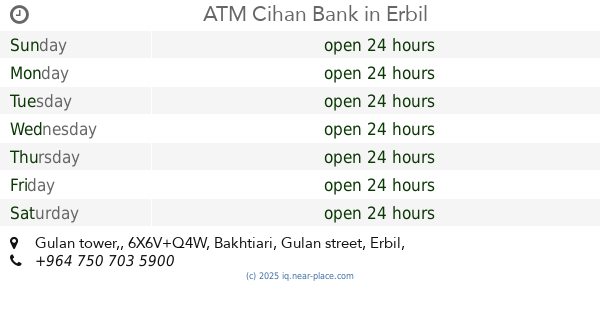
ATM Cihan Bank
6X6V+Q4W, Gulan tower,, Bakhtiari, Gulan street, Erbil
Atm
Finance
Point of interest
Establishment
read more
394 m
Erbil Branch
Gulan Street, UB Plaza, Bakhtiary, 48640, Erbil-Irak, Erbil 48640
Bank
Finance
Point of interest
Establishment
read more
484 m
Hardee's
Bakhtiari, Erbil
Restaurant
Food
Point of interest
Establishment
read more
546 m
Mawi Medical Center
6X4Q+585, Erbil
Establishment
Dentist
Beauty salon
Hair care
Health
Point of interest
Doctor
read more
600 m
European Dental Center
6X3R+8J5, Erbil
Health
Establishment
Point of interest
Dentist
read more
887 m
Somaria Bank
6232+748, Erbil
Bank
Finance
Point of interest
Establishment
read more
1.004 km
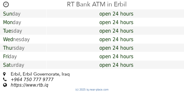
RT Bank ATM
Erbil
Atm
Finance
Point of interest
Establishment
read more
1.037 km
Dr. Zakaria Jamal Dental Clinic
opposite to ministry of justice, Ainkawa, Erbil
Dentist
Establishment
Point of interest
Health
read more
1.042 km
Emergency Management Center (EMC)
5XXW+WV9, 60 Meter Street, Erbil
Hospital
Health
Point of interest
Establishment
read more
1.087 km
RT Bank ATM
5XXX+V64, Erbil
Atm
Finance
Point of interest
Establishment
read more
1.136 km
Grand Istanbul
60th Street Bridge vs. Eankawa, Erbil
Lodging
Point of interest
Establishment
read more
1.162 km
ماركيت لينا
٦٠، اربيل،
Supermarket
Grocery or supermarket
Store
Food
Point of interest
Establishment
read more
📑
all categories
Accounting
Airport
Amusement park
Aquarium
Art gallery
Atm
Bakery
Bank
Bar
Beauty salon
Bicycle store
Book store
Bowling alley
Bus station
Cafe
Campground
Car dealer
Car rental
Car repair
Car wash
Casino
Cemetery
Church
City hall
Clothing store
Convenience store
Courthouse
Dentist
Department store
Doctor
Electrician
Electronics store
Embassy
Establishment
Finance
Fire station
Florist
Food
Funeral home
Furniture store
Gas station
General contractor
Grocery or supermarket
Gym
Hair care
Hardware store
Health
Hindu Temple
Home goods store
Hospital
Insurance agency
Jewelry store
Laundry
Lawyer
Library
Liquor store
Local government office
Locality
Locksmith
Lodging
Meal delivery
Meal takeaway
Mosque
Movie theater
Moving company
Museum
Neighborhood
Night club
Painter
Park
Parking
Pet store
Pharmacy
Physiotherapist
Place of worship
Plumber
Point of interest
Police
Political
Post office
Premise
Real estate agency
Restaurant
Roofing contractor
Route
Rv park, camping
School
Shoe store
Shopping mall
Spa
Stadium
Storage
Store
Sublocality
Supermarket
Synagogue
Taxi stand
Train station
Transit station
Travel agency
University
Veterinary care
Zoo
sublocality level 1
↑