Establishment nearby Mawi Medical Center
Iraq
Establishment nearby Mawi Medical Center
Mawi Medical Center
6X4Q+585, Erbil, Erbil Governorate, Iraq
contacts phone
:
+964 750 231 0832
Latitude:
36.2053949
, Longitude:
43.9883566
larger map & directions
read more
nearest Establishment
376 m
European Dental Center
6X3R+8J5, Erbil
Health
Establishment
Point of interest
Dentist
read more
401 m
مختار بختياري
6X4V+43H, شارع سوبر ماركت, Erbil
Post office
Finance
Point of interest
Establishment
read more
449 m
Erbil Branch
Gulan Street, UB Plaza, Bakhtiary, 48640, Erbil-Irak, Erbil 48640
Bank
Finance
Point of interest
Establishment
read more
527 m
سنتر اوبتيموم لطب الاسنان
6X4V+VG3, Erbil
Health
Point of interest
Establishment
Dentist
read more
546 m
Facing smile
6X5V+C67, Erbil
Dentist
Health
Point of interest
Establishment
read more
662 m
Sewar Gourmet
Bakhtiari 214/264, Erbil
Restaurant
Food
Point of interest
Establishment
read more
719 m
Alarabiya Islamic Bank
6X5J+HMM, Erbil
Bank
Finance
Point of interest
Establishment
read more
787 m
IDB-مصرف-التنمية-الدولي
6X7H+VVF, Erbil
Bank
Finance
Point of interest
Establishment
read more
846 m
Asti Jilamo Restaurant
40 Meter Street Main Gate of, Erbil
Restaurant
Point of interest
Food
Establishment
read more
893 m
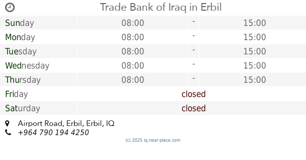
Trade Bank of Iraq
5XXR+3GW, Airport Road, Erbil
Bank
Finance
Point of interest
Establishment
read more
976 m
Sipan Hotel
Erbil
Lodging
Point of interest
Establishment
read more
976 m
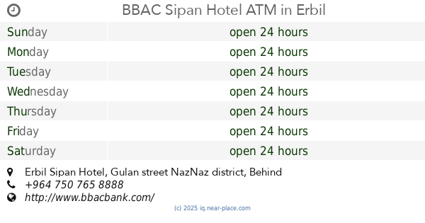
BBAC Sipan Hotel ATM
Erbil Sipan Hotel, Gulan street NazNaz district, Behind Park View Compound, Erbil
Atm
Finance
Point of interest
Establishment
read more
1.003 km
Hardee's
Bakhtiari, Erbil
Restaurant
Food
Point of interest
Establishment
read more
1.012 km
Emergency Management Center (EMC)
5XXW+WV9, 60 Meter Street, Erbil
Hospital
Health
Point of interest
Establishment
read more
1.081 km
RT Bank ATM
5XXX+V64, Erbil
Atm
Finance
Point of interest
Establishment
read more
📑
all categories
Accounting
Airport
Amusement park
Aquarium
Art gallery
Atm
Bakery
Bank
Bar
Beauty salon
Bicycle store
Book store
Bowling alley
Bus station
Cafe
Campground
Car dealer
Car rental
Car repair
Car wash
Casino
Cemetery
Church
City hall
Clothing store
Convenience store
Courthouse
Dentist
Department store
Doctor
Electrician
Electronics store
Embassy
Establishment
Finance
Fire station
Florist
Food
Funeral home
Furniture store
Gas station
General contractor
Grocery or supermarket
Gym
Hair care
Hardware store
Health
Hindu Temple
Home goods store
Hospital
Insurance agency
Jewelry store
Laundry
Lawyer
Library
Liquor store
Local government office
Locality
Locksmith
Lodging
Meal delivery
Meal takeaway
Mosque
Movie theater
Moving company
Museum
Neighborhood
Night club
Painter
Park
Parking
Pet store
Pharmacy
Physiotherapist
Place of worship
Plumber
Point of interest
Police
Political
Post office
Premise
Real estate agency
Restaurant
Roofing contractor
Route
Rv park, camping
School
Shoe store
Shopping mall
Spa
Stadium
Storage
Store
Sublocality
Supermarket
Synagogue
Taxi stand
Train station
Transit station
Travel agency
University
Veterinary care
Zoo
sublocality level 1
↑