Food nearby Restaurant gardens and palm breezes
Iraq
Food nearby Restaurant gardens and palm breezes
Restaurant gardens and palm breezes
Masafi Street, Baghdad, Al Rashid, IQ Iraq
contacts phone
:
+964 772 555 9518
website:
www.facebook.com
Latitude:
33.2599983
, Longitude:
44.4068183
larger map & directions
read more
nearest Food
595 m
Al-Yusur Market
7C35+XGH, Baghdad
Supermarket
Grocery or supermarket
Food
Point of interest
Store
Establishment
read more
2.669 km
Ovens Olives
6CP2+HH6, Unnamed Rd،, Baghdad
Bakery
Store
Food
Point of interest
Establishment
read more
2.809 km
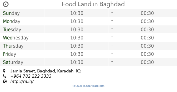
Food Land
79MV+276, Jamia Street, Baghdad
Restaurant
Point of interest
Food
Establishment
read more
2.822 km
Chili House
79JQ+9R4, Jamia Street, Baghdad
Restaurant
Food
Point of interest
Establishment
read more
2.934 km
AQUA CAFE IRAQ
79JP+7WV, Baghdad
Cafe
Point of interest
Food
Establishment
read more
2.945 km
مطعم باربكيو ستيشن
Baghdad
Meal takeaway
Restaurant
Food
Point of interest
Establishment
read more
2.995 km
كافتريا الفرات
سريع الدورة, بغداد
Meal takeaway
Restaurant
Food
Point of interest
Establishment
read more
3.599 km
Alwarda Market
7CR7+MX5, Baghdad
Supermarket
Grocery or supermarket
Food
Point of interest
Store
Establishment
read more
3.675 km
مثنى
69JP+FXH, الدوره
Meal takeaway
Restaurant
Point of interest
Food
Establishment
read more
3.918 km
Samun Zahra furnaces
69JJ+W7W, Baghdad
Bakery
Food
Point of interest
Store
Establishment
read more
4.249 km
الزيتون
7CWF+3W3, Baghdad
Restaurant
Food
Point of interest
Establishment
read more
4.264 km
Al_Tahoona bakery - arasat
7CVH+G9J, Baghdad
Bakery
Food
Point of interest
Store
Establishment
read more
4.465 km
Olive Branches Restaurant
مقابل جزيرة الاعراس, القادسية مجاور, Al Jadriyah Bridge, Baghdad
Restaurant
Food
Point of interest
Establishment
read more
5.717 km
Barley Restaurant - karada
Karada Kharidge, Baghdad
Restaurant
Food
Point of interest
Establishment
read more
5.843 km
مخبز الحارثية
893F+Q8P, Baghdad
Bakery
Point of interest
Store
Food
Establishment
read more
📑
all categories
Accounting
Airport
Amusement park
Aquarium
Art gallery
Atm
Bakery
Bank
Bar
Beauty salon
Bicycle store
Book store
Bowling alley
Bus station
Cafe
Campground
Car dealer
Car rental
Car repair
Car wash
Casino
Cemetery
Church
City hall
Clothing store
Convenience store
Courthouse
Dentist
Department store
Doctor
Electrician
Electronics store
Embassy
Establishment
Finance
Fire station
Florist
Food
Funeral home
Furniture store
Gas station
General contractor
Grocery or supermarket
Gym
Hair care
Hardware store
Health
Hindu Temple
Home goods store
Hospital
Insurance agency
Jewelry store
Laundry
Lawyer
Library
Liquor store
Local government office
Locality
Locksmith
Lodging
Meal delivery
Meal takeaway
Mosque
Movie theater
Moving company
Museum
Neighborhood
Night club
Painter
Park
Parking
Pet store
Pharmacy
Physiotherapist
Place of worship
Plumber
Point of interest
Police
Political
Post office
Premise
Real estate agency
Restaurant
Roofing contractor
Route
Rv park, camping
School
Shoe store
Shopping mall
Spa
Stadium
Storage
Store
Sublocality
Supermarket
Synagogue
Taxi stand
Train station
Transit station
Travel agency
University
Veterinary care
Zoo
sublocality level 1
↑