Food nearby Ovens Olives
Iraq
Food nearby Ovens Olives
Ovens Olives
Unnamed Rd،, 6CP2+HH6, Baghdad, Baghdad Governorate, Iraq
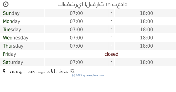
contacts phone
:
+964
Latitude:
33.2364227
, Longitude:
44.4013822
larger map & directions
read more
nearest Food
1.418 km
مثنى
69JP+FXH, الدوره
Meal takeaway
Restaurant
Point of interest
Food
Establishment
read more
1.977 km
Samun Zahra furnaces
69JJ+W7W, Baghdad
Bakery
Food
Point of interest
Store
Establishment
read more
2.172 km
Al-Yusur Market
7C35+XGH, Baghdad
Supermarket
Grocery or supermarket
Food
Point of interest
Store
Establishment
read more
2.669 km
Restaurant gardens and palm breezes
مجاور كلية الفارابي, Masafi Street, Baghdad
Restaurant
Point of interest
Food
Establishment
read more
2.733 km
Abu-Al'amba Restaurant
698P+856, Baghdad
Restaurant
Food
Point of interest
Establishment
read more
4.256 km
فولكينو برجر السيدية
Baghdad
Meal takeaway
Restaurant
Point of interest
Food
Establishment
read more
4.335 km
تجهيزات مشكور الغذائية
7925+76R, Baghdad
Meal delivery
Point of interest
Food
Establishment
read more
4.642 km
كافتريا الفرات
سريع الدورة, بغداد
Meal takeaway
Restaurant
Food
Point of interest
Establishment
read more
5.064 km
Chili House
79JQ+9R4, Jamia Street, Baghdad
Restaurant
Food
Point of interest
Establishment
read more
5.071 km
مطعم باربكيو ستيشن
Baghdad
Meal takeaway
Restaurant
Food
Point of interest
Establishment
read more
5.098 km
AQUA CAFE IRAQ
79JP+7WV, Baghdad
Cafe
Point of interest
Food
Establishment
read more
5.867 km
Olive Branches Restaurant
مقابل جزيرة الاعراس, القادسية مجاور, Al Jadriyah Bridge, Baghdad
Restaurant
Food
Point of interest
Establishment
read more
6.649 km
معطم فلافل علوش
شارع ابو مهدي المهندس, بغداد
Meal takeaway
Restaurant
Food
Point of interest
Establishment
read more
9.358 km
بيترعلي لعويني
8988+3CW, Baghdad
Bakery
Store
Food
Point of interest
Establishment
read more
15.545 km
طرشي البركه
87JH+RQC, شارع النفلة, Baghdad
Restaurant
Food
Point of interest
Establishment
read more
📑
all categories
Accounting
Airport
Amusement park
Aquarium
Art gallery
Atm
Bakery
Bank
Bar
Beauty salon
Bicycle store
Book store
Bowling alley
Bus station
Cafe
Campground
Car dealer
Car rental
Car repair
Car wash
Casino
Cemetery
Church
City hall
Clothing store
Convenience store
Courthouse
Dentist
Department store
Doctor
Electrician
Electronics store
Embassy
Establishment
Finance
Fire station
Florist
Food
Funeral home
Furniture store
Gas station
General contractor
Grocery or supermarket
Gym
Hair care
Hardware store
Health
Hindu Temple
Home goods store
Hospital
Insurance agency
Jewelry store
Laundry
Lawyer
Library
Liquor store
Local government office
Locality
Locksmith
Lodging
Meal delivery
Meal takeaway
Mosque
Movie theater
Moving company
Museum
Neighborhood
Night club
Painter
Park
Parking
Pet store
Pharmacy
Physiotherapist
Place of worship
Plumber
Point of interest
Police
Political
Post office
Premise
Real estate agency
Restaurant
Roofing contractor
Route
Rv park, camping
School
Shoe store
Shopping mall
Spa
Stadium
Storage
Store
Sublocality
Supermarket
Synagogue
Taxi stand
Train station
Transit station
Travel agency
University
Veterinary care
Zoo
sublocality level 1
↑