School nearby مركز عالم المعرفة
Iraq
School nearby مركز عالم المعرفة
مركز عالم المعرفة
7CV9+CV5, Baghdad, Baghdad Governorate, Iraq
contacts phone
:
+964 770 075 4026
website:
www.facebook.com
Latitude:
33.2935002
, Longitude:
44.4197397
larger map & directions
read more
nearest School
1.874 km
Al- Wehda secondary school
8C5H+8PP, Baghdad
School
Point of interest
Establishment
read more
2.218 km
اكاديمية بغداد للعلوم الأنسانية
8C5M+MR6, Baghdad
School
Point of interest
Establishment
read more
2.652 km
Al-Farah kindergarten and private school
8C2W+8Q7, Tariq Bin Ziao Street, Baghdad
School
Point of interest
Establishment
read more
2.767 km
الاعدادية النظامية للبنين
52 Wathiq Street, Baghdad
School
Point of interest
Establishment
read more
3.356 km
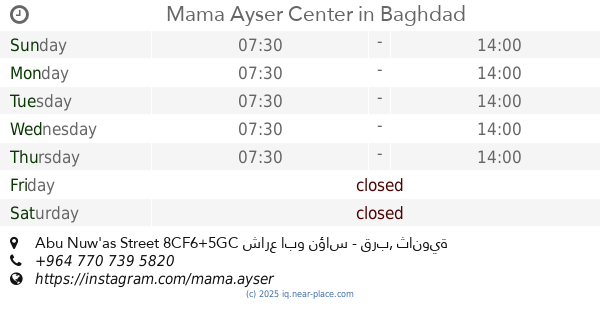
Mama Ayser Center
ثانوية العقيدة للبنات, Abu Nuw'as Street 8CF6+5GC شارع ابو نؤاس - قرب, Baghdad
School
Point of interest
Establishment
read more
3.447 km
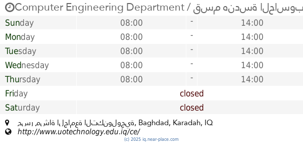
Computer Engineering Department / قسم هندسة الحاسوب
جسر مشاة الجامعة التكنولوجية, Baghdad
University
School
Point of interest
Establishment
read more
4.251 km
Dar Flowers Rivers Nursery
79HH+46C, Baghdad
School
Point of interest
Establishment
read more
4.576 km
مدرسة ابي سعيد الخدري
8CM5+94G, Baghdad
School
Point of interest
Establishment
read more
4.915 km
Al - Bawasel Primary School
8FH2+V3C, Baghdad
School
Point of interest
Establishment
read more
5.195 km
Bgahdad School of Music and Dance
899F+P7V, Damascus Street, Baghdad
School
Point of interest
Establishment
read more
5.249 km
Al Mutamayizeen Secondary
8968+4QG, Baghdad
School
Point of interest
Establishment
read more
5.259 km
Children's culture house
899C+6HJ, شارع دمشق, Baghdad
School
Point of interest
Establishment
read more
5.549 km
Al-Mansour Foundation Mixed School
8999+64V, Baghdad
School
Point of interest
Establishment
read more
5.608 km
Al Mansour High School for Boys
8988+RGH, Baghdad
School
Point of interest
Establishment
read more
13.505 km
Mohamed Tayeb average for boys
CF56+WM8
School
Point of interest
Establishment
read more
📑
all categories
Accounting
Airport
Amusement park
Aquarium
Art gallery
Atm
Bakery
Bank
Bar
Beauty salon
Bicycle store
Book store
Bowling alley
Bus station
Cafe
Campground
Car dealer
Car rental
Car repair
Car wash
Casino
Cemetery
Church
City hall
Clothing store
Convenience store
Courthouse
Dentist
Department store
Doctor
Electrician
Electronics store
Embassy
Establishment
Finance
Fire station
Florist
Food
Funeral home
Furniture store
Gas station
General contractor
Grocery or supermarket
Gym
Hair care
Hardware store
Health
Hindu Temple
Home goods store
Hospital
Insurance agency
Jewelry store
Laundry
Lawyer
Library
Liquor store
Local government office
Locality
Locksmith
Lodging
Meal delivery
Meal takeaway
Mosque
Movie theater
Moving company
Museum
Neighborhood
Night club
Painter
Park
Parking
Pet store
Pharmacy
Physiotherapist
Place of worship
Plumber
Point of interest
Police
Political
Post office
Premise
Real estate agency
Restaurant
Roofing contractor
Route
Rv park, camping
School
Shoe store
Shopping mall
Spa
Stadium
Storage
Store
Sublocality
Supermarket
Synagogue
Taxi stand
Train station
Transit station
Travel agency
University
Veterinary care
Zoo
sublocality level 1
↑