Point of interest nearby Mohamed Tayeb average for boys
Iraq
Point of interest nearby Mohamed Tayeb average for boys
Mohamed Tayeb average for boys
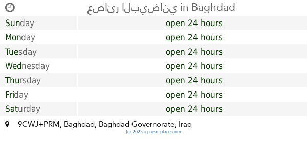
CF56+WM8, Baghdad, Baghdad Governorate, Iraq
contacts phone
:
+964
Latitude:
33.4097994
, Longitude:
44.4617164
larger map & directions
read more
nearest Point of interest
176 m
Maysan Elementary School for Boys
CF66+GC7, Baghdad
School
Point of interest
Establishment
read more
238 m
Mustafa Mosque
CF57+FHW
Mosque
Place of worship
Point of interest
Establishment
read more
1.286 km
سليم الخطاط
CF2C+MJ7
Painter
Point of interest
Establishment
read more
1.306 km
بيت أمحمد عاتي المرياني
CC5X+465, Baghdad
Campground
Lodging
Park
Point of interest
Establishment
read more
1.458 km
Sam Net Earth Tower Link Internet
CFF5+3HQ
Shopping mall
Point of interest
Establishment
read more
1.47 km
ملجأ قطاع 34
9FW5+PH8, Baghdad
Fire station
Point of interest
Establishment
read more
1.491 km
مختبرات سهى للتصوير
قطاع 44،
Movie theater
Point of interest
Establishment
read more
1.911 km
مكتب العراق للانترنت
9CWX+9RJ, Baghdad
Hindu Temple
Place of worship
Point of interest
Establishment
read more
1.928 km
الملجأ
9FWG+XGM, Baghdad
Hospital
Health
Point of interest
Establishment
read more
1.944 km
مكتب حيدر للحاسبات وخدمات الانترنيت وكيل شركة ايرث لنك
9FR6+WFG, Baghdad
Electronics store
Store
Point of interest
Establishment
read more
1.967 km
ملجأ قطاع ٤٨
9FWG+PC8, Fellah Street, Baghdad
Fire station
Point of interest
Establishment
read more
2.085 km
Hamidia Tower 4 Internet Services
CFH9+39H
Shopping mall
Point of interest
Establishment
read more
2.652 km
ابو علي للتاسيسات الصحية
9FP3+V2H, Baghdad
Plumber
Point of interest
Establishment
read more
2.895 km
Ali Younis Accessories
Baghdad
Shopping mall
Point of interest
Establishment
read more
3.105 km
عصائر البيضاني
9CWJ+PRM, Baghdad
Night club
Point of interest
Establishment
read more
📑
all categories
Accounting
Airport
Amusement park
Aquarium
Art gallery
Atm
Bakery
Bank
Bar
Beauty salon
Bicycle store
Book store
Bowling alley
Bus station
Cafe
Campground
Car dealer
Car rental
Car repair
Car wash
Casino
Cemetery
Church
City hall
Clothing store
Convenience store
Courthouse
Dentist
Department store
Doctor
Electrician
Electronics store
Embassy
Establishment
Finance
Fire station
Florist
Food
Funeral home
Furniture store
Gas station
General contractor
Grocery or supermarket
Gym
Hair care
Hardware store
Health
Hindu Temple
Home goods store
Hospital
Insurance agency
Jewelry store
Laundry
Lawyer
Library
Liquor store
Local government office
Locality
Locksmith
Lodging
Meal delivery
Meal takeaway
Mosque
Movie theater
Moving company
Museum
Neighborhood
Night club
Painter
Park
Parking
Pet store
Pharmacy
Physiotherapist
Place of worship
Plumber
Point of interest
Police
Political
Post office
Premise
Real estate agency
Restaurant
Roofing contractor
Route
Rv park, camping
School
Shoe store
Shopping mall
Spa
Stadium
Storage
Store
Sublocality
Supermarket
Synagogue
Taxi stand
Train station
Transit station
Travel agency
University
Veterinary care
Zoo
sublocality level 1
↑