Point of interest nearby محطة غسل المعلمين
Iraq
Point of interest nearby محطة غسل المعلمين
محطة غسل المعلمين
7G34+V5X, Baghdad, Baghdad Governorate, Iraq
contacts phone
:
+964
Latitude:
33.2547458
, Longitude:
44.5054958
larger map & directions
read more
nearest Point of interest
4 m
Rahman Library Stationery
7G34+W54, الزعفرانية سوق مريم, بغداد / الزعفرانية / سوق مريم / قرب مطعم ابو عكال
Library
Point of interest
Establishment
read more
489 m
The Technical Studio Photography
54, Baghdad
Movie theater
Point of interest
Establishment
read more
779 m
Technical Institute of Management
Baghdad
University
Point of interest
Establishment
read more
820 m
مغتسل المصطفى
7G66+3HM, Baghdad
Funeral home
Point of interest
Establishment
read more
990 m
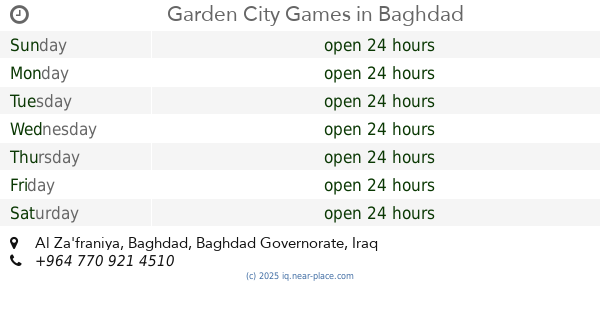
Garden City Games
Baghdad
Park
Amusement park
Point of interest
Establishment
read more
1.003 km
الجامعة التقنية الوسطى / معهد اعداد المدربين التقنيين
طريق معسكر الرشيد بغداد Al zafaraneh, Baghdad
University
Point of interest
Establishment
read more
1.139 km
Abn Jabor honey
6FWX+7W7, Baghdad
Shopping mall
Point of interest
Establishment
read more
1.282 km
مكتب الوطني للانترنت من ايرثلنك ( بادارة علي طارق )
6FXV+WH2, Baghdad
Synagogue
Place of worship
Point of interest
Establishment
read more
1.91 km
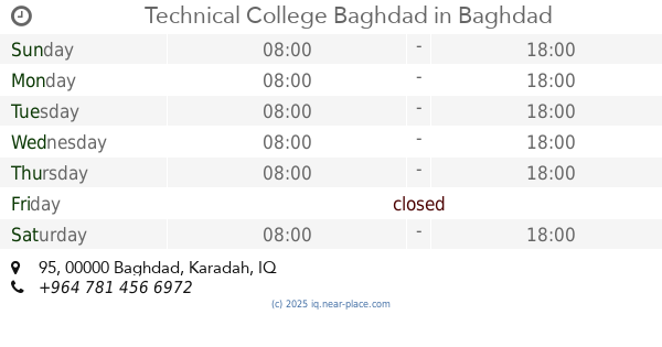
Technical College Baghdad
95, Baghdad
University
Point of interest
Establishment
read more
2.196 km
Municipal Council Zaafaraniah
7F6M+RCW, Baghdad
City hall
Local government office
Point of interest
Establishment
read more
2.309 km
Stadium altadamun
6FVM+HPF, Baghdad
Stadium
Point of interest
Establishment
read more
2.591 km
ركن الغيبة.
7F9M+G8C, Baghdad
Campground
Lodging
Park
Point of interest
Establishment
read more
3.123 km
صيدلية بحر الافكار
6GH9+MRV, Jisr Diyala
Pharmacy
Store
Health
Point of interest
Establishment
read more
3.142 km
Civil Defense Center in Diyala Bridge
6GH9+JVM, Jisr Diyala
Fire station
Point of interest
Establishment
read more
3.592 km
بيت بشير
6GHG+6WX, Jisr Diyala
Campground
Park
Lodging
Point of interest
Establishment
read more
📑
all categories
Accounting
Airport
Amusement park
Aquarium
Art gallery
Atm
Bakery
Bank
Bar
Beauty salon
Bicycle store
Book store
Bowling alley
Bus station
Cafe
Campground
Car dealer
Car rental
Car repair
Car wash
Casino
Cemetery
Church
City hall
Clothing store
Convenience store
Courthouse
Dentist
Department store
Doctor
Electrician
Electronics store
Embassy
Establishment
Finance
Fire station
Florist
Food
Funeral home
Furniture store
Gas station
General contractor
Grocery or supermarket
Gym
Hair care
Hardware store
Health
Hindu Temple
Home goods store
Hospital
Insurance agency
Jewelry store
Laundry
Lawyer
Library
Liquor store
Local government office
Locality
Locksmith
Lodging
Meal delivery
Meal takeaway
Mosque
Movie theater
Moving company
Museum
Neighborhood
Night club
Painter
Park
Parking
Pet store
Pharmacy
Physiotherapist
Place of worship
Plumber
Point of interest
Police
Political
Post office
Premise
Real estate agency
Restaurant
Roofing contractor
Route
Rv park, camping
School
Shoe store
Shopping mall
Spa
Stadium
Storage
Store
Sublocality
Supermarket
Synagogue
Taxi stand
Train station
Transit station
Travel agency
University
Veterinary care
Zoo
sublocality level 1
↑