Point of interest nearby الدفاع المدني
Iraq
Point of interest nearby الدفاع المدني
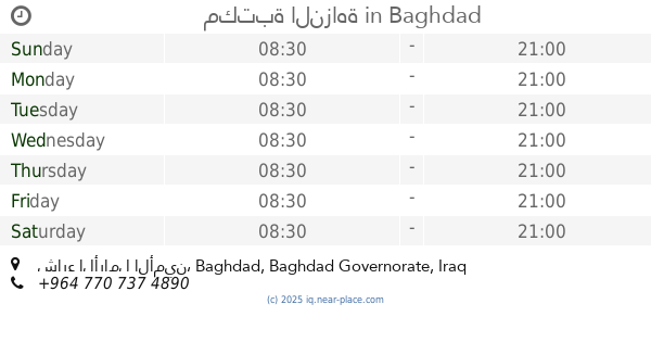
الدفاع المدني
Unnamed Road،،،، 8J37+GG6، القرية النفطية، Diyala Governorate, Iraq
contacts phone
:
+964
Latitude:
33.3037798
, Longitude:
44.6137632
larger map & directions
read more
nearest Point of interest
2.182 km
هاا
7JM5+V53, Baghdad
Synagogue
Place of worship
Point of interest
Establishment
read more
8.073 km
دلفري النهروان للتوصيل السريع
9M85+5V, Nahrawan
Meal delivery
Food
Point of interest
Establishment
read more
9.169 km
مكتبة النزاهة
الثانية, شارع الأرامل الأمين, Baghdad
Shopping mall
Point of interest
Establishment
read more
11.599 km
جاي كرار الركابي
8F4Q+2HP
Liquor store
Store
Point of interest
Establishment
read more
12.061 km
Civil Defense Center in Diyala Bridge
6GH9+JVM, Jisr Diyala
Fire station
Point of interest
Establishment
read more
12.191 km
محكمة كاتب العدل
8F6M+M5C, Baghdad
Local government office
Courthouse
Point of interest
Establishment
read more
12.344 km
ملعب الاصدقاء الرياضي
Baghdad
Stadium
Point of interest
Establishment
read more
12.736 km
ركن الغيبة.
7F9M+G8C, Baghdad
Campground
Lodging
Park
Point of interest
Establishment
read more
13.183 km
ورشة القاسم للتبريد
8F7C+WX5, Baghdad
Art gallery
Point of interest
Establishment
read more
14.871 km
شركة السهم الأزرق للخدمات الأمنية
كراج الاصدقاء, بغداد
Insurance agency
Point of interest
Establishment
read more
15 km
مونوبولينك-monobowling
شارع الربيعي, Baghdad
Bowling alley
Point of interest
Establishment
read more
15.057 km
Chili House and Lee's Famous Recipe Chicken
8FG3+PJ9, Al Rubaie Street, Baghdad
Restaurant
Food
Point of interest
Establishment
read more
16.071 km
النواب
9F63+2W2, Baghdad
Local government office
Courthouse
Point of interest
Establishment
read more
16.554 km
جامع التوبة
iraq , baghdad , aldora
Mosque
Place of worship
Point of interest
Establishment
read more
18.393 km
Mohamed Tayeb average for boys
CF56+WM8
School
Point of interest
Establishment
read more
📑
all categories
Accounting
Airport
Amusement park
Aquarium
Art gallery
Atm
Bakery
Bank
Bar
Beauty salon
Bicycle store
Book store
Bowling alley
Bus station
Cafe
Campground
Car dealer
Car rental
Car repair
Car wash
Casino
Cemetery
Church
City hall
Clothing store
Convenience store
Courthouse
Dentist
Department store
Doctor
Electrician
Electronics store
Embassy
Establishment
Finance
Fire station
Florist
Food
Funeral home
Furniture store
Gas station
General contractor
Grocery or supermarket
Gym
Hair care
Hardware store
Health
Hindu Temple
Home goods store
Hospital
Insurance agency
Jewelry store
Laundry
Lawyer
Library
Liquor store
Local government office
Locality
Locksmith
Lodging
Meal delivery
Meal takeaway
Mosque
Movie theater
Moving company
Museum
Neighborhood
Night club
Painter
Park
Parking
Pet store
Pharmacy
Physiotherapist
Place of worship
Plumber
Point of interest
Police
Political
Post office
Premise
Real estate agency
Restaurant
Roofing contractor
Route
Rv park, camping
School
Shoe store
Shopping mall
Spa
Stadium
Storage
Store
Sublocality
Supermarket
Synagogue
Taxi stand
Train station
Transit station
Travel agency
University
Veterinary care
Zoo
sublocality level 1
↑