Health nearby الدكتور محمود السيلاوي
Iraq
Health nearby الدكتور محمود السيلاوي
الدكتور محمود السيلاوي
H2X5+X62, Karbala, Karbala Governorate, 56001, Iraq
contacts phone
:
+964 780 124 3153
Latitude:
32.5998856
, Longitude:
44.0080096
larger map & directions
read more
nearest Health
130 m
برومو لطب الاسنان
J225+C4F, Karbala
Dentist
Health
Point of interest
Establishment
read more
356 m
عيادة الدكتور هشام الهر
مجاور مستشفى الحجة, كربلاء
Dentist
Health
Point of interest
Establishment
read more
577 m
بصمة لطب الاسنان
J236+GQP, Karbala
Dentist
Health
Point of interest
Establishment
read more
578 m
عيادة التحدي
H2W3+W2X, التحدي، كربلاء،, كربلاء
Dentist
Health
Point of interest
Establishment
read more
681 m
عيادة الملكة للأسنان د عبدالله ظاهر
Unnamed Road,، كربلاء 56001،
Dentist
Health
Point of interest
Establishment
read more
744 m
عيادة الدكتور خالد الاعرجي
H2V6+PV6, Karbala
Dentist
Health
Point of interest
Establishment
read more
882 m
مركز فاملي لطب الأسنان والتجميل
القاعة الرياضية المغلقة, Karbala'
Dentist
Health
Point of interest
Establishment
read more
1.03 km
IMORE Dental Clinic - عيادات آي مور لطب وتجميل الأسنان
مجاور مجمع العفاف, شارع حي الحسين, Karbala'
Dentist
Doctor
Health
Point of interest
Establishment
read more
1.133 km
العربي لطب الاسنان
J22C+R75, شارع السناتر, Karbala'
Hospital
Health
Point of interest
Establishment
read more
1.322 km
عيادة الدكتور احمد الموسوي
Unnamed Road, Karbala 56001،
Dentist
Health
Point of interest
Establishment
read more
1.513 km
د ايات
J24F+82M, Karbala
Dentist
Health
Point of interest
Establishment
read more
1.639 km
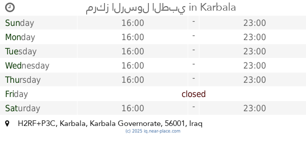
مركز الرسول الطبي
H2RF+P3C, Karbala
Hospital
Health
Point of interest
Establishment
read more
1.668 km
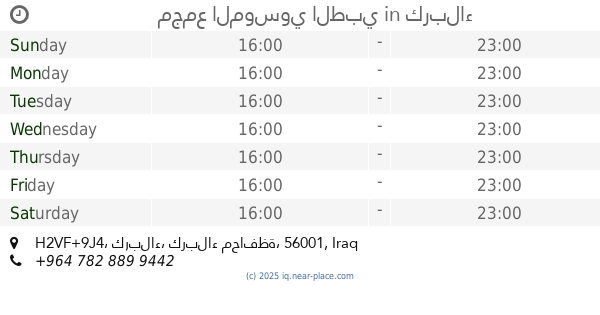
مجمع الموسوي الطبي
H2VF+9J4, كربلاء
Hospital
Health
Point of interest
Establishment
read more
1.677 km
مركز الرازي الطبي التخصصي
H2XG+C8Q, Al Ameer Ali St, Karbala
Hospital
Health
Point of interest
Establishment
read more
1.788 km
مجمع الابيض الطبي
H2VG+25F, Iskan Street, Karbala'
Hospital
Health
Point of interest
Establishment
read more
📑
all categories
Accounting
Airport
Amusement park
Aquarium
Art gallery
Atm
Bakery
Bank
Bar
Beauty salon
Bicycle store
Book store
Bowling alley
Bus station
Cafe
Campground
Car dealer
Car rental
Car repair
Car wash
Casino
Cemetery
Church
City hall
Clothing store
Convenience store
Courthouse
Dentist
Department store
Doctor
Electrician
Electronics store
Embassy
Establishment
Finance
Fire station
Florist
Food
Funeral home
Furniture store
Gas station
General contractor
Grocery or supermarket
Gym
Hair care
Hardware store
Health
Hindu Temple
Home goods store
Hospital
Insurance agency
Jewelry store
Laundry
Lawyer
Library
Liquor store
Local government office
Locality
Locksmith
Lodging
Meal delivery
Meal takeaway
Mosque
Movie theater
Moving company
Museum
Neighborhood
Night club
Painter
Park
Parking
Pet store
Pharmacy
Physiotherapist
Place of worship
Plumber
Point of interest
Police
Political
Post office
Premise
Real estate agency
Restaurant
Roofing contractor
Route
Rv park, camping
School
Shoe store
Shopping mall
Spa
Stadium
Storage
Store
Sublocality
Supermarket
Synagogue
Taxi stand
Train station
Transit station
Travel agency
University
Veterinary care
Zoo
sublocality level 1
↑