Hospital nearby العربي لطب الاسنان
Iraq
Hospital nearby العربي لطب الاسنان
العربي لطب الاسنان
شارع السناتر, 56001, Karbala', Karbala, IQ Iraq
contacts phone
:
+964 774 002 3700
Latitude:
32.6031647
, Longitude:
44.0194669
larger map & directions
read more
nearest Hospital
55 m
صيدلية فاطمة محمود حسين
J239+3VP, Karbala
Hospital
Health
Point of interest
Establishment
read more
652 m
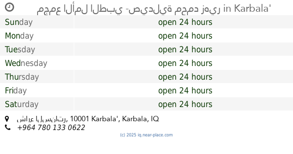
مجمع الأمل الطبي -صيدلية محمد زهير
فرع بنوراما مول, شارع السناتر, Karbala'
Hospital
Health
Point of interest
Establishment
read more
759 m
مجمع المصطفى الطبي
الحسين، كربلاء
Hospital
Health
Point of interest
Establishment
read more
785 m
مركز الرازي الطبي التخصصي
H2XG+C8Q, Al Ameer Ali St, Karbala
Hospital
Health
Point of interest
Establishment
read more
822 m
مجمع الفارس الطبي
شارع كربلاء
Hospital
Health
Point of interest
Establishment
read more
875 m
مجمع بيروت الطبي
H2WF+C92, Unnamed Road, كربلاء
Hospital
Health
Point of interest
Establishment
read more
935 m
مركز الرعاية الصحية
Hospital
Health
Point of interest
Establishment
read more
948 m
کربلا
J24H+MC8, Karbala
Hospital
Health
Point of interest
Establishment
read more
983 m
مجمع ابن سينا الطبي/صيدلية دواء الحياة
H2WF+3JC, شارع الاسكان, Karbala'
Hospital
Health
Point of interest
Establishment
read more
997 m
مجمع الطبي ام البنين
شارع النبي محمد ص، كربلاء 56001،
Hospital
Health
Point of interest
Establishment
read more
1.018 km
مجمع السيدة الطبي
H2VF+R7M, Unnamed Road, كربلاء
Hospital
Health
Point of interest
Establishment
read more
1.036 km
مجمع الزيتون الطبي
م. الوائلي, حي الحسين الشارع المشجر كربلاء مقابل, Karbala
Hospital
Health
Point of interest
Establishment
read more
1.038 km
مجمع الحسين الطبي
H2VF+QCV, كربلاء
Hospital
Health
Point of interest
Establishment
read more
1.065 km
مفرزة فريق النخبة
H2XH+9QR, Hamza al-Zaghair Street, Karbala
Hospital
Health
Point of interest
Establishment
read more
1.307 km
مستوصف
J26H+FRX, شارع القبلة, Karbala'
Hospital
Health
Point of interest
Establishment
read more
📑
all categories
Accounting
Airport
Amusement park
Aquarium
Art gallery
Atm
Bakery
Bank
Bar
Beauty salon
Bicycle store
Book store
Bowling alley
Bus station
Cafe
Campground
Car dealer
Car rental
Car repair
Car wash
Casino
Cemetery
Church
City hall
Clothing store
Convenience store
Courthouse
Dentist
Department store
Doctor
Electrician
Electronics store
Embassy
Establishment
Finance
Fire station
Florist
Food
Funeral home
Furniture store
Gas station
General contractor
Grocery or supermarket
Gym
Hair care
Hardware store
Health
Hindu Temple
Home goods store
Hospital
Insurance agency
Jewelry store
Laundry
Lawyer
Library
Liquor store
Local government office
Locality
Locksmith
Lodging
Meal delivery
Meal takeaway
Mosque
Movie theater
Moving company
Museum
Neighborhood
Night club
Painter
Park
Parking
Pet store
Pharmacy
Physiotherapist
Place of worship
Plumber
Point of interest
Police
Political
Post office
Premise
Real estate agency
Restaurant
Roofing contractor
Route
Rv park, camping
School
Shoe store
Shopping mall
Spa
Stadium
Storage
Store
Sublocality
Supermarket
Synagogue
Taxi stand
Train station
Transit station
Travel agency
University
Veterinary care
Zoo
sublocality level 1
↑