Establishment nearby قاعه الاعب نيتويرك sniper
Iraq
Establishment nearby قاعه الاعب نيتويرك sniper
قاعه الاعب نيتويرك sniper
98RP+8Q9، بغداد،، Baghdad, Baghdad Governorate, Iraq
contacts phone
:
+964
Latitude:
33.3905402
, Longitude:
44.3369306
larger map & directions
read more
nearest Establishment
429 m
كشك حراسه
98PP+QV4, كورنيش الكريعات, Baghdad
Insurance agency
Point of interest
Establishment
read more
625 m
مركز دفاع مدني النهري الثاني
98PR+QR3, شارع المحيط, بغداد
Insurance agency
Point of interest
Establishment
read more
726 m
المجلس البلدي
98PV+C2H, Muhit Street, Baghdad
City hall
Local government office
Point of interest
Establishment
read more
745 m
محكمة الأحوال الشخصية في الكاظمية
98PR+6WP, Muhit Street, Baghdad
Courthouse
Local government office
Point of interest
Establishment
read more
1.157 km
عيادة المعاون الطبي ابو علي
98MH+4CM, Uruba Street, Baghdad
Spa
Health
Point of interest
Establishment
read more
1.272 km
Al Khafajy Hotel
98JV+9P9, Bab Al Murad Street, Baghdad
Lodging
Point of interest
Establishment
read more
1.282 km
حسینیه منتظر
98JV+FX4, Baghdad
Campground
Park
Lodging
Point of interest
Establishment
read more
1.337 km
مطعم بريك بركر
كورنيش الكريعات, Baghdad
Meal takeaway
Restaurant
Point of interest
Food
Establishment
read more
1.379 km
المفتاح الذهبي 2
شاطئ الكويتي, Baghdad
Locksmith
Point of interest
Establishment
read more
1.624 km
Arabism Square
Baghdad
Transit station
Point of interest
Establishment
read more
1.786 km
عيادة الكرخ البيطرية فرع الكاظمية
98M9+8VQ, 60 Street, Baghdad
Pet store
Point of interest
Store
Establishment
read more
1.939 km
Teyba Hotel
Baghdad
Lodging
Point of interest
Establishment
read more
2.11 km
عالم عسل العافيه 1
شارع اكد الكاظميه تقاطع فتاح باشا
Spa
Point of interest
Establishment
read more
2.156 km
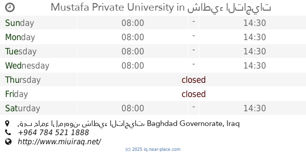
Mustafa Private University
قرب جامع المرهون, شاطيء التاجيات
University
Point of interest
Establishment
read more
2.253 km
Kadhimiyah Train Station
Baghdad
Train station
Transit station
Point of interest
Establishment
read more
📑
all categories
Accounting
Airport
Amusement park
Aquarium
Art gallery
Atm
Bakery
Bank
Bar
Beauty salon
Bicycle store
Book store
Bowling alley
Bus station
Cafe
Campground
Car dealer
Car rental
Car repair
Car wash
Casino
Cemetery
Church
City hall
Clothing store
Convenience store
Courthouse
Dentist
Department store
Doctor
Electrician
Electronics store
Embassy
Establishment
Finance
Fire station
Florist
Food
Funeral home
Furniture store
Gas station
General contractor
Grocery or supermarket
Gym
Hair care
Hardware store
Health
Hindu Temple
Home goods store
Hospital
Insurance agency
Jewelry store
Laundry
Lawyer
Library
Liquor store
Local government office
Locality
Locksmith
Lodging
Meal delivery
Meal takeaway
Mosque
Movie theater
Moving company
Museum
Neighborhood
Night club
Painter
Park
Parking
Pet store
Pharmacy
Physiotherapist
Place of worship
Plumber
Point of interest
Police
Political
Post office
Premise
Real estate agency
Restaurant
Roofing contractor
Route
Rv park, camping
School
Shoe store
Shopping mall
Spa
Stadium
Storage
Store
Sublocality
Supermarket
Synagogue
Taxi stand
Train station
Transit station
Travel agency
University
Veterinary care
Zoo
sublocality level 1
↑