Establishment nearby ملعب القوة الجوية
Iraq
Establishment nearby ملعب القوة الجوية
ملعب القوة الجوية
9F32+675، بغداد،،, Baghdad, 9 Nissan, IQ Iraq
contacts phone
:
+964
Latitude:
33.351649
, Longitude:
44.4511899
larger map & directions
read more
nearest Establishment
217 m
Selling sheep market (Juba)
8FX2+VCC, Umal Street, Baghdad
Pet store
Point of interest
Store
Establishment
read more
508 m
Al-Madina International Stadium
Bor Said Street, Baghdad
Stadium
Point of interest
Establishment
read more
732 m
Al-Shohada International
شارع المعارض, بغداد
Stadium
Point of interest
Establishment
read more
921 m
Helipad
8CWV+Q68, Baghdad
Airport
Point of interest
Establishment
read more
1.058 km
النواب
9F63+2W2, Baghdad
Local government office
Courthouse
Point of interest
Establishment
read more
1.291 km
ستوديو HS للانتاج الفني
9C6R+4Q4 Baghdad مدينة الصدر
Movie theater
Point of interest
Establishment
read more
1.444 km
Ward complex to American goods
9C3P+679, شارع, Baghdad
Shopping mall
Point of interest
Establishment
read more
1.481 km
الشيخ أبو حسن العلياوي
9C6R+XP2, Baghdad
Insurance agency
Point of interest
Establishment
read more
1.571 km
كوفي روزويلا
9F39+65X شارع القدس، بغداد،، بغداد،, Baghdad
Casino
Point of interest
Establishment
read more
1.787 km
مطعم الزهراء
9C8W+WVR, Baghdad
Restaurant
Food
Point of interest
Establishment
read more
1.824 km
محلات الحاج محمد عريبي
بغداد مدينة الصدر شارع القدس, Baghdad
Plumber
Electrician
Home goods store
Store
Point of interest
Establishment
read more
1.875 km
Al-Najat Secondary School For Girls
9F95+23X
School
Point of interest
Establishment
read more
1.979 km
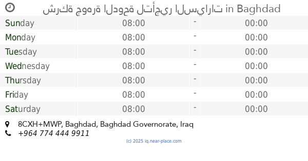
شركة جوهرة الدوحة لتأجير السيارات
8CXH+MWP, Baghdad
Car rental
Point of interest
Establishment
read more
2.08 km
حجي بارق
8CVJ+F9R, شارع فلسطين, بغداد
Museum
Point of interest
Establishment
read more
2.359 km
مطعم انجل Angel Restaurant
قطاع 8, بغداد
Meal takeaway
Restaurant
Point of interest
Food
Establishment
read more
📑
all categories
Accounting
Airport
Amusement park
Aquarium
Art gallery
Atm
Bakery
Bank
Bar
Beauty salon
Bicycle store
Book store
Bowling alley
Bus station
Cafe
Campground
Car dealer
Car rental
Car repair
Car wash
Casino
Cemetery
Church
City hall
Clothing store
Convenience store
Courthouse
Dentist
Department store
Doctor
Electrician
Electronics store
Embassy
Establishment
Finance
Fire station
Florist
Food
Funeral home
Furniture store
Gas station
General contractor
Grocery or supermarket
Gym
Hair care
Hardware store
Health
Hindu Temple
Home goods store
Hospital
Insurance agency
Jewelry store
Laundry
Lawyer
Library
Liquor store
Local government office
Locality
Locksmith
Lodging
Meal delivery
Meal takeaway
Mosque
Movie theater
Moving company
Museum
Neighborhood
Night club
Painter
Park
Parking
Pet store
Pharmacy
Physiotherapist
Place of worship
Plumber
Point of interest
Police
Political
Post office
Premise
Real estate agency
Restaurant
Roofing contractor
Route
Rv park, camping
School
Shoe store
Shopping mall
Spa
Stadium
Storage
Store
Sublocality
Supermarket
Synagogue
Taxi stand
Train station
Transit station
Travel agency
University
Veterinary care
Zoo
sublocality level 1
↑