Establishment nearby ملعب ابو حوراء
Iraq
Establishment nearby ملعب ابو حوراء
ملعب ابو حوراء
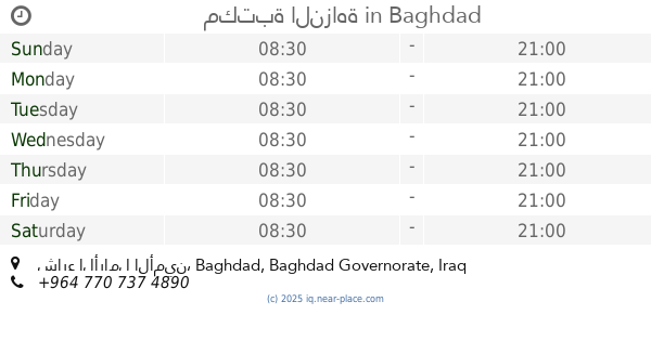
2000، امين، Baghdad, Baghdad Governorate, Iraq
contacts phone
:
+964
Latitude:
33.2925303
, Longitude:
44.5221476
larger map & directions
read more
nearest Establishment
1.199 km
مدرسة فلسطين للبنين
الثانية, 8G3F+823 بغداد الامين
School
Point of interest
Establishment
read more
1.345 km
Al-Amin Police Station
8G3F+R3W, مركز شرطة الامين, Baghdad
Police
Point of interest
Establishment
read more
1.483 km
بيت ابو قتيبة
8G37+MQM, Baghdad
Hindu Temple
Place of worship
Point of interest
Establishment
read more
1.543 km
المهداوي/ ادوات احتياطية للدراجات
8G4C+HGC, الامين الثانية/نهاية شارع نواب الضباط/قرب تقاطع الزهور🚩 بغداد الامين, Baghdad
Bicycle store
Store
Point of interest
Establishment
read more
1.866 km
VIP
٣٣٫٣٠٨٧٤٨٩، ٤٤٫٥١٧٠١٢٦, بغداد
Airport
Point of interest
Establishment
read more
1.928 km
Al-Israa and Al-Miraj Mosque
8G34+PP5, Baghdad
Mosque
Place of worship
Point of interest
Establishment
read more
1.929 km
مكتبة النزاهة
الثانية, شارع الأرامل الأمين, Baghdad
Shopping mall
Point of interest
Establishment
read more
2.473 km
Al-Amin Park
8G76+7WF, الامين الثانية, Baghdad
Park
Point of interest
Establishment
read more
2.551 km
سنتر النجوم للستلايت وشبكات البث الرقمي
8G75+2GX
Movie theater
Point of interest
Establishment
read more
2.737 km
محمد جعفر
8G8H+GG, Baghdad
Meal delivery
Point of interest
Food
Establishment
read more
2.791 km
اسواق كرار
8G74+JJ5, Baghdad
School
Point of interest
Establishment
read more
2.846 km
كادر النرجس للتاسيسات الصحية
Baghdad
Plumber
Point of interest
Establishment
read more
3.386 km
جاي كرار الركابي
8F4Q+2HP
Liquor store
Store
Point of interest
Establishment
read more
3.438 km
علي القريشي
8G92+6GP, Baghdad
Meal delivery
Point of interest
Food
Establishment
read more
4.223 km
محكمة كاتب العدل
8F6M+M5C, Baghdad
Local government office
Courthouse
Point of interest
Establishment
read more
📑
all categories
Accounting
Airport
Amusement park
Aquarium
Art gallery
Atm
Bakery
Bank
Bar
Beauty salon
Bicycle store
Book store
Bowling alley
Bus station
Cafe
Campground
Car dealer
Car rental
Car repair
Car wash
Casino
Cemetery
Church
City hall
Clothing store
Convenience store
Courthouse
Dentist
Department store
Doctor
Electrician
Electronics store
Embassy
Establishment
Finance
Fire station
Florist
Food
Funeral home
Furniture store
Gas station
General contractor
Grocery or supermarket
Gym
Hair care
Hardware store
Health
Hindu Temple
Home goods store
Hospital
Insurance agency
Jewelry store
Laundry
Lawyer
Library
Liquor store
Local government office
Locality
Locksmith
Lodging
Meal delivery
Meal takeaway
Mosque
Movie theater
Moving company
Museum
Neighborhood
Night club
Painter
Park
Parking
Pet store
Pharmacy
Physiotherapist
Place of worship
Plumber
Point of interest
Police
Political
Post office
Premise
Real estate agency
Restaurant
Roofing contractor
Route
Rv park, camping
School
Shoe store
Shopping mall
Spa
Stadium
Storage
Store
Sublocality
Supermarket
Synagogue
Taxi stand
Train station
Transit station
Travel agency
University
Veterinary care
Zoo
sublocality level 1
↑