Establishment nearby المملكه
Iraq
Establishment nearby المملكه
المملكه
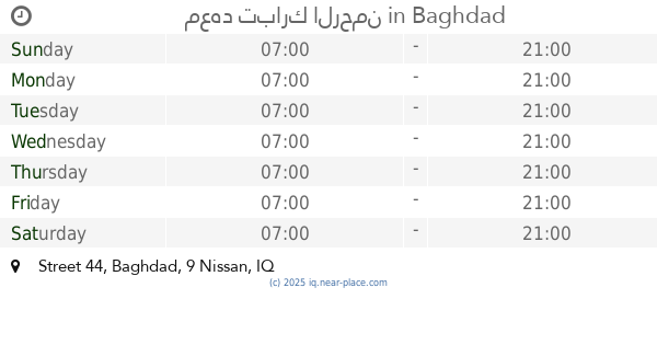
8GX3+J56، بغداد، بغداد محافظة، Iraq
contacts phone
:
+964
Latitude:
33.3490442
, Longitude:
44.5028853
larger map & directions
read more
nearest Establishment
24 m
Fire Arboretum
8GX3+M4V, Baghdad
Fire station
Point of interest
Establishment
read more
402 m
مركز Romel لخدمات الانترنت
8FXX+MCF, Baghdad
Shopping mall
Point of interest
Establishment
read more
566 m
Habib Bonded Office
9G24+XWX, Baghdad
Department store
Store
Point of interest
Establishment
read more
656 m
مكتب SRT لخدمات الانترنت
8FXW+F84, Unnamed Road،, Baghdad
Electronics store
Store
Point of interest
Establishment
read more
851 m
مطعم قائم آل محمد
8GX6+CR6
Restaurant
Food
Point of interest
Establishment
read more
864 m
Al-Ghadeer Restaurant
8GX6+GVF, Unnamed Road,, Baghdad
Restaurant
Food
Point of interest
Establishment
read more
866 m
كرار الشمري
9F2V+HJC, Baghdad
Campground
Lodging
Park
Point of interest
Establishment
read more
1.104 km
محكمة بغداد الجديدة
8FWR+PGM, البلديات، بغداد،, Baghdad
Courthouse
Local government office
Point of interest
Establishment
read more
1.644 km
ابو عبدالله احمد فاخر الحسيناوي
9F3P+79V, Baghdad
Rv park, camping
Lodging
Point of interest
Establishment
read more
1.978 km
Coffee Shop Ahmed Jarallah
9G77+JPM, Baghdad
Cafe
Food
Point of interest
Establishment
read more
2.044 km
اسواق النباء
9G87+54M, Baghdad
Shopping mall
Point of interest
Establishment
read more
2.115 km
فني كامرات نت ستلايت بث رقمي
شارع المدارس, Baghdad
Art gallery
Point of interest
Establishment
read more
2.151 km
البلديت
9F4J+JHP, Baghdad
Meal delivery
Food
Point of interest
Establishment
read more
2.321 km
Futsal stadium
8FJQ+R96, Unnamed Road, Baghdad
Stadium
Point of interest
Establishment
read more
2.721 km
معهد تبارك الرحمن
33.332280,481766, Street 44
School
Point of interest
Establishment
read more
📑
all categories
Accounting
Airport
Amusement park
Aquarium
Art gallery
Atm
Bakery
Bank
Bar
Beauty salon
Bicycle store
Book store
Bowling alley
Bus station
Cafe
Campground
Car dealer
Car rental
Car repair
Car wash
Casino
Cemetery
Church
City hall
Clothing store
Convenience store
Courthouse
Dentist
Department store
Doctor
Electrician
Electronics store
Embassy
Establishment
Finance
Fire station
Florist
Food
Funeral home
Furniture store
Gas station
General contractor
Grocery or supermarket
Gym
Hair care
Hardware store
Health
Hindu Temple
Home goods store
Hospital
Insurance agency
Jewelry store
Laundry
Lawyer
Library
Liquor store
Local government office
Locality
Locksmith
Lodging
Meal delivery
Meal takeaway
Mosque
Movie theater
Moving company
Museum
Neighborhood
Night club
Painter
Park
Parking
Pet store
Pharmacy
Physiotherapist
Place of worship
Plumber
Point of interest
Police
Political
Post office
Premise
Real estate agency
Restaurant
Roofing contractor
Route
Rv park, camping
School
Shoe store
Shopping mall
Spa
Stadium
Storage
Store
Sublocality
Supermarket
Synagogue
Taxi stand
Train station
Transit station
Travel agency
University
Veterinary care
Zoo
sublocality level 1
↑