Lodging nearby كرار الشمري
Iraq
Lodging nearby كرار الشمري
كرار الشمري
9F2V+HJC, Baghdad, Baghdad Governorate, Iraq
contacts phone
:
+964
Latitude:
33.3514375
, Longitude:
44.4940156
larger map & directions
read more
nearest Lodging
600 m
صالح الكعبي
8FWQ+WXR, Al Kanisa Street, Baghdad
Campground
Park
Lodging
Point of interest
Establishment
read more
778 m
ابو عبدالله احمد فاخر الحسيناوي
9F3P+79V, Baghdad
Rv park, camping
Lodging
Point of interest
Establishment
read more
3.051 km
بيت الشيخ علي ابو محمد المرعب اللامي
9GH2+942, بغداد
Campground
Park
Lodging
Point of interest
Establishment
read more
3.33 km
المشتل
8FCP+W85, Baghdad
Campground
Park
Lodging
Point of interest
Establishment
read more
4.635 km
بيت ابو فؤاد
9GFP+HC8, Baghdad
Campground
Park
Lodging
Point of interest
Establishment
read more
4.642 km
كراج الرشاد لمبيت التكتك والسيارات
9GQ8+G5F، بغداد،
Campground
Lodging
Park
Point of interest
Establishment
read more
4.677 km
كراج حيدر السوداني
9FVR+9QP, Baghdad
Campground
Lodging
Park
Point of interest
Establishment
read more
4.737 km
البيت عمر
8F6F+JV6, Baghdad
Campground
Park
Lodging
Point of interest
Establishment
read more
5.207 km
ساحة الحربكه
9FQ5+9QH, Baghdad
Rv park, camping
Lodging
Point of interest
Establishment
read more
6.981 km
كراج الاقصى
8C9J+82X, مقابل مستشفى الواسطي للكسور بالقرب من مستشفى العلوية للولادة نزلة جسر ملعب الشعب،, Baghdad
Rv park, camping
Lodging
Point of interest
Establishment
read more
9.241 km
ركن الغيبة.
7F9M+G8C, Baghdad
Campground
Lodging
Park
Point of interest
Establishment
read more
12.547 km
دار ابو فهد
8988+4C4, Baghdad
Lodging
Point of interest
Establishment
read more
12.548 km
كراج العمده
8988+3CW, Baghdad
Lodging
Point of interest
Establishment
read more
13.762 km
Hijry Hotel
986W+6FQ, Al Kadhim Street, Baghdad
Lodging
Point of interest
Establishment
read more
14.785 km
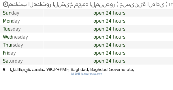
مكتب الدكتور الشيخ محمد المنصور ( حسينية الهادي )
98CP+PMF, الكاظمية، بغداد،, Baghdad
Campground
Lodging
Park
Point of interest
Establishment
read more
📑
all categories
Accounting
Airport
Amusement park
Aquarium
Art gallery
Atm
Bakery
Bank
Bar
Beauty salon
Bicycle store
Book store
Bowling alley
Bus station
Cafe
Campground
Car dealer
Car rental
Car repair
Car wash
Casino
Cemetery
Church
City hall
Clothing store
Convenience store
Courthouse
Dentist
Department store
Doctor
Electrician
Electronics store
Embassy
Establishment
Finance
Fire station
Florist
Food
Funeral home
Furniture store
Gas station
General contractor
Grocery or supermarket
Gym
Hair care
Hardware store
Health
Hindu Temple
Home goods store
Hospital
Insurance agency
Jewelry store
Laundry
Lawyer
Library
Liquor store
Local government office
Locality
Locksmith
Lodging
Meal delivery
Meal takeaway
Mosque
Movie theater
Moving company
Museum
Neighborhood
Night club
Painter
Park
Parking
Pet store
Pharmacy
Physiotherapist
Place of worship
Plumber
Point of interest
Police
Political
Post office
Premise
Real estate agency
Restaurant
Roofing contractor
Route
Rv park, camping
School
Shoe store
Shopping mall
Spa
Stadium
Storage
Store
Sublocality
Supermarket
Synagogue
Taxi stand
Train station
Transit station
Travel agency
University
Veterinary care
Zoo
sublocality level 1
↑