Cafe nearby كوفي عباس
Iraq
Cafe nearby كوفي عباس
كوفي عباس
شارع السوق, ناحية سومر, Diwaniya, IQ Iraq
contacts phone
:
+964
website:
amir.com
Latitude:
32.150473
, Longitude:
44.9988135
larger map & directions
read more
nearest Cafe
19.476 km
خطار كافيه
شارع السراي, Ad Diwaniyah
Cafe
Food
Point of interest
Establishment
read more
19.939 km
مقهى ابوغسان
XWMC+FF2, شارع الاطباء, Ad Diwaniyah
Cafe
Food
Point of interest
Establishment
read more
19.976 km
قاسم كنان
XWM9+MCM, شارع الاطباء, Ad Diwaniyah
Cafe
Store
Food
Point of interest
Establishment
read more
20.073 km
كافيه بن وحلوى
XWM8+P5P, Al Diwaniyah
Cafe
Food
Store
Point of interest
Establishment
read more
20.097 km
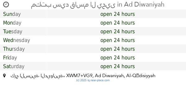
مكتب سيد قاسم ال يحيى
XWM7+VG9, كرج السنية، الديوانية،, Ad Diwaniyah
Cafe
Food
Point of interest
Establishment
read more
20.192 km
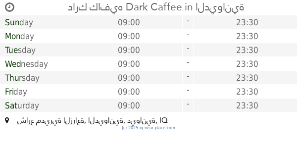
دارك كافيه Dark Caffee
XWM6+X7M, شارع مديرية الزراعة, الديوانية
Cafe
Store
Food
Point of interest
Establishment
read more
20.328 km
Al Diwaniya Cafe
XWM4+WWX, Al Diwaniyah
Cafe
Food
Point of interest
Establishment
read more
21.888 km
ديوانية مبارك ابوغانم ال بريك
مبارك ابوغانم ال بريك, الديوانية
Cafe
Store
Food
Point of interest
Establishment
read more
21.888 km
كوفي شوب استانبول
الديوانية،, شارع الكورنيش
Cafe
Food
Point of interest
Establishment
read more
21.888 km
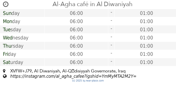
Al-Agha café
XVFW+J79, Al Diwaniyah
Cafe
Food
Store
Point of interest
Establishment
read more
21.888 km
كوفي الجزيرة العائلي
XVFW+J79, Al Diwaniyah
Cafe
Food
Store
Point of interest
Establishment
read more
21.888 km
تايم كافية
XVFW+J79, Al Diwaniyah
Cafe
Store
Point of interest
Food
Establishment
read more
21.888 km
كافيه علي السماك
شارع التحدي, الديوانية
Cafe
Food
Point of interest
Establishment
read more
21.888 km
كوفي أجواء المدينة
XVFW+J79, Al Diwaniyah
Cafe
Food
Point of interest
Establishment
read more
22.471 km
كوفي عبود لأمير
XV8X+X2V, طريق حلة - ديوانية, Ad Diwaniyah
Cafe
Food
Point of interest
Establishment
read more
📑
all categories
Accounting
Airport
Amusement park
Aquarium
Art gallery
Atm
Bakery
Bank
Bar
Beauty salon
Bicycle store
Book store
Bowling alley
Bus station
Cafe
Campground
Car dealer
Car rental
Car repair
Car wash
Casino
Cemetery
Church
City hall
Clothing store
Convenience store
Courthouse
Dentist
Department store
Doctor
Electrician
Electronics store
Embassy
Establishment
Finance
Fire station
Florist
Food
Funeral home
Furniture store
Gas station
General contractor
Grocery or supermarket
Gym
Hair care
Hardware store
Health
Hindu Temple
Home goods store
Hospital
Insurance agency
Jewelry store
Laundry
Lawyer
Library
Liquor store
Local government office
Locality
Locksmith
Lodging
Meal delivery
Meal takeaway
Mosque
Movie theater
Moving company
Museum
Neighborhood
Night club
Painter
Park
Parking
Pet store
Pharmacy
Physiotherapist
Place of worship
Plumber
Point of interest
Police
Political
Post office
Premise
Real estate agency
Restaurant
Roofing contractor
Route
Rv park, camping
School
Shoe store
Shopping mall
Spa
Stadium
Storage
Store
Sublocality
Supermarket
Synagogue
Taxi stand
Train station
Transit station
Travel agency
University
Veterinary care
Zoo
sublocality level 1
↑