Store nearby كافيه بن وحلوى
Iraq
Store nearby كافيه بن وحلوى
كافيه بن وحلوى
XWM8+P5P, Al Diwaniyah, Al-Qādisiyyah Governorate, Iraq
contacts phone
:
+964
Latitude:
31.9843252
, Longitude:
44.9154558
larger map & directions
read more
nearest Store
291 m
كوفي وهاب
XWM9+V9G, Al Diwaniyah
Cafe
Food
Point of interest
Store
Establishment
read more
300 m
قاسم كنان
XWM9+MCM, شارع الاطباء, Ad Diwaniyah
Cafe
Store
Food
Point of interest
Establishment
read more
343 m
سوبر ماركت البركه
XWJ8+G92, Al Diwaniyah
Supermarket
Grocery or supermarket
Store
Food
Point of interest
Establishment
read more
468 m
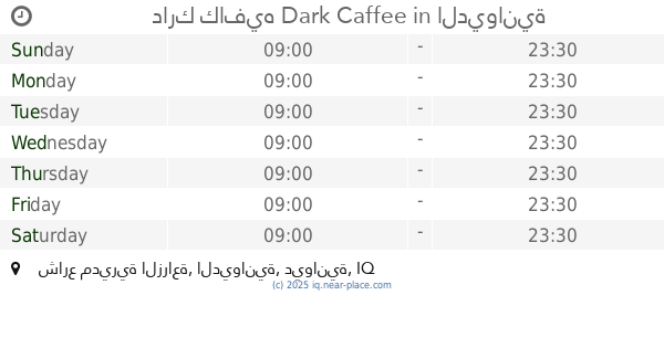
دارك كافيه Dark Caffee
XWM6+X7M, شارع مديرية الزراعة, الديوانية
Cafe
Store
Food
Point of interest
Establishment
read more
500 m
كوفي الدولية
XWMC+V7G, Al Diwaniyah
Cafe
Food
Point of interest
Store
Establishment
read more
527 m
كوفي حامد گنان
XWQ9+7H6, Al Diwaniyah
Cafe
Store
Food
Point of interest
Establishment
read more
609 m
ماڤن كافيه
XWJ6+49X, Al Diwaniyah
Cafe
Store
Point of interest
Food
Establishment
read more
743 m
مزاج كافيه
شارع السراي, Ad Diwaniyah
Cafe
Food
Point of interest
Store
Establishment
read more
777 m
كافية قرية الشام
XWM4+7W4, Al Diwaniyah
Cafe
Store
Food
Point of interest
Establishment
read more
787 m
مطعم و كافيه الطوفان
XWP4+JWM, شارع الجامعة, Ad Diwaniyah
Cafe
Store
Food
Point of interest
Establishment
read more
796 m
كوفي بيت الطين
XWP5+J2C, شارع البستان, Ad Diwaniyah
Cafe
Store
Food
Point of interest
Establishment
read more
813 m
كوفي الطاحونه
XWP5+X2C, Al Diwaniyah
Cafe
Store
Food
Point of interest
Establishment
read more
828 m
مقهى القمر
XWR8+JJF, Al Diwaniyah
Cafe
Food
Point of interest
Store
Establishment
read more
916 m
حكايتي كافيه
XWR6+VX3, Al Diwaniyah
Cafe
Food
Store
Point of interest
Establishment
read more
1.067 km
مركز كفيل 70
XWQ3+3WX, Al Diwaniyah
Supermarket
Grocery or supermarket
Store
Point of interest
Food
Establishment
read more
📑
all categories
Accounting
Airport
Amusement park
Aquarium
Art gallery
Atm
Bakery
Bank
Bar
Beauty salon
Bicycle store
Book store
Bowling alley
Bus station
Cafe
Campground
Car dealer
Car rental
Car repair
Car wash
Casino
Cemetery
Church
City hall
Clothing store
Convenience store
Courthouse
Dentist
Department store
Doctor
Electrician
Electronics store
Embassy
Establishment
Finance
Fire station
Florist
Food
Funeral home
Furniture store
Gas station
General contractor
Grocery or supermarket
Gym
Hair care
Hardware store
Health
Hindu Temple
Home goods store
Hospital
Insurance agency
Jewelry store
Laundry
Lawyer
Library
Liquor store
Local government office
Locality
Locksmith
Lodging
Meal delivery
Meal takeaway
Mosque
Movie theater
Moving company
Museum
Neighborhood
Night club
Painter
Park
Parking
Pet store
Pharmacy
Physiotherapist
Place of worship
Plumber
Point of interest
Police
Political
Post office
Premise
Real estate agency
Restaurant
Roofing contractor
Route
Rv park, camping
School
Shoe store
Shopping mall
Spa
Stadium
Storage
Store
Sublocality
Supermarket
Synagogue
Taxi stand
Train station
Transit station
Travel agency
University
Veterinary care
Zoo
sublocality level 1
↑