Restaurant nearby مندي واحه اليمن
Iraq
Restaurant nearby مندي واحه اليمن
مندي واحه اليمن
شارع التربية, 56001, Karbala', Karbala, IQ Iraq
contacts phone
:
+964
Latitude:
32.6060078
, Longitude:
44.0286306
larger map & directions
read more
nearest Restaurant
60 m
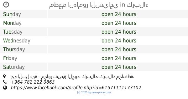
مطعم ام الربيعين
J24H+776, Karbala
Restaurant
Food
Point of interest
Establishment
read more
87 m
White chicken
J24H+839, Karbala
Restaurant
Food
Point of interest
Establishment
read more
133 m
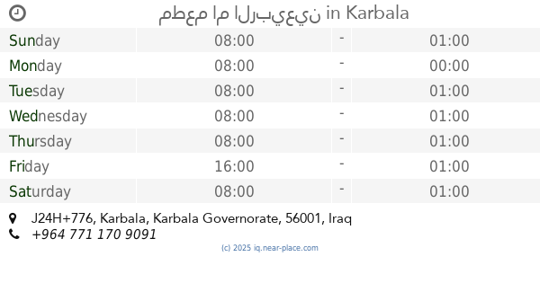
مطعم ومشويات حيدر مندي
شارع النبي محمد ص، كربلاء 56001،
Restaurant
Food
Point of interest
Establishment
read more
187 m
باقلاء و دهن ابو احمد
J23H+P8Q, Karbala
Restaurant
Food
Point of interest
Establishment
read more
377 m
مطعم الهامور السياحي
حي البلدية - مجاور فندق الجود, كربلاء
Restaurant
Food
Point of interest
Establishment
read more
557 m
مطعم بيت الطين
J23M+682, Al-Abbas Street, Karbala
Restaurant
Food
Point of interest
Establishment
read more
677 m
ستيك هاوس
شارع المجمعات، كربلاء 56001،
Restaurant
Food
Point of interest
Establishment
read more
700 m
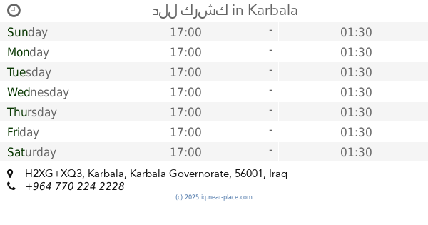
دلل كرشك
H2XG+XQ3, Karbala
Restaurant
Food
Point of interest
Establishment
read more
716 m
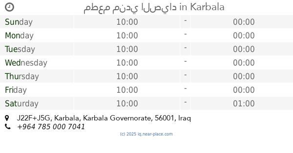
مطعم مندي الصياد
J22F+J5G, Karbala
Restaurant
Food
Point of interest
Establishment
read more
728 m
الشمري للتجهيزات الغذائية
H2XJ+XMJ, Al-Abbas Street, Karbala
Restaurant
Food
Point of interest
Establishment
read more
738 m
The Star Family
J22G+327, 56001 شارع السناتر, Karbala'
Restaurant
Food
Point of interest
Establishment
read more
752 m
مطعم إيميسا Emessa
H2XG+W2, Karbala
Restaurant
Food
Point of interest
Establishment
read more
755 m
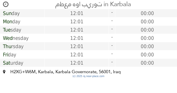
مطعم هوا بيروت
H2XG+W6M, Karbala
Restaurant
Food
Point of interest
Establishment
read more
939 m
مطعم جدو حيدر
56001 شارع حمزة الزغير، كربلاء 56001،
Restaurant
Food
Point of interest
Establishment
read more
1.158 km
شارع الباكلة
H2XP+5J8, Karbala
Restaurant
Food
Point of interest
Establishment
read more
📑
all categories
Accounting
Airport
Amusement park
Aquarium
Art gallery
Atm
Bakery
Bank
Bar
Beauty salon
Bicycle store
Book store
Bowling alley
Bus station
Cafe
Campground
Car dealer
Car rental
Car repair
Car wash
Casino
Cemetery
Church
City hall
Clothing store
Convenience store
Courthouse
Dentist
Department store
Doctor
Electrician
Electronics store
Embassy
Establishment
Finance
Fire station
Florist
Food
Funeral home
Furniture store
Gas station
General contractor
Grocery or supermarket
Gym
Hair care
Hardware store
Health
Hindu Temple
Home goods store
Hospital
Insurance agency
Jewelry store
Laundry
Lawyer
Library
Liquor store
Local government office
Locality
Locksmith
Lodging
Meal delivery
Meal takeaway
Mosque
Movie theater
Moving company
Museum
Neighborhood
Night club
Painter
Park
Parking
Pet store
Pharmacy
Physiotherapist
Place of worship
Plumber
Point of interest
Police
Political
Post office
Premise
Real estate agency
Restaurant
Roofing contractor
Route
Rv park, camping
School
Shoe store
Shopping mall
Spa
Stadium
Storage
Store
Sublocality
Supermarket
Synagogue
Taxi stand
Train station
Transit station
Travel agency
University
Veterinary care
Zoo
sublocality level 1
↑