Police nearby مديرية النجدة العامة آمرية نجدة المثنى
Iraq
Police nearby مديرية النجدة العامة آمرية نجدة المثنى
مديرية النجدة العامة آمرية نجدة المثنى
899R+2XJ, Baghdad, Baghdad Governorate, Iraq
contacts phone
:
+964
Latitude:
33.3175919
, Longitude:
44.3923892
larger map & directions
read more
nearest Police
2.447 km
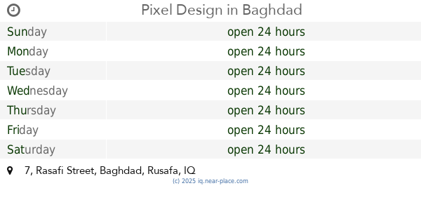
Pixel Design
8C9C+F34, 7 Rasafi Street, Baghdad
Police
Point of interest
Establishment
read more
2.835 km
مكتب مكافحة سرقة السيارات
8947+XQC
Police
Point of interest
Establishment
read more
2.837 km
مركز شرطة الحارثيه
8957+4MG, Baghdad
Police
Point of interest
Establishment
read more
2.906 km
الشرطة المجتمعية
89PC+XR6, Baghdad
Police
Point of interest
Establishment
read more
3.035 km
مركز شرطة باب الشيخ
8CR4+X9G, شيخ عمر، بغداد،, Baghdad
Police
Point of interest
Establishment
read more
3.044 km
قاطع نجدة الكرادة
8C6F+JPQ, Baghdad
Police
Point of interest
Establishment
read more
3.163 km
Mukhtar Rashad Sayed Talib al-Hassani
33°17'26.7"N 44°24'13., 1, Madain
Police
Local government office
Point of interest
Establishment
read more
3.348 km
Intelligence Center Harthiya
8955+G54, شارع المنصور, Baghdad
Police
Point of interest
Establishment
read more
3.656 km
مديرية مرور الكرخ / البيجية
89H4+C4M, Baghdad
Police
Point of interest
Establishment
read more
3.896 km
Agency Police Affears
8CPH+M2R, Baghdad
Police
Point of interest
Establishment
read more
4.012 km
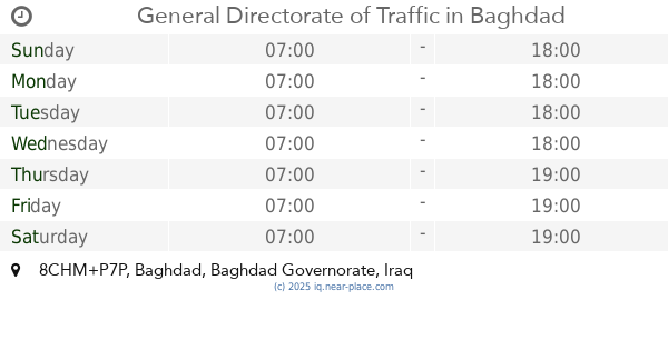
General Directorate of Traffic
8CHM+P7P, Baghdad
Police
Point of interest
Establishment
read more
4.342 km
مركز شرطة العلوية
8C5Q+X7H, 52nd Street, Baghdad
Police
Point of interest
Establishment
read more
4.359 km
مركز مكافحة الاجرام الكرادة
8C5Q+W89, 52nd Street, Baghdad
Police
Point of interest
Establishment
read more
4.386 km
Yarmouk Traffic Directorate
883X+69Q, شارع بيروت, Baghdad
Police
Point of interest
Establishment
read more
5.771 km
مركز شرطة مرور السلام
محلة 408 14 Ramadan Street, Baghdad
Police
Point of interest
Establishment
read more
📑
all categories
Accounting
Airport
Amusement park
Aquarium
Art gallery
Atm
Bakery
Bank
Bar
Beauty salon
Bicycle store
Book store
Bowling alley
Bus station
Cafe
Campground
Car dealer
Car rental
Car repair
Car wash
Casino
Cemetery
Church
City hall
Clothing store
Convenience store
Courthouse
Dentist
Department store
Doctor
Electrician
Electronics store
Embassy
Establishment
Finance
Fire station
Florist
Food
Funeral home
Furniture store
Gas station
General contractor
Grocery or supermarket
Gym
Hair care
Hardware store
Health
Hindu Temple
Home goods store
Hospital
Insurance agency
Jewelry store
Laundry
Lawyer
Library
Liquor store
Local government office
Locality
Locksmith
Lodging
Meal delivery
Meal takeaway
Mosque
Movie theater
Moving company
Museum
Neighborhood
Night club
Painter
Park
Parking
Pet store
Pharmacy
Physiotherapist
Place of worship
Plumber
Point of interest
Police
Political
Post office
Premise
Real estate agency
Restaurant
Roofing contractor
Route
Rv park, camping
School
Shoe store
Shopping mall
Spa
Stadium
Storage
Store
Sublocality
Supermarket
Synagogue
Taxi stand
Train station
Transit station
Travel agency
University
Veterinary care
Zoo
sublocality level 1
↑