Point of interest nearby عيادة الدكتور عمار سالم لطب الاسنان
Iraq
Point of interest nearby عيادة الدكتور عمار سالم لطب الاسنان
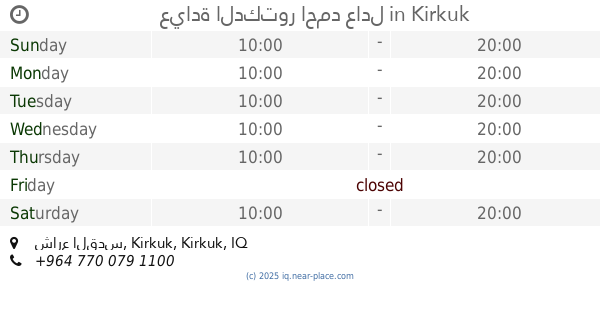
عيادة الدكتور عمار سالم لطب الاسنان
C9VP+HPF, Kirkuk, Kirkuk Governorate, Iraq
contacts phone
:
+964
Latitude:
35.4436475
, Longitude:
44.3869369
larger map & directions
read more
nearest Point of interest
728 m
سما بغداد للصيرفة
C9VH+7HM, Baghdad Road, Kirkuk
Bank
Finance
Point of interest
Establishment
read more
772 m
برج انترنيت
C9XV+7FF, Kirkuk
Post office
Finance
Point of interest
Establishment
read more
847 m
عيادة اسنانك
C9VH+23V, شارع القدس, Kirkuk
Dentist
Health
Point of interest
Establishment
read more
848 m
عيادة الدكتور اسامه محمد القيسي
C9QV+56P, Kirkuk
Dentist
Health
Point of interest
Establishment
read more
904 m
عيادة الدكتور محمد عبدالوهاب الصالحي
karbala ka
Dentist
Health
Point of interest
Establishment
read more
924 m
عيادة الدكتور احمد عادل
C9VG+RP3, شارع القدس, Kirkuk
Dentist
Point of interest
Health
Establishment
read more
932 m
مختار يوسف الهيبي
C9RW+8MJ, Kirkuk
Post office
Point of interest
Finance
Establishment
read more
946 m
منفذ وادي الزيتون 2
C9WG+2JQ، كركوك،
Atm
Finance
Point of interest
Establishment
read more
962 m
عيادة الدكتور احمد ناصح لطب وتجميل الاسنان
مجمع السيف الطبي, Kirkuk
Dentist
Health
Point of interest
Establishment
read more
997 m
شركة الوسيط للنقل العام والبريد السريع
C9VG+798, شارع القدس, Kirkuk
Post office
Finance
Point of interest
Establishment
read more
1.03 km
تاقیگەی لیفان
F92J+G4Q, Sulaimani - Kirkuk Road, Kirkuk
Dentist
Health
Point of interest
Establishment
read more
1.143 km
عيادة طب وتقويم الاسنان
C9QG+9CM, شارع القدس, Kirkuk
Dentist
Health
Point of interest
Establishment
read more
1.22 km
عيادة همام تيم
C9PG+GQJ, Baghdad Road, Kirkuk
Dentist
Health
Point of interest
Establishment
read more
1.671 km
مكتب تيث
F95P+38V, Kirkuk
Dentist
Health
Point of interest
Establishment
read more
2.141 km
أسواق حسين الحديدي
F96G+JV7، كركوك،
Supermarket
Grocery or supermarket
Food
Point of interest
Store
Establishment
read more
📑
all categories
Accounting
Airport
Amusement park
Aquarium
Art gallery
Atm
Bakery
Bank
Bar
Beauty salon
Bicycle store
Book store
Bowling alley
Bus station
Cafe
Campground
Car dealer
Car rental
Car repair
Car wash
Casino
Cemetery
Church
City hall
Clothing store
Convenience store
Courthouse
Dentist
Department store
Doctor
Electrician
Electronics store
Embassy
Establishment
Finance
Fire station
Florist
Food
Funeral home
Furniture store
Gas station
General contractor
Grocery or supermarket
Gym
Hair care
Hardware store
Health
Hindu Temple
Home goods store
Hospital
Insurance agency
Jewelry store
Laundry
Lawyer
Library
Liquor store
Local government office
Locality
Locksmith
Lodging
Meal delivery
Meal takeaway
Mosque
Movie theater
Moving company
Museum
Neighborhood
Night club
Painter
Park
Parking
Pet store
Pharmacy
Physiotherapist
Place of worship
Plumber
Point of interest
Police
Political
Post office
Premise
Real estate agency
Restaurant
Roofing contractor
Route
Rv park, camping
School
Shoe store
Shopping mall
Spa
Stadium
Storage
Store
Sublocality
Supermarket
Synagogue
Taxi stand
Train station
Transit station
Travel agency
University
Veterinary care
Zoo
sublocality level 1
↑