Point of interest nearby Sun Palace Hotel
Iraq
Point of interest nearby Sun Palace Hotel
Sun Palace Hotel
6XJQ+6X6, Erbil, Erbil Governorate, Iraq
contacts phone
:
+964
Latitude:
36.2305356
, Longitude:
43.9899042
larger map & directions
read more
nearest Point of interest
186 m
Fareeq
Hadyab St., 44003, Erbil
Lodging
Point of interest
Establishment
read more
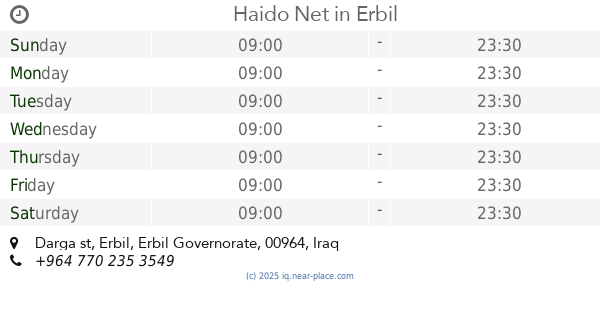
213 m
Haido Net
Darga st
Cafe
Food
Point of interest
Establishment
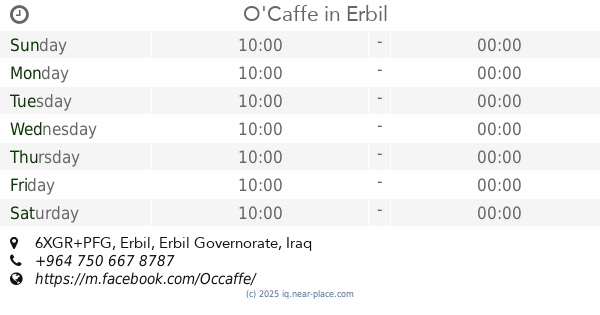
read more
429 m
O'Caffe
6XGR+PFG, Erbil
Cafe
Food
Point of interest
Establishment
read more
446 m
Santa Maria Medical Complex
6XGR+J8P, Erbil
Hospital
Health
Point of interest
Establishment
read more
535 m
Ankawa Post Office
6XJW+78H, Ankawa Boulevard, Erbil
Post office
Point of interest
Finance
Establishment
read more
641 m
Damasquino
شارع أفين, اربيل
Restaurant
Point of interest
Food
Store
Establishment
read more
674 m
lagash empire
mart shmoni /near hotel plamera, Erbil
Atm
Store
Finance
Point of interest
Establishment
read more
682 m
Economy Bank
6XFR+RMQ, Ainkawa, Erbil
Bank
Finance
Point of interest
Establishment
read more
741 m
Asenappar Hotel
6XPW+564, Erbil
Lodging
Point of interest
Establishment
read more
765 m
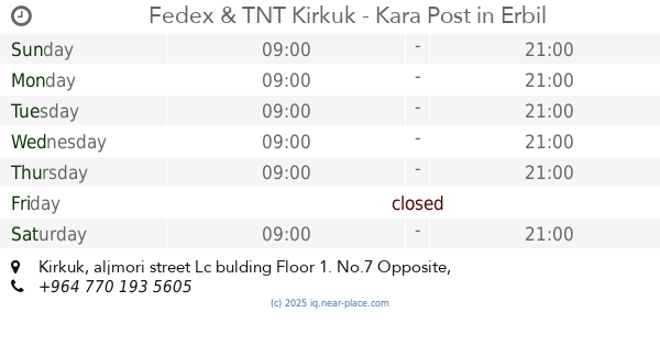
Fedex & TNT Kirkuk - Kara Post
Abdulla restaurant, Kirkuk, aljmori street Lc bulding Floor 1. No.7 Opposite
Post office
Finance
Point of interest
Establishment
read more
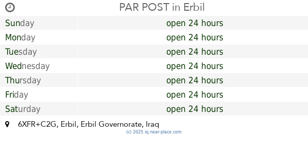
779 m
PAR POST
6XFR+C2G, Erbil
Post office
Finance
Point of interest
Establishment
read more
889 m
فندق بيوتي فان hotel beautyvan
44004 Shlama Street, Erbil
Lodging
Point of interest
Establishment
read more
895 m
Karwan Saray Hotel
6XPW+MGG, Shlama Street, Erbil
Lodging
Point of interest
Establishment
read more
1.025 km
HAYALI Suites Hotel
Shlama Street, Erbil
Lodging
Point of interest
Establishment
read more
1.044 km
Lamassu Hotel
100 Meter Road, Erbil
Lodging
Point of interest
Establishment
read more
📑
all categories
Accounting
Airport
Amusement park
Aquarium
Art gallery
Atm
Bakery
Bank
Bar
Beauty salon
Bicycle store
Book store
Bowling alley
Bus station
Cafe
Campground
Car dealer
Car rental
Car repair
Car wash
Casino
Cemetery
Church
City hall
Clothing store
Convenience store
Courthouse
Dentist
Department store
Doctor
Electrician
Electronics store
Embassy
Establishment
Finance
Fire station
Florist
Food
Funeral home
Furniture store
Gas station
General contractor
Grocery or supermarket
Gym
Hair care
Hardware store
Health
Hindu Temple
Home goods store
Hospital
Insurance agency
Jewelry store
Laundry
Lawyer
Library
Liquor store
Local government office
Locality
Locksmith
Lodging
Meal delivery
Meal takeaway
Mosque
Movie theater
Moving company
Museum
Neighborhood
Night club
Painter
Park
Parking
Pet store
Pharmacy
Physiotherapist
Place of worship
Plumber
Point of interest
Police
Political
Post office
Premise
Real estate agency
Restaurant
Roofing contractor
Route
Rv park, camping
School
Shoe store
Shopping mall
Spa
Stadium
Storage
Store
Sublocality
Supermarket
Synagogue
Taxi stand
Train station
Transit station
Travel agency
University
Veterinary care
Zoo
sublocality level 1
↑