Point of interest nearby مجمع وصفتي الطبي
Iraq
Point of interest nearby مجمع وصفتي الطبي
مجمع وصفتي الطبي
X8QH+P26 شارع حنون، صيدلية وصفتي ، عيادة الدكتور ماهر محمد الطاهر ، عيادة البقيع لطب الاسنان، النجف، النجف محافظة، Iraq
contacts phone
:
+964
Latitude:
31.98929
, Longitude:
44.3275189
larger map & directions
read more
nearest Point of interest
513 m
عيادة الكميل لطب الأسنان
X8RF+G3C, شارع المدينة, Najaf
Dentist
Health
Point of interest
Establishment
read more
561 m
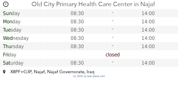
Old City Primary Health Care Center
X8PF+G3P, Najaf
Hospital
Health
Point of interest
Establishment
read more
644 m
عيادة يعسوب الدين
X8MJ+RM4, Najaf
Dentist
Point of interest
Health
Establishment
read more
711 m
عيادة الدكتور احمد وهاب السلامي لطب الاسنان
X8MJ+C9C, شارع الشرطة, Najaf
Dentist
Health
Point of interest
Establishment
read more
716 m
عيادة بغداد لطب الاسنان الدكتور احمد الطائي
X8MJ+JQQ, شارع الشرطة, Najaf
Dentist
Health
Point of interest
Establishment
read more
789 m
Hotel Sarah
X8WF+7G2, Najaf
Lodging
Point of interest
Establishment
read more
795 m
منفذ ميران لصرف البطاقه الذكيه
X8VC+648, شارع بنات الحسن (ع, Najaf
Bank
Finance
Point of interest
Establishment
read more
836 m
مركز الرعاية الصحية الاولية
Abdul Sahib Dkhil Primary Healthcare Center, Najaf
Hospital
Health
Point of interest
Establishment
read more
838 m
مستوصف البحر
El Jadida, Najaf
Hospital
Point of interest
Health
Establishment
read more
863 m
مقهى المدينة Al-Madinah Café
X8WC+4VH, Najaf
Cafe
Food
Point of interest
Store
Establishment
read more
970 m
Agricultural Cooperative Bank
عمارة الحياة, Najaf
Bank
Finance
Point of interest
Establishment
read more
1.035 km
Rafidain Bank, No. 7
X8WC+J7Q, Najaf
Bank
Finance
Point of interest
Establishment
read more
1.142 km
شركة طريق المسرة للصرافة
X8W9+HGP, Najaf
Bank
Finance
Point of interest
Establishment
read more
1.272 km
چاي احمد Ahmed tea
X8W9+P3R, Najaf
Cafe
Store
Food
Point of interest
Establishment
read more
1.295 km
كافيه دخان
X8X9+469, Najaf
Cafe
Food
Point of interest
Store
Establishment
read more
📑
all categories
Accounting
Airport
Amusement park
Aquarium
Art gallery
Atm
Bakery
Bank
Bar
Beauty salon
Bicycle store
Book store
Bowling alley
Bus station
Cafe
Campground
Car dealer
Car rental
Car repair
Car wash
Casino
Cemetery
Church
City hall
Clothing store
Convenience store
Courthouse
Dentist
Department store
Doctor
Electrician
Electronics store
Embassy
Establishment
Finance
Fire station
Florist
Food
Funeral home
Furniture store
Gas station
General contractor
Grocery or supermarket
Gym
Hair care
Hardware store
Health
Hindu Temple
Home goods store
Hospital
Insurance agency
Jewelry store
Laundry
Lawyer
Library
Liquor store
Local government office
Locality
Locksmith
Lodging
Meal delivery
Meal takeaway
Mosque
Movie theater
Moving company
Museum
Neighborhood
Night club
Painter
Park
Parking
Pet store
Pharmacy
Physiotherapist
Place of worship
Plumber
Point of interest
Police
Political
Post office
Premise
Real estate agency
Restaurant
Roofing contractor
Route
Rv park, camping
School
Shoe store
Shopping mall
Spa
Stadium
Storage
Store
Sublocality
Supermarket
Synagogue
Taxi stand
Train station
Transit station
Travel agency
University
Veterinary care
Zoo
sublocality level 1
↑