Point of interest nearby مجلس بلدي حي السلام
Iraq
Point of interest nearby مجلس بلدي حي السلام
مجلس بلدي حي السلام
787C+24W, Baghdad, Baghdad Governorate, Iraq
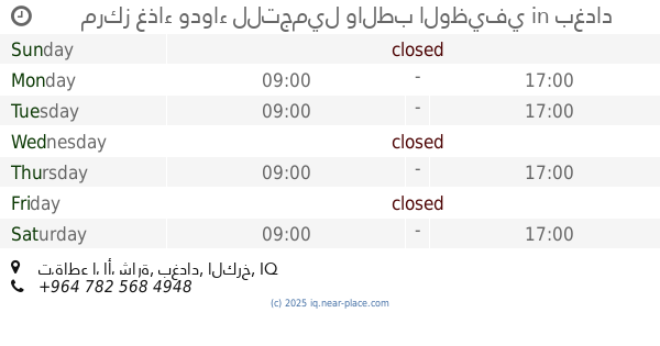
contacts phone
:
+964
Latitude:
33.262618
, Longitude:
44.3203292
larger map & directions
read more
nearest Point of interest
370 m
محاسب قانوني
301, ١٩, Baghdad
Accounting
Finance
Point of interest
Establishment
read more
707 m
مزرعة الشيخ فاضل العامري
784C+9VW, Baghdad
Campground
Park
Lodging
Point of interest
Establishment
read more
736 m
Haider Al-Rubaie Internet
7887+46X, مجمع الكرخ السكني،, Baghdad
Insurance agency
Point of interest
Establishment
read more
864 m
مركز دفاع مدني حي العامل
789G+M3W, شارع الشلامجة، بغداد،, Baghdad
Fire station
Point of interest
Establishment
read more
919 m
Al Mustafa Center for rehabilitation
784G+657, Baghdad
Physiotherapist
Health
Point of interest
Establishment
read more
948 m
Hudhaifah Aljcami Auto Repair
787J+Q43, Baghdad
Car repair
Point of interest
Establishment
read more
1.418 km
Al-Shams Central Automobile Exhibition
787P+963, Baghdad
Car dealer
Store
Point of interest
Establishment
read more
1.512 km
تاسيسات وتمديدات كهرباء/م مثنى نعيم
78FH+V64, Baghdad
Electrician
Point of interest
Establishment
read more
1.543 km
مجمع الجود الطبي
شارع الرافدين, بغداد
Spa
Health
Point of interest
Establishment
read more
1.591 km
مركز غذاء ودواء للتجميل والطب الوظيفي
مقابل دائرة المجاري, تقاطع الأشارة, بغداد
Physiotherapist
Health
Point of interest
Establishment
read more
1.835 km
Abu Ali al-Maliki markets
7833+9H8, Baghdad
Shopping mall
Point of interest
Establishment
read more
2.034 km
احمد سعد
7832+MC5, Baghdad
Campground
Lodging
Park
Point of interest
Establishment
read more
2.181 km
اسماك حجي علي عوفي
68WM+F7M, شارع قطر الندى, Baghdad
Meal takeaway
Restaurant
Food
Point of interest
Establishment
read more
2.289 km
كهربائيات السنك
شارع 30، بغداد،،
Hardware store
Point of interest
Store
Establishment
read more
2.528 km
مسترحنوش
78GR+X9G, Baghdad
Insurance agency
Point of interest
Establishment
read more
📑
all categories
Accounting
Airport
Amusement park
Aquarium
Art gallery
Atm
Bakery
Bank
Bar
Beauty salon
Bicycle store
Book store
Bowling alley
Bus station
Cafe
Campground
Car dealer
Car rental
Car repair
Car wash
Casino
Cemetery
Church
City hall
Clothing store
Convenience store
Courthouse
Dentist
Department store
Doctor
Electrician
Electronics store
Embassy
Establishment
Finance
Fire station
Florist
Food
Funeral home
Furniture store
Gas station
General contractor
Grocery or supermarket
Gym
Hair care
Hardware store
Health
Hindu Temple
Home goods store
Hospital
Insurance agency
Jewelry store
Laundry
Lawyer
Library
Liquor store
Local government office
Locality
Locksmith
Lodging
Meal delivery
Meal takeaway
Mosque
Movie theater
Moving company
Museum
Neighborhood
Night club
Painter
Park
Parking
Pet store
Pharmacy
Physiotherapist
Place of worship
Plumber
Point of interest
Police
Political
Post office
Premise
Real estate agency
Restaurant
Roofing contractor
Route
Rv park, camping
School
Shoe store
Shopping mall
Spa
Stadium
Storage
Store
Sublocality
Supermarket
Synagogue
Taxi stand
Train station
Transit station
Travel agency
University
Veterinary care
Zoo
sublocality level 1
↑