Point of interest nearby Met Library
Iraq
Point of interest nearby Met Library
Met Library
68GP+F9F, Baghdad, Baghdad Governorate, Iraq
contacts phone
:
+964 790 178 9026
website:
www.facebook.com
Latitude:
33.2261875
, Longitude:
44.3359375
larger map & directions
read more
nearest Point of interest
287 m
مادرا الطلي
Unnamed Road, Baghdad
Casino
Point of interest
Establishment
read more
289 m
Muhannad Jihad Pharmacy
68FM+RCC, شارع الربيعي, Baghdad
Pharmacy
Health
Store
Point of interest
Establishment
read more
546 m
زقاق 40
68CQ+CH، بغداد،،، بغداد،،
Campground
Lodging
Park
Point of interest
Establishment
read more
916 m
محمد الشمري
689M+6PM, Baghdad
Bicycle store
Point of interest
Store
Establishment
read more
1.292 km
Ahmed Satellite Office
68QQ+2H5, Baghdad
Electronics store
Store
Point of interest
Establishment
read more
1.503 km
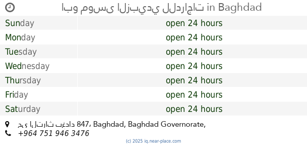
ابو موسى الزبيدي للدراجات
حي التراث بغداد 847
Bicycle store
Store
Point of interest
Establishment
read more
1.862 km
Center for Civil Defense Media
68RJ+W56, Baghdad
Fire station
Point of interest
Establishment
read more
1.864 km
الاطفاء
68RJ+W49, Baghdad
Fire station
Point of interest
Establishment
read more
1.885 km
قطعتنا 2023
العراق الدوانم
Campground
Lodging
Park
Point of interest
Establishment
read more
1.924 km
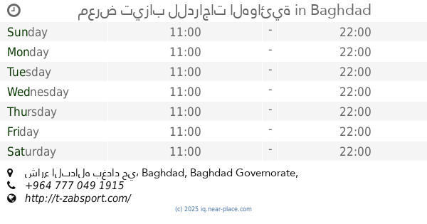
معرض تيزاب للدراجات الهوائية
Al Alam, شارع البداله بغداد حي
Bicycle store
Point of interest
Store
Establishment
read more
1.975 km
ملعب الرسالة الثانية
Baghdad
Stadium
Point of interest
Establishment
read more
2.009 km
دكان ستي
شارع 16, بغداد
Meal takeaway
Restaurant
Point of interest
Food
Establishment
read more
2.129 km
حلويات ومعجنات زينب
شارع الضغط, Baghdad
Bakery
Store
Food
Point of interest
Establishment
read more
2.135 km
العياده التمريضيه
69Q3+M52, Baghdad
Spa
Point of interest
Establishment
read more
2.773 km
مجمع الجود الطبي
شارع الرافدين, بغداد
Spa
Health
Point of interest
Establishment
read more
📑
all categories
Accounting
Airport
Amusement park
Aquarium
Art gallery
Atm
Bakery
Bank
Bar
Beauty salon
Bicycle store
Book store
Bowling alley
Bus station
Cafe
Campground
Car dealer
Car rental
Car repair
Car wash
Casino
Cemetery
Church
City hall
Clothing store
Convenience store
Courthouse
Dentist
Department store
Doctor
Electrician
Electronics store
Embassy
Establishment
Finance
Fire station
Florist
Food
Funeral home
Furniture store
Gas station
General contractor
Grocery or supermarket
Gym
Hair care
Hardware store
Health
Hindu Temple
Home goods store
Hospital
Insurance agency
Jewelry store
Laundry
Lawyer
Library
Liquor store
Local government office
Locality
Locksmith
Lodging
Meal delivery
Meal takeaway
Mosque
Movie theater
Moving company
Museum
Neighborhood
Night club
Painter
Park
Parking
Pet store
Pharmacy
Physiotherapist
Place of worship
Plumber
Point of interest
Police
Political
Post office
Premise
Real estate agency
Restaurant
Roofing contractor
Route
Rv park, camping
School
Shoe store
Shopping mall
Spa
Stadium
Storage
Store
Sublocality
Supermarket
Synagogue
Taxi stand
Train station
Transit station
Travel agency
University
Veterinary care
Zoo
sublocality level 1
↑