Point of interest nearby چایەخانەی دلشاد نازەنینی
Iraq
Point of interest nearby چایەخانەی دلشاد نازەنینی
چایەخانەی دلشاد نازەنینی
52Q7+H5H, Erbil, Erbil Governorate, Iraq
contacts phone
:
+964
Latitude:
36.1889375
, Longitude:
44.0129844
larger map & directions
read more
nearest Point of interest
236 m
مقهى
52R7+C29, Erbil
Store
Cafe
Point of interest
Establishment
Food
read more
245 m
كافيه قلعة ديرين
52Q6+37W, Erbil
Store
Cafe
Point of interest
Establishment
Food
read more
245 m
جيخانا مه جكو
52Q6+37W, Erbil
Cafe
Store
Point of interest
Establishment
Food
read more
300 m
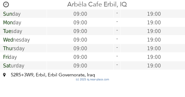
Arbêla Cafe
52R5+3W9, Erbil
Store
Cafe
Point of interest
Food
Establishment
read more
318 m
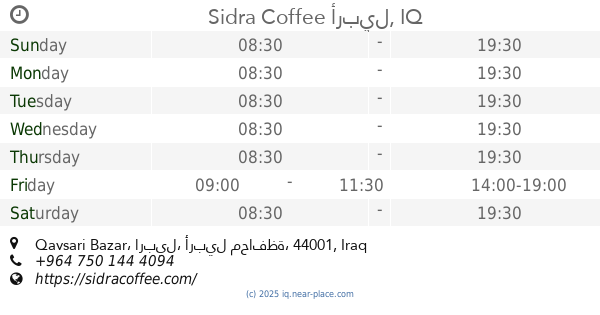
Sidra Coffee
Qaysari Bazar, Erbil
Establishment
Cafe
Food
Store
Point of interest
Restaurant
read more
431 m
Alesh Company
Kirkuk, Erbil
Supermarket
Grocery or supermarket
Point of interest
Food
Store
Establishment
read more
495 m
كباب ابو علي
52Q4+RXX, Erbil
Restaurant
Point of interest
Food
Establishment
read more
799 m
Rabar Market
52J6+PV9, Erbil
Supermarket
Grocery or supermarket
Point of interest
Food
Store
Establishment
read more
825 m
Dr. Ziwar's Dental Clinic
52V4+HF6، شیخ جولي, Erbil
Dentist
Health
Establishment
Point of interest
read more
826 m
Swe Dent
52R3+2HC, Sultan Muthafar, Erbil
Health
Establishment
Dentist
Point of interest
read more
826 m
AGA Building
52V4+HF6, Sherky Choly, شیخ جولي، Erbil
Establishment
Dentist
Lawyer
Point of interest
Health
read more
893 m
Hawler IT Center
Sultan Muthafar Market, Erbil
Bank
Finance
Point of interest
Establishment
read more
931 m
دکتۆر هێمن پزیشکی ددان
Erbil
Point of interest
Health
Dentist
Establishment
read more
1.041 km
Erbil D. Center
52V3+RFQ, Erbil
Hospital
Health
Point of interest
Establishment
read more
1.068 km
Soran Polyclinic
52W3+3H7, Pizhishkan, Erbil
Hospital
Health
Point of interest
Establishment
read more
📑
all categories
Accounting
Airport
Amusement park
Aquarium
Art gallery
Atm
Bakery
Bank
Bar
Beauty salon
Bicycle store
Book store
Bowling alley
Bus station
Cafe
Campground
Car dealer
Car rental
Car repair
Car wash
Casino
Cemetery
Church
City hall
Clothing store
Convenience store
Courthouse
Dentist
Department store
Doctor
Electrician
Electronics store
Embassy
Establishment
Finance
Fire station
Florist
Food
Funeral home
Furniture store
Gas station
General contractor
Grocery or supermarket
Gym
Hair care
Hardware store
Health
Hindu Temple
Home goods store
Hospital
Insurance agency
Jewelry store
Laundry
Lawyer
Library
Liquor store
Local government office
Locality
Locksmith
Lodging
Meal delivery
Meal takeaway
Mosque
Movie theater
Moving company
Museum
Neighborhood
Night club
Painter
Park
Parking
Pet store
Pharmacy
Physiotherapist
Place of worship
Plumber
Point of interest
Police
Political
Post office
Premise
Real estate agency
Restaurant
Roofing contractor
Route
Rv park, camping
School
Shoe store
Shopping mall
Spa
Stadium
Storage
Store
Sublocality
Supermarket
Synagogue
Taxi stand
Train station
Transit station
Travel agency
University
Veterinary care
Zoo
sublocality level 1
↑