Hospital nearby مجمع اللجان الطبية
Iraq
Hospital nearby مجمع اللجان الطبية
مجمع اللجان الطبية
7, Nasiriyah, Nassriya, IQ Iraq
contacts phone
:
+964
Latitude:
31.058351
, Longitude:
46.2475366
larger map & directions
read more
nearest Hospital
106 m
حسن العتابي
365W+JQR, Nasiriyah
Hospital
Health
Point of interest
Establishment
read more
161 m
الاحصاء الرئيسي
مستشفى الحسين التعليمي, An Nasiriyah
Hospital
Health
Point of interest
Establishment
read more
167 m
صالة عمليات الكسور
مستشفى الحسين التعليمي، مستشفى الحسين التعليمي, An Nasiriyah
Hospital
Health
Point of interest
Establishment
read more
237 m
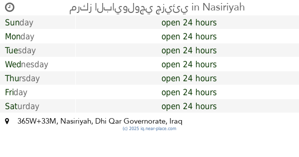
مركز البايولوجي جزيئي
365W+33M, Nasiriyah
Hospital
School
Health
Point of interest
Establishment
read more
237 m
Molecular Biology
365W+33M, Nasiriyah
Hospital
Health
School
Point of interest
Establishment
read more
257 m
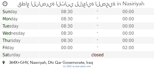
قطاع الناصرية الثاني للرعاية الصحية
364X+GHV, Nasiriyah
Hospital
Health
Point of interest
Establishment
read more
308 m
مركز الحسين (ع) لغسيل الكلى
365V+VV7, Nasiriyah
Hospital
Health
Point of interest
Establishment
read more
325 m
الكلية الصناعية
365V+XVW, Unnamed Road, Nasiriyah
Hospital
Health
Point of interest
Establishment
read more
837 m
مركز البشائر الصحي
البشائر, An Nasiriyah
Hospital
Health
Point of interest
Establishment
read more
887 m
المركز التخصصي لطب الاسنان / سومر
3754+FPP, Nasiriyah
Hospital
Health
Point of interest
Establishment
read more
1.208 km
موكب قادة الامم الحسيني
3724+CQ7, Nasiriyah
Hospital
Health
Point of interest
Establishment
read more
1.208 km
دكتوره سحاب اختصاص اطفال وحديث الولاده
3724+CQ7, Nasiriyah
Hospital
Health
Point of interest
Establishment
read more
1.208 km
احمد شنين
3724+CQ7, Nasiriyah
Hospital
Health
Point of interest
Establishment
read more
1.255 km
صيدلية اغادير
27X4+XJ6, Nasiriyah
Hospital
Health
Point of interest
Establishment
read more
1.294 km
مستشفى الربيع
26XQ+X84, Nasiriyah
Hospital
Health
Point of interest
Establishment
read more
📑
all categories
Accounting
Airport
Amusement park
Aquarium
Art gallery
Atm
Bakery
Bank
Bar
Beauty salon
Bicycle store
Book store
Bowling alley
Bus station
Cafe
Campground
Car dealer
Car rental
Car repair
Car wash
Casino
Cemetery
Church
City hall
Clothing store
Convenience store
Courthouse
Dentist
Department store
Doctor
Electrician
Electronics store
Embassy
Establishment
Finance
Fire station
Florist
Food
Funeral home
Furniture store
Gas station
General contractor
Grocery or supermarket
Gym
Hair care
Hardware store
Health
Hindu Temple
Home goods store
Hospital
Insurance agency
Jewelry store
Laundry
Lawyer
Library
Liquor store
Local government office
Locality
Locksmith
Lodging
Meal delivery
Meal takeaway
Mosque
Movie theater
Moving company
Museum
Neighborhood
Night club
Painter
Park
Parking
Pet store
Pharmacy
Physiotherapist
Place of worship
Plumber
Point of interest
Police
Political
Post office
Premise
Real estate agency
Restaurant
Roofing contractor
Route
Rv park, camping
School
Shoe store
Shopping mall
Spa
Stadium
Storage
Store
Sublocality
Supermarket
Synagogue
Taxi stand
Train station
Transit station
Travel agency
University
Veterinary care
Zoo
sublocality level 1
↑