Hospital nearby هيئة المعاقين
Iraq
Hospital nearby هيئة المعاقين
هيئة المعاقين
GQHR+R26, Basrah, Basra Governorate, Iraq
contacts phone
:
+964
Latitude:
30.5295488
, Longitude:
47.7900099
larger map & directions
read more
nearest Hospital
606 m
Liver and Digestive System Disease & Surgery Hospital
مركز المحافظة, البصرة
Hospital
Health
Point of interest
Establishment
read more
725 m
مركز معالجة الحروق الرئيسي
GQJM+W7V, Basrah
Hospital
Health
Point of interest
Establishment
read more
806 m
FDEMC
GQMM+74R, Basrah
Hospital
Health
Point of interest
Establishment
read more
811 m
Al-Fayhaa Teaching Hospital
GQMM+C5P, Basrah
Hospital
Health
Point of interest
Establishment
read more
811 m
ردهة الانعاش والعناية المركزة
GQMM+PFR
Hospital
Health
Point of interest
Establishment
read more
891 m
Dr. Ibrahim Clinic | عيادة الدكتور ابراهيم جبار العبادي
شارع المكاتب, Al Basrah
Doctor
Hospital
Point of interest
Health
Establishment
read more
898 m
اللجان الطبية الثانية
GQGX+QHJ
Hospital
Point of interest
Health
Establishment
read more
1.001 km
مركز صحي حكومي
GQFX+J8X, Basrah
Hospital
Health
Point of interest
Establishment
read more
1.009 km
المركز الصحي للرعاية الاولية
GQFX+M95, Basrah
Hospital
Point of interest
Health
Establishment
read more
1.361 km
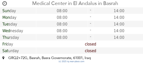
Medical Center in El Andalus
GRQ2+72G, Basrah
Hospital
Point of interest
Health
Establishment
read more
1.561 km
مجمع البهو الطبي
GRQ2+VG7, شارع البهو, Al Basrah
Hospital
Health
Point of interest
Establishment
read more
1.583 km
مركز الاساتذة للرعاية الصحية الاولية
GQPF+2W6, الاربع شوارع، بصرة،, Al Basrah
Hospital
Point of interest
Health
Establishment
read more
1.603 km
مركز الوطني
GQGF+9GV, Basrah
Hospital
Point of interest
Health
Establishment
read more
1.603 km
عياده الدكتور علي العيداني
GQGF+9GV, Basrah
Hospital
Point of interest
Health
Establishment
read more
2.069 km
عيادات الحمزة الطبية التعاونية
GQVG+VX6
Hospital
Health
Point of interest
Establishment
read more
📑
all categories
Accounting
Airport
Amusement park
Aquarium
Art gallery
Atm
Bakery
Bank
Bar
Beauty salon
Bicycle store
Book store
Bowling alley
Bus station
Cafe
Campground
Car dealer
Car rental
Car repair
Car wash
Casino
Cemetery
Church
City hall
Clothing store
Convenience store
Courthouse
Dentist
Department store
Doctor
Electrician
Electronics store
Embassy
Establishment
Finance
Fire station
Florist
Food
Funeral home
Furniture store
Gas station
General contractor
Grocery or supermarket
Gym
Hair care
Hardware store
Health
Hindu Temple
Home goods store
Hospital
Insurance agency
Jewelry store
Laundry
Lawyer
Library
Liquor store
Local government office
Locality
Locksmith
Lodging
Meal delivery
Meal takeaway
Mosque
Movie theater
Moving company
Museum
Neighborhood
Night club
Painter
Park
Parking
Pet store
Pharmacy
Physiotherapist
Place of worship
Plumber
Point of interest
Police
Political
Post office
Premise
Real estate agency
Restaurant
Roofing contractor
Route
Rv park, camping
School
Shoe store
Shopping mall
Spa
Stadium
Storage
Store
Sublocality
Supermarket
Synagogue
Taxi stand
Train station
Transit station
Travel agency
University
Veterinary care
Zoo
sublocality level 1
↑