Food nearby Pizza Pizza
Iraq
Food nearby Pizza Pizza
Pizza Pizza
29F2+QPH, Najaf, Najaf Governorate, Iraq
contacts phone
:
+964 782 209 9988
website:
pizzapizza.com
Latitude:
32.0244454
, Longitude:
44.3518657
larger map & directions
read more
nearest Food
368 m
Castle home shopping
29C3+VWV
Supermarket
Grocery or supermarket
Food
Point of interest
Store
Establishment
read more
1.906 km
JANAH SUPERMARKET
288M+5V4, Najaf
Supermarket
Grocery or supermarket
Store
Food
Point of interest
Establishment
read more
1.952 km
سوبر ماركت وفر
الحزام الاخضر, النجف
Supermarket
Grocery or supermarket
Store
Food
Point of interest
Establishment
read more
1.954 km
هايبر ماركت وفّر
الحزام الاخضر, النجف
Supermarket
Grocery or supermarket
Store
Food
Point of interest
Establishment
read more
1.988 km
فنش گيم
287P+G3R, Najaf
Cafe
Food
Point of interest
Store
Establishment
read more
1.989 km
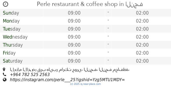
Perle restaurant & coffee shop
الحزام الاخضر قرب هايبر ماركت جوري, النجف
Restaurant
Cafe
Food
Store
Point of interest
Establishment
read more
1.998 km
مقهى ريحانه
28CJ+J9V, Najaf
Cafe
Store
Food
Point of interest
Establishment
read more
2.028 km
مطعم بيرلا
288J+VG, Najaf
Cafe
Store
Food
Point of interest
Establishment
read more
2.062 km
كافيةالتلال
288J+VG, Najaf
Cafe
Food
Point of interest
Store
Establishment
read more
2.096 km
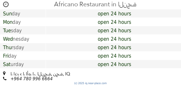
Africano Restaurant
289J+2F3, الغري الأول،, النجف
Cafe
Food
Store
Point of interest
Establishment
read more
2.131 km
مطعم وكافية كلكسي
288J+VG, Najaf
Store
Cafe
Point of interest
Food
Establishment
read more
2.38 km
اسواق علي الابراهيمي
286J+4X7, Kufa
Supermarket
Grocery or supermarket
Store
Food
Point of interest
Establishment
read more
2.527 km
اسواق علي الصلاخ
285M+F2J, Unnamed Road, Kufa
Supermarket
Grocery or supermarket
Store
Food
Point of interest
Establishment
read more
2.636 km
1000 c
284M+W2C
Supermarket
Grocery or supermarket
Food
Point of interest
Store
Establishment
read more
2.838 km
أمير ابو لفات
286G+7J6, Najaf
Restaurant
Food
Point of interest
Establishment
read more
📑
all categories
Accounting
Airport
Amusement park
Aquarium
Art gallery
Atm
Bakery
Bank
Bar
Beauty salon
Bicycle store
Book store
Bowling alley
Bus station
Cafe
Campground
Car dealer
Car rental
Car repair
Car wash
Casino
Cemetery
Church
City hall
Clothing store
Convenience store
Courthouse
Dentist
Department store
Doctor
Electrician
Electronics store
Embassy
Establishment
Finance
Fire station
Florist
Food
Funeral home
Furniture store
Gas station
General contractor
Grocery or supermarket
Gym
Hair care
Hardware store
Health
Hindu Temple
Home goods store
Hospital
Insurance agency
Jewelry store
Laundry
Lawyer
Library
Liquor store
Local government office
Locality
Locksmith
Lodging
Meal delivery
Meal takeaway
Mosque
Movie theater
Moving company
Museum
Neighborhood
Night club
Painter
Park
Parking
Pet store
Pharmacy
Physiotherapist
Place of worship
Plumber
Point of interest
Police
Political
Post office
Premise
Real estate agency
Restaurant
Roofing contractor
Route
Rv park, camping
School
Shoe store
Shopping mall
Spa
Stadium
Storage
Store
Sublocality
Supermarket
Synagogue
Taxi stand
Train station
Transit station
Travel agency
University
Veterinary care
Zoo
sublocality level 1
↑