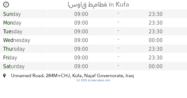
Food nearby نجف
Iraq
Food nearby نجف
نجف
X8XG+JXW, Najaf, Najaf Governorate, Iraq
contacts phone
:
+964
Latitude:
31.9990857
, Longitude:
44.3273989
larger map & directions
read more
nearest Food
291 m
باريستا
282J+425, Najaf
Cafe
Store
Food
Point of interest
Establishment
read more
492 m
اسواق نور الحسين
283J+34Q, 9, Najaf
Supermarket
Grocery or supermarket
Store
Food
Point of interest
Establishment
read more
518 m
مطعم سيد عباس باكلة بالدهن
283H+9PM, Najaf
Restaurant
Food
Point of interest
Establishment
read more
657 m
مقهى المدينة Al-Madinah Café
X8WC+4VH, Najaf
Cafe
Food
Point of interest
Store
Establishment
read more
669 m
محل ابو خلدون
283M+37R, Kufa
Supermarket
Grocery or supermarket
Food
Point of interest
Store
Establishment
read more
704 m
مطعم باقلاء بالدهن سيد عباس الاشبال
284H+4CM, Najaf
Restaurant
Food
Point of interest
Establishment
read more
774 m
كوفي ال جوهرة
X8WC+837, Najaf
Cafe
Food
Point of interest
Store
Establishment
read more
824 m
المرحوم صادق جعفر الجبوري
2829+VQ, Najaf
Restaurant
Food
Point of interest
Establishment
read more
826 m
اسواق ركن الحنانة
284H+GV2, Najaf
Supermarket
Grocery or supermarket
Store
Food
Point of interest
Establishment
read more
834 m
حلويات العنقود
284H+HGP, 9, Kufa
Restaurant
Food
Point of interest
Establishment
read more
857 m
Shops Abu Yasser
X8W9+JG8, Najaf
Supermarket
Grocery or supermarket
Store
Food
Point of interest
Establishment
read more
887 m
كافيه دخان
X8X9+469, Najaf
Cafe
Food
Point of interest
Store
Establishment
read more
957 m
چاي احمد Ahmed tea
X8W9+P3R, Najaf
Cafe
Store
Food
Point of interest
Establishment
read more
992 m
اسواق طماطة
284M+CHJ, Unnamed Road, Kufa
Supermarket
Grocery or supermarket
Store
Food
Point of interest
Establishment
read more
1.028 km
اسواق الصادق للتسوق
X8W8+MQV, Najaf
Supermarket
Grocery or supermarket
Store
Food
Point of interest
Establishment
read more
📑
all categories
Accounting
Airport
Amusement park
Aquarium
Art gallery
Atm
Bakery
Bank
Bar
Beauty salon
Bicycle store
Book store
Bowling alley
Bus station
Cafe
Campground
Car dealer
Car rental
Car repair
Car wash
Casino
Cemetery
Church
City hall
Clothing store
Convenience store
Courthouse
Dentist
Department store
Doctor
Electrician
Electronics store
Embassy
Establishment
Finance
Fire station
Florist
Food
Funeral home
Furniture store
Gas station
General contractor
Grocery or supermarket
Gym
Hair care
Hardware store
Health
Hindu Temple
Home goods store
Hospital
Insurance agency
Jewelry store
Laundry
Lawyer
Library
Liquor store
Local government office
Locality
Locksmith
Lodging
Meal delivery
Meal takeaway
Mosque
Movie theater
Moving company
Museum
Neighborhood
Night club
Painter
Park
Parking
Pet store
Pharmacy
Physiotherapist
Place of worship
Plumber
Point of interest
Police
Political
Post office
Premise
Real estate agency
Restaurant
Roofing contractor
Route
Rv park, camping
School
Shoe store
Shopping mall
Spa
Stadium
Storage
Store
Sublocality
Supermarket
Synagogue
Taxi stand
Train station
Transit station
Travel agency
University
Veterinary care
Zoo
sublocality level 1
↑