Finance nearby شركة المياس
Iraq
Finance nearby شركة المياس
شركة المياس
العدل, Ash Shatrah, Al-Shatra, IQ Iraq
contacts phone
:
+964
Latitude:
31.411192
, Longitude:
46.1675029
larger map & directions
read more
nearest Finance
232 m
Rafidain Bank
حي الزهراء, شارع الكورنيش, Ash Shatrah
Bank
Finance
Point of interest
Establishment
read more
12.683 km
كاظم ال شفيك
866H+2PM، غراف،
Post office
Point of interest
Finance
Establishment
read more
13.846 km
المختار علي جبار الكرخي
76XJ+RR3, Gharraf
Post office
Finance
Point of interest
Establishment
read more
14.417 km
زكريا سعود السعداوي
76XV+C32, Gharraf
Post office
Finance
Point of interest
Establishment
read more
14.417 km
المختار علي جبار الكرخي
76XV+C32, Gharraf
Post office
Finance
Point of interest
Establishment
read more
14.711 km
Al Garraf Post Office
76WV+FMC, Gharraf
Post office
Finance
Point of interest
Establishment
read more
38.834 km
GWES Operations Center 02
4936+MXW, Albu Jum'ah
Post office
Finance
Point of interest
Establishment
read more
40.359 km
مكتب الوطني 2. احمد جبار
377P+3HM, الناصرية
Post office
Point of interest
Finance
Establishment
read more
40.717 km
Gulf Commercial Bank
362R+6VP, شارع مجلس المحافظة, An Nasiriyah
Bank
Finance
Point of interest
Establishment
read more
40.821 km
مكتب الزين للبطاقة الذكية كي كارد
3724+VW9, Nile Street, Nasiriyah
Atm
Finance
Point of interest
Establishment
read more
40.934 km
اشرف سامي
3724+CQ7, Nasiriyah
Post office
Point of interest
Finance
Establishment
read more
41.489 km
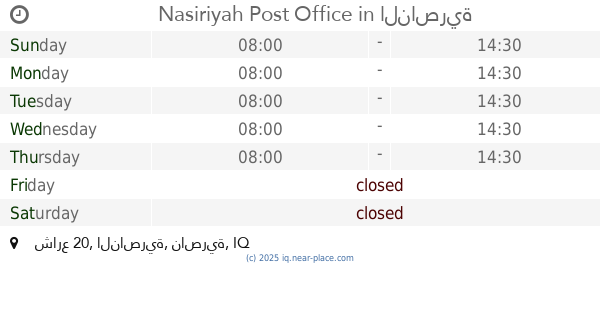
Nasiriyah Post Office
26VX+VWQ, شارع 20, الناصرية
Post office
Finance
Point of interest
Establishment
read more
41.656 km
Mesopotamia Exchange Company
27V4+QP3, Nasiriyah
Bank
Finance
Point of interest
Establishment
read more
42.008 km
ATM
26PH+Q42, Unnamed Road, Nasiriyah
Atm
Finance
Point of interest
Establishment
read more
42.149 km
قسم النظم المعلوماتية
26M7+J7R, Nasiriyah
Post office
Finance
Point of interest
Establishment
read more
📑
all categories
Accounting
Airport
Amusement park
Aquarium
Art gallery
Atm
Bakery
Bank
Bar
Beauty salon
Bicycle store
Book store
Bowling alley
Bus station
Cafe
Campground
Car dealer
Car rental
Car repair
Car wash
Casino
Cemetery
Church
City hall
Clothing store
Convenience store
Courthouse
Dentist
Department store
Doctor
Electrician
Electronics store
Embassy
Establishment
Finance
Fire station
Florist
Food
Funeral home
Furniture store
Gas station
General contractor
Grocery or supermarket
Gym
Hair care
Hardware store
Health
Hindu Temple
Home goods store
Hospital
Insurance agency
Jewelry store
Laundry
Lawyer
Library
Liquor store
Local government office
Locality
Locksmith
Lodging
Meal delivery
Meal takeaway
Mosque
Movie theater
Moving company
Museum
Neighborhood
Night club
Painter
Park
Parking
Pet store
Pharmacy
Physiotherapist
Place of worship
Plumber
Point of interest
Police
Political
Post office
Premise
Real estate agency
Restaurant
Roofing contractor
Route
Rv park, camping
School
Shoe store
Shopping mall
Spa
Stadium
Storage
Store
Sublocality
Supermarket
Synagogue
Taxi stand
Train station
Transit station
Travel agency
University
Veterinary care
Zoo
sublocality level 1
↑