Establishment nearby وانت شعليك
Iraq
Establishment nearby وانت شعليك
وانت شعليك
Unnamed Road، Hor Rajab, Babylon Governorate, Iraq
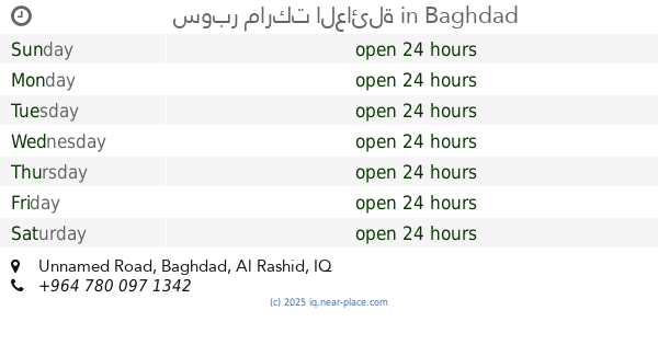
contacts phone
:
+964 780 431 7369
Latitude:
33.194311
, Longitude:
44.4133824
larger map & directions
read more
nearest Establishment
1.895 km
Al-Azzawi Group
6C65+F5, Baghdad
Campground
Park
Lodging
Point of interest
Establishment
read more
1.914 km
مزرعه الطائي
6C2J+FVW, جسر سريع الدورة, Baghdad
Campground
Lodging
Park
Point of interest
Establishment
read more
2.71 km
Hamid food store
696R+8Q2, Unnamed Rd, بغداد
Shopping mall
Point of interest
Establishment
read more
2.833 km
محل علاء بايسكلات
698X+MHJ, Baghdad
Bicycle store
Point of interest
Store
Establishment
read more
2.883 km
سوبر ماركت العائلة
696R+WC7, Unnamed Road, Baghdad
Shopping mall
Point of interest
Establishment
read more
3.132 km
متوسطة الصابر
696P+258, Baghdad
School
Point of interest
Establishment
read more
3.533 km
Abu-Al'amba Restaurant
698P+856, Baghdad
Restaurant
Food
Point of interest
Establishment
read more
3.719 km
ابو نايا
زقاق 27 محلة 854, Baghdad
Rv park, camping
Lodging
Point of interest
Establishment
read more
3.754 km
بانوراماديكور
شارع التجاري بغداد ابودشير
Painter
Point of interest
Establishment
read more
4.311 km
My room
59R8+VR5, كوريش حي السلام، بغداد،, Al-Masafer
Campground
Lodging
Park
Point of interest
Establishment
read more
4.355 km
Tawhid Mosque
6CJ2+VF5, Baghdad
Mosque
Place of worship
Point of interest
Establishment
read more
5.195 km
Sultan markets
6CPP+R8Q, Baghdad
Shopping mall
Point of interest
Establishment
read more
5.209 km
Samun Zahra furnaces
69JJ+W7W, Baghdad
Bakery
Food
Point of interest
Store
Establishment
read more
5.429 km
Sports fields-ملاعب رياضية
69GC+R28, Unnamed Road،, Baghdad
Stadium
Point of interest
Establishment
read more
5.486 km
زهره سبا
69PJ+GRM, Baghdad
Spa
Point of interest
Establishment
read more
📑
all categories
Accounting
Airport
Amusement park
Aquarium
Art gallery
Atm
Bakery
Bank
Bar
Beauty salon
Bicycle store
Book store
Bowling alley
Bus station
Cafe
Campground
Car dealer
Car rental
Car repair
Car wash
Casino
Cemetery
Church
City hall
Clothing store
Convenience store
Courthouse
Dentist
Department store
Doctor
Electrician
Electronics store
Embassy
Establishment
Finance
Fire station
Florist
Food
Funeral home
Furniture store
Gas station
General contractor
Grocery or supermarket
Gym
Hair care
Hardware store
Health
Hindu Temple
Home goods store
Hospital
Insurance agency
Jewelry store
Laundry
Lawyer
Library
Liquor store
Local government office
Locality
Locksmith
Lodging
Meal delivery
Meal takeaway
Mosque
Movie theater
Moving company
Museum
Neighborhood
Night club
Painter
Park
Parking
Pet store
Pharmacy
Physiotherapist
Place of worship
Plumber
Point of interest
Police
Political
Post office
Premise
Real estate agency
Restaurant
Roofing contractor
Route
Rv park, camping
School
Shoe store
Shopping mall
Spa
Stadium
Storage
Store
Sublocality
Supermarket
Synagogue
Taxi stand
Train station
Transit station
Travel agency
University
Veterinary care
Zoo
sublocality level 1
↑