Establishment nearby power center gym
Iraq
Establishment nearby power center gym
power center gym
8CXF+RC5, Baghdad, Baghdad Governorate, Iraq
contacts phone
:
+964 771 096 7441
website:
m.facebook.com
Latitude:
33.3495043
, Longitude:
44.4236033
larger map & directions
read more
nearest Establishment
71 m
مديرية الدفاع المدني / الرصافة
8CXF+PPG, Unnamed Road, Baghdad
Fire station
Point of interest
Establishment
read more
470 m
شجرة ابو الكيل وام الكيل
8CXH+PFF, Baghdad
Museum
Point of interest
Establishment
read more
483 m
BOB ATM
9C3F+GPF
Atm
Finance
Point of interest
Establishment
read more
566 m
مشتل ايهم البغدادي
8CXH+GV6, Unnamed Road, Baghdad
Pet store
Point of interest
Store
Establishment
read more
587 m
شركة موسى
8CW8+XV9, Baghdad
Moving company
Storage
Point of interest
Establishment
read more
601 m
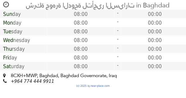
شركة جوهرة الدوحة لتأجير السيارات
8CXH+MWP, Baghdad
Car rental
Point of interest
Establishment
read more
684 m
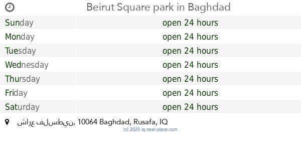
Beirut Square park
Industrial Bank of Iraq, شارع فلسطين, Baghdad
Amusement park
Point of interest
Establishment
read more
809 m
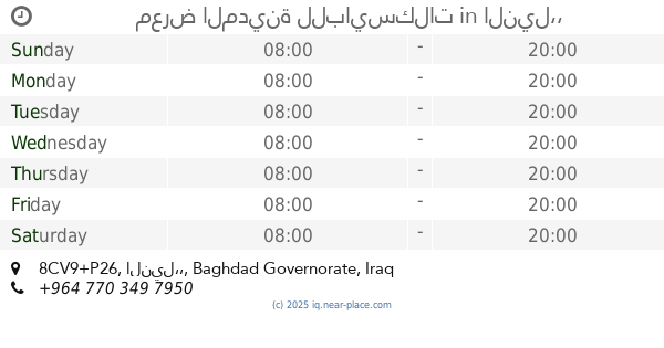
معرض المدينة للبايسكلات
8CV9+P26, النيل،،
Bicycle store
Point of interest
Store
Establishment
read more
835 m
مؤيد طيارة للدراجات الكهربائية
8CX7+WRX, Baghdad
Bicycle store
Point of interest
Store
Establishment
read more
840 m
يم يم كيك لعمل الكيك والمعجنات
9C4C+M79
Bakery
Food
Store
Point of interest
Establishment
read more
859 m
معرض مصطفى لتجارة الدراجات النارية
8CW8+953, شارع فلسطين, بغداد
Bicycle store
Point of interest
Store
Establishment
read more
874 m
شركة الملك
8CRF+JC, Baghdad
Car rental
Point of interest
Establishment
read more
931 m
حجي بارق
8CVJ+F9R, شارع فلسطين, بغداد
Museum
Point of interest
Establishment
read more
958 m
علي مندي
9C48+7HF, شارع فلسطين, بغداد
Car rental
Point of interest
Establishment
read more
1.049 km
المجلس البلدي - شارع فلسطين
9C5H+768, Palestine Street, Baghdad
City hall
Local government office
Point of interest
Establishment
read more
📑
all categories
Accounting
Airport
Amusement park
Aquarium
Art gallery
Atm
Bakery
Bank
Bar
Beauty salon
Bicycle store
Book store
Bowling alley
Bus station
Cafe
Campground
Car dealer
Car rental
Car repair
Car wash
Casino
Cemetery
Church
City hall
Clothing store
Convenience store
Courthouse
Dentist
Department store
Doctor
Electrician
Electronics store
Embassy
Establishment
Finance
Fire station
Florist
Food
Funeral home
Furniture store
Gas station
General contractor
Grocery or supermarket
Gym
Hair care
Hardware store
Health
Hindu Temple
Home goods store
Hospital
Insurance agency
Jewelry store
Laundry
Lawyer
Library
Liquor store
Local government office
Locality
Locksmith
Lodging
Meal delivery
Meal takeaway
Mosque
Movie theater
Moving company
Museum
Neighborhood
Night club
Painter
Park
Parking
Pet store
Pharmacy
Physiotherapist
Place of worship
Plumber
Point of interest
Police
Political
Post office
Premise
Real estate agency
Restaurant
Roofing contractor
Route
Rv park, camping
School
Shoe store
Shopping mall
Spa
Stadium
Storage
Store
Sublocality
Supermarket
Synagogue
Taxi stand
Train station
Transit station
Travel agency
University
Veterinary care
Zoo
sublocality level 1
↑