Establishment nearby نادي النفط الرياضي
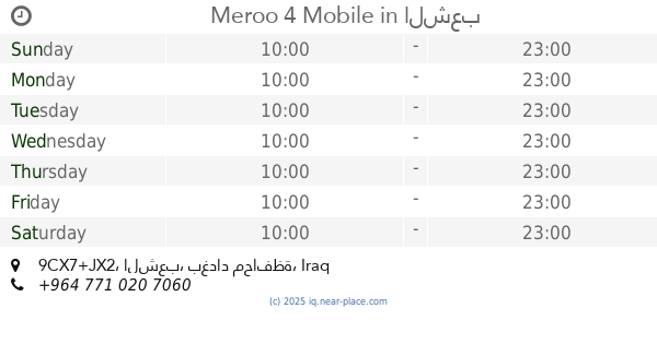
Iraq
Establishment nearby نادي النفط الرياضي
نادي النفط الرياضي
شارع نادي النفط, Baghdad, Adhamiyah, IQ Iraq
contacts phone
:
+964
website:
www.facebook.com
Latitude:
33.4026988
, Longitude:
44.4072798
larger map & directions
read more
nearest Establishment
191 m
ملعب سيد علالي
CC34+G36, Baghdad
Stadium
Point of interest
Establishment
read more
505 m
عـمر جمـال
CC43+98G, Baghdad
Rv park, camping
Lodging
Point of interest
Establishment
read more
799 m
لحم بعجين كهرمانة
9CX2+4C6, 23, Baghdad
Meal takeaway
Restaurant
Food
Point of interest
Establishment
read more
817 m
Meroo 4 Mobile
9CX7+JX2, الشعب
Electronics store
Store
Point of interest
Establishment
read more
912 m
حديقة الغدير
CC38+9RP, Baghdad
Park
Point of interest
Establishment
read more
930 m
القرش العاب واسرة الأطفال
9CX8+XMQ, Baghdad
Supermarket
Grocery or supermarket
Point of interest
Store
Food
Establishment
read more
961 m
Sweet Cakes
CC28+6WF
Bakery
Store
Food
Point of interest
Establishment
read more
984 m
Aber Al-Alam for Smart Phones
CC29+522, Baghdad
Electronics store
Store
Point of interest
Establishment
read more
1.05 km
اللمسة الناعمة
9CW2+26R, Baghdad
Doctor
Health
Point of interest
Establishment
read more
1.073 km
Italian Barber Salon
23, Baghdad
Hair care
Health
Point of interest
Establishment
read more
1.092 km
منتجات المحيط
23، مدينة الشعب، بغداد العراق
Pet store
Store
Point of interest
Establishment
read more
1.13 km
Al-Badriya Mosque
C95X+P55, Baghdad
Mosque
Place of worship
Point of interest
Establishment
read more
1.257 km
شاورما ابو العبد / البنوك
99VW+XX7, Baghdad
Meal takeaway
Restaurant
Food
Point of interest
Establishment
read more
1.292 km
Almadar For Computers
C96W+7R5
Electronics store
Store
Point of interest
Establishment
read more
2.028 km
توترز
C98V+P85, Baghdad
Meal delivery
Food
Point of interest
Establishment
read more
📑
all categories
Accounting
Airport
Amusement park
Aquarium
Art gallery
Atm
Bakery
Bank
Bar
Beauty salon
Bicycle store
Book store
Bowling alley
Bus station
Cafe
Campground
Car dealer
Car rental
Car repair
Car wash
Casino
Cemetery
Church
City hall
Clothing store
Convenience store
Courthouse
Dentist
Department store
Doctor
Electrician
Electronics store
Embassy
Establishment
Finance
Fire station
Florist
Food
Funeral home
Furniture store
Gas station
General contractor
Grocery or supermarket
Gym
Hair care
Hardware store
Health
Hindu Temple
Home goods store
Hospital
Insurance agency
Jewelry store
Laundry
Lawyer
Library
Liquor store
Local government office
Locality
Locksmith
Lodging
Meal delivery
Meal takeaway
Mosque
Movie theater
Moving company
Museum
Neighborhood
Night club
Painter
Park
Parking
Pet store
Pharmacy
Physiotherapist
Place of worship
Plumber
Point of interest
Police
Political
Post office
Premise
Real estate agency
Restaurant
Roofing contractor
Route
Rv park, camping
School
Shoe store
Shopping mall
Spa
Stadium
Storage
Store
Sublocality
Supermarket
Synagogue
Taxi stand
Train station
Transit station
Travel agency
University
Veterinary care
Zoo
sublocality level 1
↑