Establishment nearby مزرعة الورود
Iraq
Establishment nearby مزرعة الورود
مزرعة الورود
6FHC+34M, Baghdad, Baghdad Governorate, Iraq
contacts phone
:
+964
Latitude:
33.2277156
, Longitude:
44.4703036
larger map & directions
read more
nearest Establishment
1.285 km
مزرعه المريم
6F8G+R6, Baghdad
Campground
Park
Lodging
Point of interest
Establishment
read more
1.443 km
مركز دفاع مدني الزعفرانية
6FQH+H73, Baghdad
Fire station
Point of interest
Establishment
read more
1.532 km
الساده البوعيثه
6F8H+67, Baghdad
Campground
Lodging
Park
Point of interest
Establishment
read more
2.224 km
Stadium altadamun
6FVM+HPF, Baghdad
Stadium
Point of interest
Establishment
read more
2.76 km
مدينة البراغشة
6F5Q+FCW, Baghdad
City hall
Local government office
Point of interest
Establishment
read more
2.807 km
ملعب جاسم شبر
6FXC+JM9, Baghdad
Stadium
Point of interest
Establishment
read more
2.989 km
جامع التوبة
iraq , baghdad , aldora
Mosque
Place of worship
Point of interest
Establishment
read more
3.136 km
مجمع شواطئ دجلة
6CWW+R74, Unnamed Road, Baghdad
Campground
Lodging
Park
Point of interest
Establishment
read more
3.224 km
مكتب الوطني للانترنت من ايرثلنك ( بادارة علي طارق )
6FXV+WH2, Baghdad
Synagogue
Place of worship
Point of interest
Establishment
read more
3.393 km
Abn Jabor honey
6FWX+7W7, Baghdad
Shopping mall
Point of interest
Establishment
read more
3.58 km
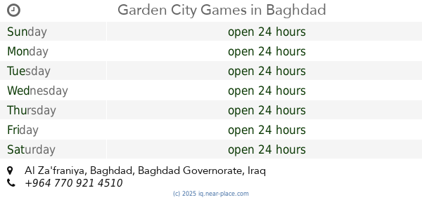
Garden City Games
Baghdad
Park
Amusement park
Point of interest
Establishment
read more
4.201 km
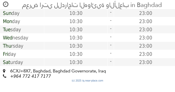
معرض ارتي للدراجات الهوائية والألعاب
6CXJ+8X7, Baghdad
Bicycle store
Point of interest
Store
Establishment
read more
4.593 km
Civil Defense Center in Diyala Bridge
6GH9+JVM, Jisr Diyala
Fire station
Point of interest
Establishment
read more
4.725 km
ركن الغيبة.
7F9M+G8C, Baghdad
Campground
Lodging
Park
Point of interest
Establishment
read more
6.376 km
فوج طوارئ المقر العام لمديرية شرطة الطاقة
7C78+CPW, الوزيرية الصناعية،، بغداد،, Baghdad
Police
Point of interest
Establishment
read more
📑
all categories
Accounting
Airport
Amusement park
Aquarium
Art gallery
Atm
Bakery
Bank
Bar
Beauty salon
Bicycle store
Book store
Bowling alley
Bus station
Cafe
Campground
Car dealer
Car rental
Car repair
Car wash
Casino
Cemetery
Church
City hall
Clothing store
Convenience store
Courthouse
Dentist
Department store
Doctor
Electrician
Electronics store
Embassy
Establishment
Finance
Fire station
Florist
Food
Funeral home
Furniture store
Gas station
General contractor
Grocery or supermarket
Gym
Hair care
Hardware store
Health
Hindu Temple
Home goods store
Hospital
Insurance agency
Jewelry store
Laundry
Lawyer
Library
Liquor store
Local government office
Locality
Locksmith
Lodging
Meal delivery
Meal takeaway
Mosque
Movie theater
Moving company
Museum
Neighborhood
Night club
Painter
Park
Parking
Pet store
Pharmacy
Physiotherapist
Place of worship
Plumber
Point of interest
Police
Political
Post office
Premise
Real estate agency
Restaurant
Roofing contractor
Route
Rv park, camping
School
Shoe store
Shopping mall
Spa
Stadium
Storage
Store
Sublocality
Supermarket
Synagogue
Taxi stand
Train station
Transit station
Travel agency
University
Veterinary care
Zoo
sublocality level 1
↑