Establishment nearby مطعم الدوره
Iraq
Establishment nearby مطعم الدوره
مطعم الدوره
Masafi Street, Baghdad, Al Rashid, IQ Iraq
contacts phone
:
+964
Latitude:
33.255359
, Longitude:
44.3699256
larger map & directions
read more
nearest Establishment
671 m
دائرة ضريبة السيدية
7927+RHC, Baghdad
Accounting
Finance
Local government office
Point of interest
Establishment
read more
713 m
قسم شرطة كهرباء الكرخ
794G+WW, Baghdad
Police
Point of interest
Establishment
read more
772 m
Saidiya fire department
7957+Q7G, 8, Baghdad
Fire station
Point of interest
Establishment
read more
885 m
مركز شرطه الدوره
794H+PP3, Baghdad
Police
Point of interest
Establishment
read more
1.22 km
Istanbul outfits
فلكة, شارع العلوة, Baghdad
Shopping mall
Clothing store
Store
Point of interest
Establishment
read more
1.223 km
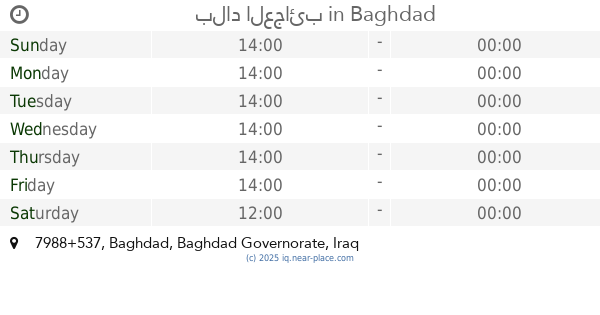
بلاد العجائب
7988+537, Baghdad
Amusement park
Point of interest
Establishment
read more
1.229 km
أحمد العراقي
69XJ+PCJ, Baghdad
Courthouse
Point of interest
Local government office
Establishment
read more
1.259 km
أعشاب وعطاريات الحكمة للطب البديل
793M+P88, Baghdad
Physiotherapist
Health
Point of interest
Establishment
read more
1.614 km
Aldora Garage Bus Stop
Al Ashyrians, Baghdad
Transit station
Point of interest
Establishment
read more
1.647 km
Enana Dental Clinic
7963+785, Baghdad
Doctor
Health
Point of interest
Establishment
read more
1.657 km
علي الجبوري تعديل و تزويد كافة الدراجات النارية
794Q+X2P, Baghdad
Bicycle store
Store
Point of interest
Establishment
read more
1.673 km
اني بودي
7963+H9Q, Tajari Street, Baghdad
Clothing store
Store
Point of interest
Establishment
read more
1.705 km
حلاقة علي السلطان
Unnamed Road Baghdad, Iraq🇮🇶
Hair care
Health
Point of interest
Establishment
read more
2.079 km
حمام بشوات بغداد فرع السيدية
7972+M4R, Baghdad
Spa
Point of interest
Establishment
read more
2.154 km
Paradies
787X+VQH, شارع قطر الندى, Baghdad
Campground
Lodging
Park
Point of interest
Establishment
read more
📑
all categories
Accounting
Airport
Amusement park
Aquarium
Art gallery
Atm
Bakery
Bank
Bar
Beauty salon
Bicycle store
Book store
Bowling alley
Bus station
Cafe
Campground
Car dealer
Car rental
Car repair
Car wash
Casino
Cemetery
Church
City hall
Clothing store
Convenience store
Courthouse
Dentist
Department store
Doctor
Electrician
Electronics store
Embassy
Establishment
Finance
Fire station
Florist
Food
Funeral home
Furniture store
Gas station
General contractor
Grocery or supermarket
Gym
Hair care
Hardware store
Health
Hindu Temple
Home goods store
Hospital
Insurance agency
Jewelry store
Laundry
Lawyer
Library
Liquor store
Local government office
Locality
Locksmith
Lodging
Meal delivery
Meal takeaway
Mosque
Movie theater
Moving company
Museum
Neighborhood
Night club
Painter
Park
Parking
Pet store
Pharmacy
Physiotherapist
Place of worship
Plumber
Point of interest
Police
Political
Post office
Premise
Real estate agency
Restaurant
Roofing contractor
Route
Rv park, camping
School
Shoe store
Shopping mall
Spa
Stadium
Storage
Store
Sublocality
Supermarket
Synagogue
Taxi stand
Train station
Transit station
Travel agency
University
Veterinary care
Zoo
sublocality level 1
↑