Establishment nearby ملجئ عمارات الالبان
Iraq
Establishment nearby ملجئ عمارات الالبان
ملجئ عمارات الالبان
857G+XHC، بغداد، 10081،، Al Anbar Governorate, 10081, Iraq
contacts phone
:
+964
Latitude:
33.3146281
, Longitude:
44.1761645
larger map & directions
read more
nearest Establishment
1.444 km
خيري للمشروبات الكحولية
854Q+828, Baghdad
Liquor store
Store
Point of interest
Establishment
read more
2.093 km
Hi Chicken Restaurant
شارع الزيتون بغداد, Abu Ghraib
Airport
Point of interest
Establishment
read more
2.221 km
محكمة ابي غريب
854X+V84, Baghdad
Courthouse
Local government office
Point of interest
Establishment
read more
3.09 km
Media College - Iraqi University
بالقرب من, بغداد
University
Point of interest
Establishment
read more
6.535 km
AWOS section
76FG+7CW, Baghdad
Airport
Point of interest
Establishment
read more
9.783 km
طرشي البركه
87JH+RQC, شارع النفلة, Baghdad
Restaurant
Food
Point of interest
Establishment
read more
10.282 km
ملعب الغزالية لخماسي الكرة
87PM+7H4, Baghdad
Stadium
Point of interest
Establishment
read more
12.083 km
شركة التاج لتأجير السيارات - فرع العامرية
8854+38J, Baghdad
Car rental
Point of interest
Establishment
read more
12.993 km
بيت بيوت
88J7+MR3, Baghdad
Night club
Point of interest
Establishment
read more
13.297 km
احمد سعد
7832+MC5, Baghdad
Campground
Lodging
Park
Point of interest
Establishment
read more
13.547 km
محلات السبطين
Baghdad
Bicycle store
Point of interest
Store
Establishment
read more
13.897 km
GIANT T.R
884G+F5R
Bicycle store
Point of interest
Store
Establishment
read more
13.992 km
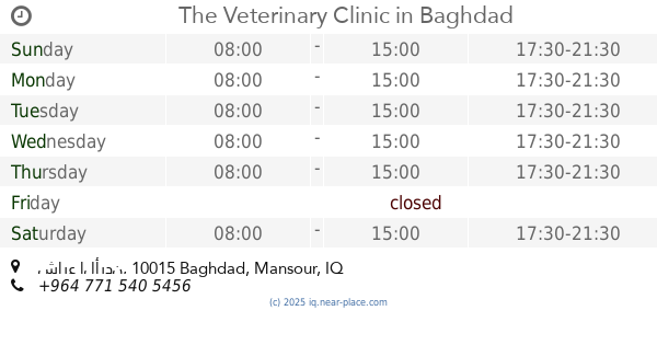
The Veterinary Clinic
الجامعة،, شارع الأردن, Baghdad
Veterinary care
Point of interest
Establishment
read more
15.208 km
قحطان الصفار لسمكره و صبغ وفحص صبغ السيارات
qahtan alsafar, Baghdad
Car repair
Point of interest
Establishment
read more
16.028 km
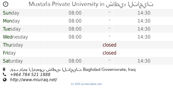
Mustafa Private University
قرب جامع المرهون, شاطيء التاجيات
University
Point of interest
Establishment
read more
📑
all categories
Accounting
Airport
Amusement park
Aquarium
Art gallery
Atm
Bakery
Bank
Bar
Beauty salon
Bicycle store
Book store
Bowling alley
Bus station
Cafe
Campground
Car dealer
Car rental
Car repair
Car wash
Casino
Cemetery
Church
City hall
Clothing store
Convenience store
Courthouse
Dentist
Department store
Doctor
Electrician
Electronics store
Embassy
Establishment
Finance
Fire station
Florist
Food
Funeral home
Furniture store
Gas station
General contractor
Grocery or supermarket
Gym
Hair care
Hardware store
Health
Hindu Temple
Home goods store
Hospital
Insurance agency
Jewelry store
Laundry
Lawyer
Library
Liquor store
Local government office
Locality
Locksmith
Lodging
Meal delivery
Meal takeaway
Mosque
Movie theater
Moving company
Museum
Neighborhood
Night club
Painter
Park
Parking
Pet store
Pharmacy
Physiotherapist
Place of worship
Plumber
Point of interest
Police
Political
Post office
Premise
Real estate agency
Restaurant
Roofing contractor
Route
Rv park, camping
School
Shoe store
Shopping mall
Spa
Stadium
Storage
Store
Sublocality
Supermarket
Synagogue
Taxi stand
Train station
Transit station
Travel agency
University
Veterinary care
Zoo
sublocality level 1
↑