Establishment nearby ملعب ام الطبول
Iraq
Establishment nearby ملعب ام الطبول
ملعب ام الطبول
78RV+2W2, Baghdad, Baghdad Governorate, Iraq
contacts phone
:
+964
Latitude:
33.2900045
, Longitude:
44.3447531
larger map & directions
read more
nearest Establishment
405 m
Alnawaris for Computer internet and Neo Credit
جامع بلال الحبشي, بغداد - حي القادسية - قرب, Baghdad
Electronics store
Store
Point of interest
Establishment
read more
427 m
مكتب المحامي مؤيد السعيدي
78RX+4PH، بغداد، بغداد
Lawyer
Point of interest
Establishment
read more
481 m
كماليات ياسر وسامر وسيف
مجاور عصير كيوي, اربع شوارع, Baghdad
Car wash
Point of interest
Establishment
read more
530 m
تولي للزهور و الهدايا
882P+VP8, 4 شوارع, Baghdad
Florist
Store
Point of interest
Establishment
read more
532 m
غسيل الكرم
78PX+HHJ, Baghdad
Car wash
Point of interest
Establishment
read more
557 m
عيادة شوكا و روزة البيطرية/ دكتورة اسيل
13 Qadisaya Expressway, Baghdad
Veterinary care
Point of interest
Establishment
read more
744 m
بدايه شارع المطار
78PP+WXF, Airport Street, Baghdad
Police
Point of interest
Establishment
read more
750 m
titans gym
79R3+G3M, Jinub Street, Baghdad
Gym
Point of interest
Health
Establishment
read more
786 m
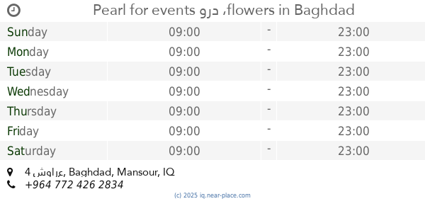
Pearl for events ورد ،flowers
Yarmuk Street, 4 شوارع, Baghdad
Florist
Store
Point of interest
Establishment
read more
798 m
SIZIGY BURGERCLUB
Baghdad
Meal takeaway
Restaurant
Food
Point of interest
Establishment
read more
806 m
DsdLab
8H5679Q3+36, Baghdad
Health
Insurance agency
Point of interest
Establishment
read more
981 m
شركة مسار الامراء لتجارة السيارات
78XR+79W
Moving company
Point of interest
Establishment
read more
1.006 km
عيادة محطة الحيوان البيطرية
79W3+92F, Jinub Street, Baghdad
Veterinary care
Point of interest
Establishment
read more
1.058 km
زهور سيلفا 2
78XR+F4V, Yarmuk Street, Baghdad
Florist
Store
Point of interest
Establishment
read more
1.287 km
خدمات وسام المجد
78XM+6XR, 4 شوارع, Baghdad
Car wash
Point of interest
Establishment
read more
📑
all categories
Accounting
Airport
Amusement park
Aquarium
Art gallery
Atm
Bakery
Bank
Bar
Beauty salon
Bicycle store
Book store
Bowling alley
Bus station
Cafe
Campground
Car dealer
Car rental
Car repair
Car wash
Casino
Cemetery
Church
City hall
Clothing store
Convenience store
Courthouse
Dentist
Department store
Doctor
Electrician
Electronics store
Embassy
Establishment
Finance
Fire station
Florist
Food
Funeral home
Furniture store
Gas station
General contractor
Grocery or supermarket
Gym
Hair care
Hardware store
Health
Hindu Temple
Home goods store
Hospital
Insurance agency
Jewelry store
Laundry
Lawyer
Library
Liquor store
Local government office
Locality
Locksmith
Lodging
Meal delivery
Meal takeaway
Mosque
Movie theater
Moving company
Museum
Neighborhood
Night club
Painter
Park
Parking
Pet store
Pharmacy
Physiotherapist
Place of worship
Plumber
Point of interest
Police
Political
Post office
Premise
Real estate agency
Restaurant
Roofing contractor
Route
Rv park, camping
School
Shoe store
Shopping mall
Spa
Stadium
Storage
Store
Sublocality
Supermarket
Synagogue
Taxi stand
Train station
Transit station
Travel agency
University
Veterinary care
Zoo
sublocality level 1
↑