Establishment nearby مجمع الزهراء الطبي
Iraq
Establishment nearby مجمع الزهراء الطبي
مجمع الزهراء الطبي
R4F8+5P2, Amarah, Maysan Governorate, Iraq
contacts phone
:
+964 776 370 0472
Latitude:
31.8229544
, Longitude:
47.1167719
larger map & directions
read more
nearest Establishment
333 m
صيدليه ساره صلاح
R4G8+CQ2, Amarah
Hospital
Health
Point of interest
Establishment
read more
466 m
عياداد دوائي
R4G8+VQP، العمارة،
Dentist
Health
Point of interest
Establishment
read more
698 m
صيدليه التجميل الاسنان
R49C+RRJ، العمارة،، العمارة،
Dentist
Health
Point of interest
Establishment
read more
742 m
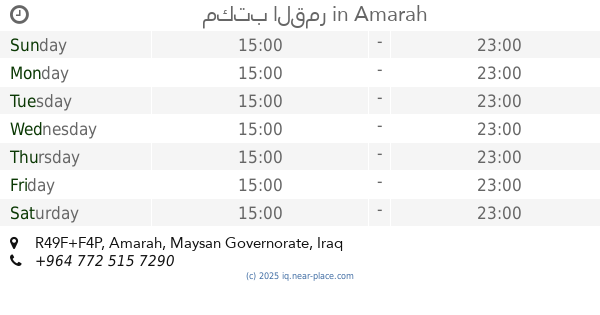
مكتب القمر
R49F+F4P, Amarah
Post office
Finance
Point of interest
Establishment
read more
909 m
صيدليه بوادر الخير
خلف الملعب قرب اسواق المصطفى, ميسان
Hospital
Health
Point of interest
Establishment
read more
919 m
عيادة بريتاو لطب الأسنان
اسواق المصطفى, ميسان /العماره / قرب
Dentist
Health
Point of interest
Establishment
read more
1.063 km
صيدلية المنتظر
R4M8+4V4, Amarah
Hospital
Health
Point of interest
Establishment
read more
1.719 km
Advisory clinic in the letter neighborhood
R4GM+9V2, طريق ناصرية - عمارة, العمارة
Hospital
Health
Point of interest
Establishment
read more
1.898 km
بدر عبد الحسن داود
R4JM+4FX، العمارة،
Lodging
Point of interest
Establishment
read more
2.03 km
كاظم مهدي
R4QH+88P, طريق عمارة - ديوانية, Amarah
Lodging
Point of interest
Establishment
read more
2.05 km
حيدر ابو كنان
Amarah
Lodging
Point of interest
Establishment
read more
2.152 km
ماكولات نوارس ميسان
R4MM+RXX, العمارة
Restaurant
Point of interest
Food
Establishment
read more
2.182 km
ماركت غزوان الكحلاوي
R4JP+QWV, Amarah
Supermarket
Grocery or supermarket
Food
Store
Point of interest
Establishment
read more
2.513 km
اسواق فستقة
R4RM+2J6, Amarah
Supermarket
Grocery or supermarket
Food
Store
Point of interest
Establishment
read more
2.651 km
القطاع
R4RP+C8R, Amarah
Supermarket
Grocery or supermarket
Store
Point of interest
Food
Establishment
read more
📑
all categories
Accounting
Airport
Amusement park
Aquarium
Art gallery
Atm
Bakery
Bank
Bar
Beauty salon
Bicycle store
Book store
Bowling alley
Bus station
Cafe
Campground
Car dealer
Car rental
Car repair
Car wash
Casino
Cemetery
Church
City hall
Clothing store
Convenience store
Courthouse
Dentist
Department store
Doctor
Electrician
Electronics store
Embassy
Establishment
Finance
Fire station
Florist
Food
Funeral home
Furniture store
Gas station
General contractor
Grocery or supermarket
Gym
Hair care
Hardware store
Health
Hindu Temple
Home goods store
Hospital
Insurance agency
Jewelry store
Laundry
Lawyer
Library
Liquor store
Local government office
Locality
Locksmith
Lodging
Meal delivery
Meal takeaway
Mosque
Movie theater
Moving company
Museum
Neighborhood
Night club
Painter
Park
Parking
Pet store
Pharmacy
Physiotherapist
Place of worship
Plumber
Point of interest
Police
Political
Post office
Premise
Real estate agency
Restaurant
Roofing contractor
Route
Rv park, camping
School
Shoe store
Shopping mall
Spa
Stadium
Storage
Store
Sublocality
Supermarket
Synagogue
Taxi stand
Train station
Transit station
Travel agency
University
Veterinary care
Zoo
sublocality level 1
↑