Establishment nearby مديرية الدفاع المدني الكرخ
Iraq
Establishment nearby مديرية الدفاع المدني الكرخ
مديرية الدفاع المدني الكرخ
مديرية دفاع المدني الكرخ، Baghdad, Baghdad Governorate, Iraq
contacts phone
:
+964
Latitude:
33.3155518
, Longitude:
44.3317862
larger map & directions
read more
nearest Establishment
346 m
Puro lounge
889J+947, Baghdad
Night club
Bar
Point of interest
Establishment
read more
346 m
12hrs Laundry
887J+252, Baghdad
Laundry
Point of interest
Establishment
read more
527 m
Hay Al-Jamia Gas Station
887G+RFQ, Baghdad
Gas station
Point of interest
Establishment
read more
527 m
Speed Car Wash
889J+X2X, Baghdad
Car wash
Point of interest
Establishment
read more
608 m
Tabbaa Kitchens iraq
888Q+98P, 14 Ramadan Street, Baghdad
Home goods store
Store
Point of interest
Establishment
read more
608 m
Ice Pack
887Q+W8C, Arbataash (14th) Ramadan Street, Baghdad
Cafe
Food
Point of interest
Establishment
read more
619 m
زهور دندش
شارع 14 رمضان،
Florist
Store
Point of interest
Establishment
read more
623 m
فازة ورد | vase rose
14 Ramadan Street, Baghdad
Florist
Store
Point of interest
Establishment
read more
839 m
شركة أثر للاستشارات المالية والمحاسبية والضريبية
889Q+JWR, Baghdad
Accounting
Finance
Point of interest
Establishment
read more
904 m
رحمون للهندسة الكهربائيات
88CQ+9JM، بغداد،،
Electrician
Point of interest
Establishment
read more
947 m
مكتب الساعة للعقار
88CQ+PC, Baghdad
Real estate agency
Point of interest
Establishment
read more
961 m
Sophilia Flowers Shop
88CF+PR9, الجامعة،, Baghdad
Florist
Store
Point of interest
Establishment
read more
963 m
Dr. Mohammed mahdi alsaadi
14 ramadan /squads 607 - St 55 H 7 Baghdad Al, almansur
Dentist
Health
Point of interest
Establishment
read more
1.012 km
عيادة توم وجيري البيطرية
889R+3WX, Baghdad
Pharmacy
Veterinary care
Health
Store
Point of interest
Establishment
read more
1.108 km
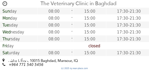
The Veterinary Clinic
الجامعة،, شارع الأردن, Baghdad
Veterinary care
Point of interest
Establishment
read more
📑
all categories
Accounting
Airport
Amusement park
Aquarium
Art gallery
Atm
Bakery
Bank
Bar
Beauty salon
Bicycle store
Book store
Bowling alley
Bus station
Cafe
Campground
Car dealer
Car rental
Car repair
Car wash
Casino
Cemetery
Church
City hall
Clothing store
Convenience store
Courthouse
Dentist
Department store
Doctor
Electrician
Electronics store
Embassy
Establishment
Finance
Fire station
Florist
Food
Funeral home
Furniture store
Gas station
General contractor
Grocery or supermarket
Gym
Hair care
Hardware store
Health
Hindu Temple
Home goods store
Hospital
Insurance agency
Jewelry store
Laundry
Lawyer
Library
Liquor store
Local government office
Locality
Locksmith
Lodging
Meal delivery
Meal takeaway
Mosque
Movie theater
Moving company
Museum
Neighborhood
Night club
Painter
Park
Parking
Pet store
Pharmacy
Physiotherapist
Place of worship
Plumber
Point of interest
Police
Political
Post office
Premise
Real estate agency
Restaurant
Roofing contractor
Route
Rv park, camping
School
Shoe store
Shopping mall
Spa
Stadium
Storage
Store
Sublocality
Supermarket
Synagogue
Taxi stand
Train station
Transit station
Travel agency
University
Veterinary care
Zoo
sublocality level 1
↑