Establishment nearby مدرسة ٦ كانون الابتدائية للبنين
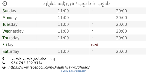
Iraq
Establishment nearby مدرسة ٦ كانون الابتدائية للبنين
مدرسة ٦ كانون الابتدائية للبنين
68P4+63C, Baghdad, Baghdad Governorate, Iraq
contacts phone
:
+964 790 174 1772
website:
www.facebook.com
Latitude:
33.2355602
, Longitude:
44.3051523
larger map & directions
read more
nearest Establishment
508 m
Msadjadalkhalafa adults
68J4+CFC, Baghdad
Mosque
Place of worship
Point of interest
Establishment
read more
519 m
مدرسة اهل الحق الأبتدائية
68J2+HXV, Baghdad
School
Point of interest
Establishment
read more
561 m
Imam Ali mosque, peace be upon him
68J2+R8G, Baghdad
Mosque
Place of worship
Point of interest
Establishment
read more
814 m
Msadjadalamam Hassan Mujtaba
68H2+GMP, Baghdad
Mosque
Place of worship
Point of interest
Establishment
read more
816 m
دراجات هوائية / بغداد
اا, بغداد
Bicycle store
Store
Point of interest
Establishment
read more
935 m
thank you thank you
68Q7+MMH, Baghdad
Hair care
Point of interest
Establishment
read more
1.202 km
حسين اسعد
68W3+G93, Unnamed Road, Baghdad
Meal delivery
Food
Point of interest
Establishment
read more
1.765 km
حلويات ومعجنات زينب
شارع الضغط, Baghdad
Bakery
Store
Food
Point of interest
Establishment
read more
1.988 km
Abu Ali al-Maliki markets
7833+9H8, Baghdad
Shopping mall
Point of interest
Establishment
read more
2.069 km
مكتب مهند ستلايت
7837+645, Baghdad
Art gallery
Point of interest
Establishment
read more
2.229 km
احمد سعد
7832+MC5, Baghdad
Campground
Lodging
Park
Point of interest
Establishment
read more
2.326 km
مجمع الجود الطبي
شارع الرافدين, بغداد
Spa
Health
Point of interest
Establishment
read more
2.621 km
مطعم علي الياباني Y
775W+49W, Baghdad
Meal takeaway
Restaurant
Food
Point of interest
Establishment
read more
2.861 km
اسماك حجي علي عوفي
68WM+F7M, شارع قطر الندى, Baghdad
Meal takeaway
Restaurant
Food
Point of interest
Establishment
read more
3.13 km
مكان حلاق الرحمه
775Q+X73, Baghdad
Night club
Point of interest
Establishment
read more
📑
all categories
Accounting
Airport
Amusement park
Aquarium
Art gallery
Atm
Bakery
Bank
Bar
Beauty salon
Bicycle store
Book store
Bowling alley
Bus station
Cafe
Campground
Car dealer
Car rental
Car repair
Car wash
Casino
Cemetery
Church
City hall
Clothing store
Convenience store
Courthouse
Dentist
Department store
Doctor
Electrician
Electronics store
Embassy
Establishment
Finance
Fire station
Florist
Food
Funeral home
Furniture store
Gas station
General contractor
Grocery or supermarket
Gym
Hair care
Hardware store
Health
Hindu Temple
Home goods store
Hospital
Insurance agency
Jewelry store
Laundry
Lawyer
Library
Liquor store
Local government office
Locality
Locksmith
Lodging
Meal delivery
Meal takeaway
Mosque
Movie theater
Moving company
Museum
Neighborhood
Night club
Painter
Park
Parking
Pet store
Pharmacy
Physiotherapist
Place of worship
Plumber
Point of interest
Police
Political
Post office
Premise
Real estate agency
Restaurant
Roofing contractor
Route
Rv park, camping
School
Shoe store
Shopping mall
Spa
Stadium
Storage
Store
Sublocality
Supermarket
Synagogue
Taxi stand
Train station
Transit station
Travel agency
University
Veterinary care
Zoo
sublocality level 1
↑