Establishment nearby مأكولات اركان
Iraq
Establishment nearby مأكولات اركان
مأكولات اركان
F9CF+PM7 شارع ساحه الطيران، كركوك، كركوك محافظة، 36001, Iraq
contacts phone
:
+964 770 096 4016
Latitude:
35.4717811
, Longitude:
44.3741679
larger map & directions
read more
nearest Establishment
753 m
Berry_Caffe
F9GH+QRQ, Shari Almas, Kirkuk
Cafe
Food
Point of interest
Store
Establishment
read more
772 m
حي الحجاج شارع الأطباء
F98H+MX2, Kirkuk
Restaurant
Food
Point of interest
Establishment
read more
772 m
ماركت نياز
F98H+MX2, Kirkuk
Supermarket
Grocery or supermarket
Store
Food
Point of interest
Establishment
read more
772 m
كافتريا فيسبوك
F98H+MX2, Kirkuk
Cafe
Food
Point of interest
Establishment
read more
772 m
اسواق حجي سلام واخوانه
F98H+MX2, Kirkuk
Supermarket
Point of interest
Grocery or supermarket
Store
Food
Establishment
read more
772 m
حوریە
F98H+MX2, Kirkuk
Lodging
Point of interest
Establishment
read more
772 m
أسواق المنير
F98H+MX2, Kirkuk
Supermarket
Grocery or supermarket
Store
Food
Point of interest
Establishment
read more
772 m
طريق الی مرطبات كهور دی
F98H+MX2, كركوك
Cafe
Point of interest
Store
Food
Establishment
read more
792 m
Al-Rahma Medical Center کۆمەڵگەی پزیشکی ڕەحمە
F9FJ+HXQ, Kirkuk
Hospital
Health
Point of interest
Establishment
read more
861 m
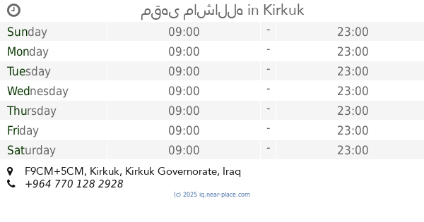
مقهى ماشالله
F9CM+5CM, Kirkuk
Cafe
Food
Point of interest
Establishment
read more
866 m
قاپوتەکان
F9CM+6C8, Kirkuk
Cafe
Food
Point of interest
Establishment
read more
879 m
انس الطائي للاسماك المقلية والمسگوف
F9CM+3CX, Kirkuk
Restaurant
Point of interest
Food
Establishment
read more
988 m
مجمع المنصور الطبي
F9GM+3MH, Kirkuk
Hospital
Point of interest
Health
Establishment
read more
1.024 km
مجمع الكريم الطبي
F9FM+WWP, Kirkuk
Hospital
Point of interest
Health
Establishment
read more
1.044 km
عيادة د. سركون يوئيل إيليا
F9GM+3X3
Dentist
Point of interest
Health
Establishment
read more
📑
all categories
Accounting
Airport
Amusement park
Aquarium
Art gallery
Atm
Bakery
Bank
Bar
Beauty salon
Bicycle store
Book store
Bowling alley
Bus station
Cafe
Campground
Car dealer
Car rental
Car repair
Car wash
Casino
Cemetery
Church
City hall
Clothing store
Convenience store
Courthouse
Dentist
Department store
Doctor
Electrician
Electronics store
Embassy
Establishment
Finance
Fire station
Florist
Food
Funeral home
Furniture store
Gas station
General contractor
Grocery or supermarket
Gym
Hair care
Hardware store
Health
Hindu Temple
Home goods store
Hospital
Insurance agency
Jewelry store
Laundry
Lawyer
Library
Liquor store
Local government office
Locality
Locksmith
Lodging
Meal delivery
Meal takeaway
Mosque
Movie theater
Moving company
Museum
Neighborhood
Night club
Painter
Park
Parking
Pet store
Pharmacy
Physiotherapist
Place of worship
Plumber
Point of interest
Police
Political
Post office
Premise
Real estate agency
Restaurant
Roofing contractor
Route
Rv park, camping
School
Shoe store
Shopping mall
Spa
Stadium
Storage
Store
Sublocality
Supermarket
Synagogue
Taxi stand
Train station
Transit station
Travel agency
University
Veterinary care
Zoo
sublocality level 1
↑