Establishment nearby فريش اليرموك
Iraq
Establishment nearby فريش اليرموك
فريش اليرموك
78XR+238, Baghdad, Baghdad Governorate, Iraq
contacts phone
:
+964
Latitude:
33.2975254
, Longitude:
44.3402108
larger map & directions
read more
nearest Establishment
137 m
زهور سيلفا 2
78XR+F4V, Yarmuk Street, Baghdad
Florist
Store
Point of interest
Establishment
read more
320 m
Square lounge
78XV+R62, Baghdad
Bar
Point of interest
Establishment
read more
574 m
LUNA by WOLF
616 Yarmuk Street, Baghdad
Gym
Point of interest
Health
Establishment
read more
737 m
Rose station زهور وكافي محطة الورود
882M+QPF, Baghdad
Florist
Store
Point of interest
Establishment
read more
792 m
Police office
Yarmouk Clinic, Baghdad
Police
Point of interest
Establishment
read more
824 m
AMH Nutrition Company
Al Kuwait Building, Urdun Street, Baghdad
Gym
Point of interest
Health
Establishment
read more
839 m
شركة البشرى للتوصيل السريع والنقل العام
883V+QGJ, شارع الاميرات، بغداد،, Baghdad
Post office
Finance
Point of interest
Establishment
read more
861 m
مركز حجامة الرحمة
883W+2VH, اليرموك، بغداد،, Baghdad
Physiotherapist
Health
Point of interest
Establishment
read more
885 m
الفصول الاربعة
882X+GCH, Baghdad
Convenience store
Store
Food
Point of interest
Establishment
read more
895 m
كماليات ياسر وسامر وسيف
مجاور عصير كيوي, اربع شوارع, Baghdad
Car wash
Point of interest
Establishment
read more
954 m
گاليري مجيد - Majeed Art Gallery
Select a State/Province, Baghdad
Art gallery
Point of interest
Establishment
read more
985 m
شركه الفهد لتأجير السيارات
88GV+5Q, Baghdad
Car rental
Point of interest
Establishment
read more
988 m
Yarmouk Traffic Directorate
883X+69Q, شارع بيروت, Baghdad
Police
Point of interest
Establishment
read more
1.015 km
عيادة الداودي البيطرية
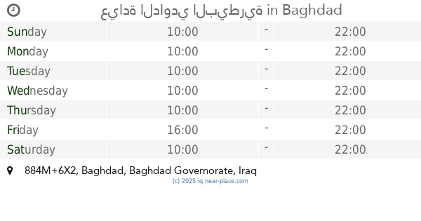
884M+6X2, Baghdad
Veterinary care
Point of interest
Establishment
read more
1.135 km
St. Joseph Church
884W+CQF, Baghdad
Church
Place of worship
Point of interest
Establishment
read more
📑
all categories
Accounting
Airport
Amusement park
Aquarium
Art gallery
Atm
Bakery
Bank
Bar
Beauty salon
Bicycle store
Book store
Bowling alley
Bus station
Cafe
Campground
Car dealer
Car rental
Car repair
Car wash
Casino
Cemetery
Church
City hall
Clothing store
Convenience store
Courthouse
Dentist
Department store
Doctor
Electrician
Electronics store
Embassy
Establishment
Finance
Fire station
Florist
Food
Funeral home
Furniture store
Gas station
General contractor
Grocery or supermarket
Gym
Hair care
Hardware store
Health
Hindu Temple
Home goods store
Hospital
Insurance agency
Jewelry store
Laundry
Lawyer
Library
Liquor store
Local government office
Locality
Locksmith
Lodging
Meal delivery
Meal takeaway
Mosque
Movie theater
Moving company
Museum
Neighborhood
Night club
Painter
Park
Parking
Pet store
Pharmacy
Physiotherapist
Place of worship
Plumber
Point of interest
Police
Political
Post office
Premise
Real estate agency
Restaurant
Roofing contractor
Route
Rv park, camping
School
Shoe store
Shopping mall
Spa
Stadium
Storage
Store
Sublocality
Supermarket
Synagogue
Taxi stand
Train station
Transit station
Travel agency
University
Veterinary care
Zoo
sublocality level 1
↑