Establishment nearby Embassy of Republic of Sudan
Iraq
Establishment nearby Embassy of Republic of Sudan
Embassy of Republic of Sudan
78V6+V3M, Baghdad, Baghdad Governorate, Iraq
contacts phone
:
+964
website:
sudanembassy-iq.com
Latitude:
33.2947166
, Longitude:
44.3101781
larger map & directions
read more
nearest Establishment
118 m
السفارة الموريتانية Mauritanian Embassy
78V6+RHW, Baghdad
Embassy
Point of interest
Establishment
read more
858 m
Bulgarian Embassy Abandoned
78W9+5PH, Safarat Street, Baghdad
Embassy
Point of interest
Establishment
read more
965 m
مركز كماليات الدراجات
77VX+HXJ, Baghdad
Bicycle store
Store
Point of interest
Establishment
read more
973 m
الفچهنه
8828+MJ2, Baghdad
Church
Place of worship
Point of interest
Establishment
read more
973 m
Kuwait Embassy before 1990
78VC+V7C
Embassy
Point of interest
Establishment
read more
1.094 km
معهد نسمة الامل
78X2+V2C, Baghdad
Physiotherapist
Health
Point of interest
Establishment
read more
1.094 km
شركة اركداش للسفر والسياحة
78X2+V2C, Baghdad
Moving company
Point of interest
Establishment
read more
1.095 km
معبد البلابل
78X2+V2C, Baghdad
Hindu Temple
Place of worship
Point of interest
Establishment
read more
1.104 km
مركز نسمة أمل للعلاج الطبيعي العامرية
8822+QQH, شارع المنظمة, Baghdad
Physiotherapist
Point of interest
Health
Establishment
read more
1.552 km
شركة التاج لتأجير السيارات - فرع العامرية
8854+38J, Baghdad
Car rental
Point of interest
Establishment
read more
1.601 km
Mar Yousif Chaldean Catholic Church
883F+8HQ, Baghdad
Church
Place of worship
Point of interest
Establishment
read more
1.631 km
Aleef House اليف هاوس
قرب كنيسة مار يوسف, نفق الشرطة, Baghdad
Pet store
Store
Point of interest
Establishment
read more
1.909 km
GIANT T.R
884G+F5R
Bicycle store
Point of interest
Store
Establishment
read more
2.011 km
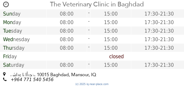
The Veterinary Clinic
الجامعة،, شارع الأردن, Baghdad
Veterinary care
Point of interest
Establishment
read more
2.054 km
Clover
885F+JJH, Rabie Street, Baghdad
Florist
Store
Point of interest
Establishment
read more
📑
all categories
Accounting
Airport
Amusement park
Aquarium
Art gallery
Atm
Bakery
Bank
Bar
Beauty salon
Bicycle store
Book store
Bowling alley
Bus station
Cafe
Campground
Car dealer
Car rental
Car repair
Car wash
Casino
Cemetery
Church
City hall
Clothing store
Convenience store
Courthouse
Dentist
Department store
Doctor
Electrician
Electronics store
Embassy
Establishment
Finance
Fire station
Florist
Food
Funeral home
Furniture store
Gas station
General contractor
Grocery or supermarket
Gym
Hair care
Hardware store
Health
Hindu Temple
Home goods store
Hospital
Insurance agency
Jewelry store
Laundry
Lawyer
Library
Liquor store
Local government office
Locality
Locksmith
Lodging
Meal delivery
Meal takeaway
Mosque
Movie theater
Moving company
Museum
Neighborhood
Night club
Painter
Park
Parking
Pet store
Pharmacy
Physiotherapist
Place of worship
Plumber
Point of interest
Police
Political
Post office
Premise
Real estate agency
Restaurant
Roofing contractor
Route
Rv park, camping
School
Shoe store
Shopping mall
Spa
Stadium
Storage
Store
Sublocality
Supermarket
Synagogue
Taxi stand
Train station
Transit station
Travel agency
University
Veterinary care
Zoo
sublocality level 1
↑