Establishment nearby العراق محافظة النجف
Iraq
Establishment nearby العراق محافظة النجف
العراق محافظة النجف
28FR+2F5, Najaf, Najaf Governorate, Iraq
contacts phone
:
+964
Latitude:
32.0225245
, Longitude:
44.3412395
larger map & directions
read more
nearest Establishment
166 m
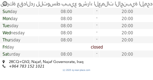
شركة عقدالدر للتوسط ببيع وشراء العملات الاجنبية المحدودة
28CQ+QV2, Najaf
Bank
Finance
Point of interest
Establishment
read more
555 m
دكتورة زهراء المالكي
28GV+QHH, Unnamed Road, النجف
Dentist
Health
Point of interest
Establishment
read more
586 m
عيادة الدكتور ستار الحميدات
28CP+469, Najaf
Dentist
Health
Point of interest
Establishment
read more
660 m
مكتب الاستاذ ضرغام الملك
28CX+858, Najaf
Post office
Finance
Point of interest
Establishment
read more
752 m
عيادة سوليتير لطب الاسنان والتجميل
حي الغري, شارع العين, Najaf
Dentist
Health
Point of interest
Establishment
read more
795 m
كوزمتك للاسنان
28HP+GWX, السلام،, Najaf
Dentist
Health
Point of interest
Establishment
read more
804 m
عيادة كريستالة
مركز صحي ميسان القديم, الكوفه حي ميسان _مقاب
Dentist
Health
Point of interest
Establishment
read more
852 m
عيادة العريش لطب الاسنان
28GM+VJ2, شارع العين, Najaf
Dentist
Health
Point of interest
Establishment
read more
962 m
سوبر ماركت وفر
الحزام الاخضر, النجف
Supermarket
Grocery or supermarket
Store
Food
Point of interest
Establishment
read more
962 m
عيادة ريماس التخصصية لطب وتجميل الاسنان
28CJ+FF5, Najaf
Dentist
Health
Point of interest
Establishment
read more
977 m
مقهى ريحانه
28CJ+J9V, Najaf
Cafe
Store
Food
Point of interest
Establishment
read more
1.001 km
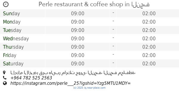
Perle restaurant & coffee shop
الحزام الاخضر قرب هايبر ماركت جوري, النجف
Restaurant
Cafe
Food
Store
Point of interest
Establishment
read more
1.005 km
JANAH SUPERMARKET
288M+5V4, Najaf
Supermarket
Grocery or supermarket
Store
Food
Point of interest
Establishment
read more
1.073 km
كافيةالتلال
288J+VG, Najaf
Cafe
Food
Point of interest
Store
Establishment
read more
1.14 km
مطعم وكافية كلكسي
288J+VG, Najaf
Store
Cafe
Point of interest
Food
Establishment
read more
📑
all categories
Accounting
Airport
Amusement park
Aquarium
Art gallery
Atm
Bakery
Bank
Bar
Beauty salon
Bicycle store
Book store
Bowling alley
Bus station
Cafe
Campground
Car dealer
Car rental
Car repair
Car wash
Casino
Cemetery
Church
City hall
Clothing store
Convenience store
Courthouse
Dentist
Department store
Doctor
Electrician
Electronics store
Embassy
Establishment
Finance
Fire station
Florist
Food
Funeral home
Furniture store
Gas station
General contractor
Grocery or supermarket
Gym
Hair care
Hardware store
Health
Hindu Temple
Home goods store
Hospital
Insurance agency
Jewelry store
Laundry
Lawyer
Library
Liquor store
Local government office
Locality
Locksmith
Lodging
Meal delivery
Meal takeaway
Mosque
Movie theater
Moving company
Museum
Neighborhood
Night club
Painter
Park
Parking
Pet store
Pharmacy
Physiotherapist
Place of worship
Plumber
Point of interest
Police
Political
Post office
Premise
Real estate agency
Restaurant
Roofing contractor
Route
Rv park, camping
School
Shoe store
Shopping mall
Spa
Stadium
Storage
Store
Sublocality
Supermarket
Synagogue
Taxi stand
Train station
Transit station
Travel agency
University
Veterinary care
Zoo
sublocality level 1
↑