Hospital nearby Al Razi Health Center
Iraq
Hospital nearby Al Razi Health Center
Al Razi Health Center
شارع النبي ابراهيم ع, الناصرية, ناصرية, IQ Iraq
contacts phone
:
+964
Latitude:
31.0485037
, Longitude:
46.2600347
larger map & directions
read more
nearest Hospital
383 m
صيدلية اغادير
27X4+XJ6, Nasiriyah
Hospital
Health
Point of interest
Establishment
read more
410 m
دكتوره سحاب اختصاص اطفال وحديث الولاده
3724+CQ7, Nasiriyah
Hospital
Health
Point of interest
Establishment
read more
410 m
موكب قادة الامم الحسيني
3724+CQ7, Nasiriyah
Hospital
Health
Point of interest
Establishment
read more
665 m
د. هيفاء العكيلي للاسنان
27W3+4JX, Nasiriyah
Hospital
Health
Point of interest
Establishment
read more
675 m
Laboratory analyzes of the Shatt al-Arab pathological
27W3+9CH, Nile Street, Nasiriyah
Hospital
Health
Point of interest
Establishment
read more
699 m
بيت سلام آل سالم
3738+457, Nasiriyah
Hospital
Health
Point of interest
Establishment
read more
706 m
مركز الدكتور ياسين الغزي للسمع والتوازن والنطق
فرع مكاتب العقارات, شارع الحبوبي, An Nasiriyah
Hospital
Health
Point of interest
Establishment
read more
744 m
المختبر المركزي
27W3+66V, Nasiriyah
Hospital
Health
Point of interest
Establishment
read more
841 m
مركز صحي الشهيد محمد قاسم
الصالحيه
Hospital
Health
Point of interest
Establishment
read more
895 m
Umm Al Baneen Health Centre.
27R5+5PW, شارع الجمهورية, An Nasiriyah
Hospital
Health
Point of interest
Establishment
read more
942 m
مستشفى محمد الموسوي للأطفال
27X2+43V, Nasiriyah
Hospital
Health
Point of interest
Establishment
read more
958 m
مستشفى الحضارات الاستثماري
27V2+JH7, Nasiriyah
Hospital
Health
Point of interest
Establishment
read more
958 m
مستشفى الحضارات الاهلي
27V2+FJV, Nasiriyah
Hospital
Health
Point of interest
Establishment
read more
960 m
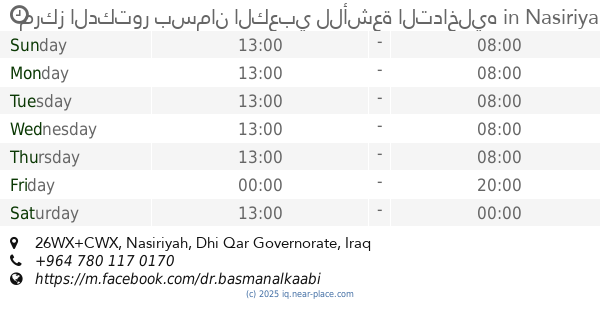
مركز الدكتور بسمان الكعبي للأشعة التداخليه
26WX+CWX, Nasiriyah
Hospital
Health
Point of interest
Establishment
read more
980 m
مركز التميز للتشخيص الطبي
27V2+GG5, Nasiriyah
Hospital
Health
Point of interest
Establishment
read more
📑
all categories
Accounting
Airport
Amusement park
Aquarium
Art gallery
Atm
Bakery
Bank
Bar
Beauty salon
Bicycle store
Book store
Bowling alley
Bus station
Cafe
Campground
Car dealer
Car rental
Car repair
Car wash
Casino
Cemetery
Church
City hall
Clothing store
Convenience store
Courthouse
Dentist
Department store
Doctor
Electrician
Electronics store
Embassy
Establishment
Finance
Fire station
Florist
Food
Funeral home
Furniture store
Gas station
General contractor
Grocery or supermarket
Gym
Hair care
Hardware store
Health
Hindu Temple
Home goods store
Hospital
Insurance agency
Jewelry store
Laundry
Lawyer
Library
Liquor store
Local government office
Locality
Locksmith
Lodging
Meal delivery
Meal takeaway
Mosque
Movie theater
Moving company
Museum
Neighborhood
Night club
Painter
Park
Parking
Pet store
Pharmacy
Physiotherapist
Place of worship
Plumber
Point of interest
Police
Political
Post office
Premise
Real estate agency
Restaurant
Roofing contractor
Route
Rv park, camping
School
Shoe store
Shopping mall
Spa
Stadium
Storage
Store
Sublocality
Supermarket
Synagogue
Taxi stand
Train station
Transit station
Travel agency
University
Veterinary care
Zoo
sublocality level 1
↑