Finance nearby شركة طريق المسرة للصرافة
Iraq
Finance nearby شركة طريق المسرة للصرافة
شركة طريق المسرة للصرافة
X8W9+HGP, Najaf, Najaf Governorate, Iraq
contacts phone
:
+964
Latitude:
31.9964536
, Longitude:
44.3188424
larger map & directions
read more
nearest Finance
178 m
Rafidain Bank, No. 7
X8WC+J7Q, Najaf
Bank
Finance
Point of interest
Establishment
read more
196 m
شركة الاستبراق
X8V9+VHG, شارع الخورنق, Najaf
Bank
Finance
Point of interest
Establishment
read more
213 m
صراف البنك العراقي للتجاره TBI atm
X8W8+PJ3, Najaf
Bank
Finance
Point of interest
Establishment
read more
214 m
Agricultural Cooperative Bank
عمارة الحياة, Najaf
Bank
Finance
Point of interest
Establishment
read more
218 m
صراف آلي دولي
X8W8+PJ3, المشراق،, Najaf
Atm
Finance
Point of interest
Establishment
read more
406 m
منفذ ميران لصرف البطاقه الذكيه
X8VC+648, شارع بنات الحسن (ع, Najaf
Bank
Finance
Point of interest
Establishment
read more
555 m
مكتب ولادات ووفيات النجف
X8RC+WVW, Najaf
Post office
Finance
Point of interest
Establishment
read more
810 m
الرشيد
X8VG+4F5, شارع المدينة, Najaf
Bank
Finance
Point of interest
Establishment
read more
908 m
IDB ATM
X8V5+PRV, Najaf
Atm
Finance
Point of interest
Establishment
read more
1.011 km
شركة الياس للصرافة
X8VH+JJQ, شارع المدينة, Najaf
Bank
Finance
Point of interest
Establishment
read more
1.412 km
Najaf Post Office
282J+QX2, Najaf
Post office
Finance
Point of interest
Establishment
read more
1.842 km
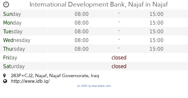
International Development Bank, Najaf
283P+CJ2
Bank
Finance
Point of interest
Establishment
read more
1.848 km
الحاجة ام وليد الفريجي ابو خلدون
X8P3+J6, Najaf
Post office
Finance
Point of interest
Establishment
read more
2.177 km
مكتب الدفان الحاج محمود شيخ محمد البصير الكعبي
2875+H78, Najaf
Post office
Finance
Point of interest
Establishment
read more
2.243 km
قبر حيدر محمدفهمي
2863+92P, Najaf
Post office
Finance
Point of interest
Establishment
read more
📑
all categories
Accounting
Airport
Amusement park
Aquarium
Art gallery
Atm
Bakery
Bank
Bar
Beauty salon
Bicycle store
Book store
Bowling alley
Bus station
Cafe
Campground
Car dealer
Car rental
Car repair
Car wash
Casino
Cemetery
Church
City hall
Clothing store
Convenience store
Courthouse
Dentist
Department store
Doctor
Electrician
Electronics store
Embassy
Establishment
Finance
Fire station
Florist
Food
Funeral home
Furniture store
Gas station
General contractor
Grocery or supermarket
Gym
Hair care
Hardware store
Health
Hindu Temple
Home goods store
Hospital
Insurance agency
Jewelry store
Laundry
Lawyer
Library
Liquor store
Local government office
Locality
Locksmith
Lodging
Meal delivery
Meal takeaway
Mosque
Movie theater
Moving company
Museum
Neighborhood
Night club
Painter
Park
Parking
Pet store
Pharmacy
Physiotherapist
Place of worship
Plumber
Point of interest
Police
Political
Post office
Premise
Real estate agency
Restaurant
Roofing contractor
Route
Rv park, camping
School
Shoe store
Shopping mall
Spa
Stadium
Storage
Store
Sublocality
Supermarket
Synagogue
Taxi stand
Train station
Transit station
Travel agency
University
Veterinary care
Zoo
sublocality level 1
↑