Establishment nearby شركة صيرفة
Iraq
Establishment nearby شركة صيرفة
شركة صيرفة
شارع المصطفى, An Nasiriyah, Nassriya, IQ Iraq
contacts phone
:
+964
Latitude:
31.0370529
, Longitude:
46.2387186
larger map & directions
read more
nearest Establishment
76 m
منفذ الوارث
26PQ+R64, Nasiriyah
Atm
Finance
Point of interest
Establishment
read more
410 m
Zamili Exchange Company 2
26MP+GJP, شارع المصطفى, An Nasiriyah
Bank
Finance
Point of interest
Establishment
read more
474 m
الدكتور امجد محمد فياض الياسري
26MM+QWJ, Nasiriyah
Dentist
Health
Point of interest
Establishment
read more
624 m
ATM
26RM+HVM, مصرف شارع الشيباني, بغداد
Atm
Finance
Point of interest
Establishment
read more
633 m
Bank of Baghdad
26RM+FMM, Nasiriyah
Bank
Finance
Point of interest
Establishment
read more
763 m
مركز الجود الصحي الخيري
مجمع تينا السكني, الناصرية
Dentist
Health
Point of interest
Establishment
read more
805 m
ربيتر الرايه
26MJ+4X, Nasiriyah
Post office
Finance
Point of interest
Establishment
read more
809 m
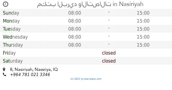
مكتب البريد والاتصالات
26MJ+J9W, 8, Nasiriyah
Post office
Finance
Point of interest
Establishment
read more
1.161 km
مقهى القيسي
26VX+M33, Nasiriyah
Cafe
Store
Point of interest
Food
Establishment
read more
1.204 km
مقهى ومطعم الاقتصاديين
26VX+GF2, شارع النهر, An Nasiriyah
Restaurant
Cafe
Food
Point of interest
Establishment
read more
1.264 km
شركة الشمس العلمية
26VX+QG5, Nasiriyah
Hospital
Health
Point of interest
Establishment
read more
1.274 km
د. محمد السعيدي
Nasiriyah
Dentist
Health
Point of interest
Establishment
read more
1.285 km
Andalus cafe
26WW+9X6, Nasiriyah
Cafe
Food
Store
Point of interest
Establishment
read more
1.287 km
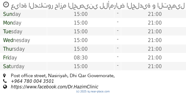
عيادة الدكتور حازم الحصيني للأمراض الجلدية و التجميل و الليزر
Post office street, Nasiriyah
Hospital
Hair care
Beauty salon
Doctor
Health
Point of interest
Establishment
read more
1.347 km
اف ام للتوصيل السريع 🚚
26HX+68R, Nasiriyah
Post office
Finance
Point of interest
Establishment
read more
📑
all categories
Accounting
Airport
Amusement park
Aquarium
Art gallery
Atm
Bakery
Bank
Bar
Beauty salon
Bicycle store
Book store
Bowling alley
Bus station
Cafe
Campground
Car dealer
Car rental
Car repair
Car wash
Casino
Cemetery
Church
City hall
Clothing store
Convenience store
Courthouse
Dentist
Department store
Doctor
Electrician
Electronics store
Embassy
Establishment
Finance
Fire station
Florist
Food
Funeral home
Furniture store
Gas station
General contractor
Grocery or supermarket
Gym
Hair care
Hardware store
Health
Hindu Temple
Home goods store
Hospital
Insurance agency
Jewelry store
Laundry
Lawyer
Library
Liquor store
Local government office
Locality
Locksmith
Lodging
Meal delivery
Meal takeaway
Mosque
Movie theater
Moving company
Museum
Neighborhood
Night club
Painter
Park
Parking
Pet store
Pharmacy
Physiotherapist
Place of worship
Plumber
Point of interest
Police
Political
Post office
Premise
Real estate agency
Restaurant
Roofing contractor
Route
Rv park, camping
School
Shoe store
Shopping mall
Spa
Stadium
Storage
Store
Sublocality
Supermarket
Synagogue
Taxi stand
Train station
Transit station
Travel agency
University
Veterinary care
Zoo
sublocality level 1
↑