Establishment nearby منظومة انترنيت الطالقاني
Iraq
Establishment nearby منظومة انترنيت الطالقاني
منظومة انترنيت الطالقاني
W8VC+C4, Al Jaliha, Al-Qādisiyyah Governorate, Iraq
contacts phone
:
+964
Latitude:
31.9435049
, Longitude:
45.3203721
larger map & directions
read more
nearest Establishment
14.429 km
شركه الماس الخير للخدمات التجاريه
365W+2W7, Afak
Post office
Finance
Point of interest
Establishment
read more
15.105 km
Rasheed Afak bank branch
368X+2F3, Afak
Bank
Finance
Point of interest
Establishment
read more
15.153 km
عيادة الزهراء البيطرية
366Q+79R, Afak
Post office
Finance
Point of interest
Establishment
read more
25.327 km
عمار المرجاني
443H+CM, Abu Yam
Dentist
Health
Point of interest
Establishment
read more
33.419 km
محمد آل جبر
P3CJ+CX5, الحمزة
Post office
Finance
Point of interest
Establishment
read more
37.165 km
وحدة البكتريا
XWHH+685, Al Diwaniyah
Hospital
Health
Point of interest
Establishment
read more
37.976 km
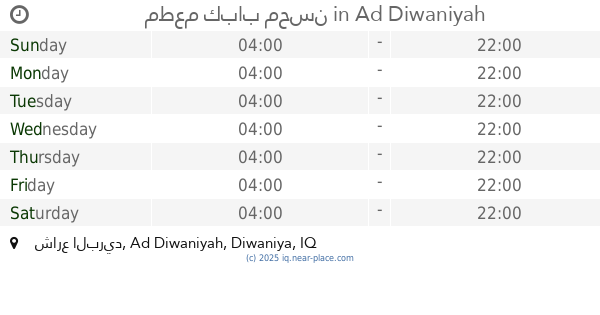
مطعم كباب محسن
XWMC+P7R, شارع البريد, Ad Diwaniyah
Restaurant
Food
Point of interest
Establishment
read more
38.929 km
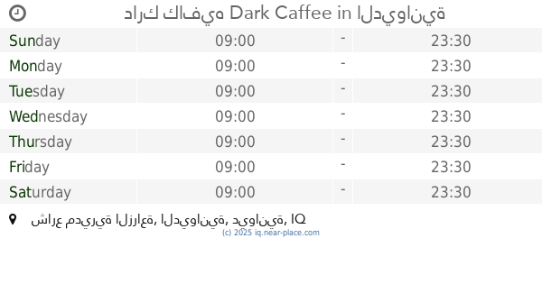
دارك كافيه Dark Caffee
XWM6+X7M, شارع مديرية الزراعة, الديوانية
Cafe
Store
Food
Point of interest
Establishment
read more
39.629 km
ابو يمان الخزاعي
XWG2+4R5, Al Diwaniyah
Lodging
Point of interest
Establishment
read more
39.748 km
اسواق بهاء
XWH2+393, Al Diwaniyah
Supermarket
Grocery or supermarket
Point of interest
Food
Store
Establishment
read more
39.794 km
اسواق علي حامد
XWP2+5QP, Al Diwaniyah
Supermarket
Grocery or supermarket
Food
Store
Point of interest
Establishment
read more
39.974 km
كوفي عبود لأمير
XV8X+X2V, طريق حلة - ديوانية, Ad Diwaniyah
Cafe
Food
Point of interest
Establishment
read more
40.198 km
مكتب المحامي حسين فائق
XVFW+J79, Al Diwaniyah
Post office
Finance
Point of interest
Establishment
read more
40.198 km
سيد رحمان
XVFW+J79, Al Diwaniyah
Restaurant
Point of interest
Food
Establishment
read more
41.135 km
محل ابو امير
XV7P+R26, Al Diwaniyah
Supermarket
Grocery or supermarket
Point of interest
Store
Food
Establishment
read more
📑
all categories
Accounting
Airport
Amusement park
Aquarium
Art gallery
Atm
Bakery
Bank
Bar
Beauty salon
Bicycle store
Book store
Bowling alley
Bus station
Cafe
Campground
Car dealer
Car rental
Car repair
Car wash
Casino
Cemetery
Church
City hall
Clothing store
Convenience store
Courthouse
Dentist
Department store
Doctor
Electrician
Electronics store
Embassy
Establishment
Finance
Fire station
Florist
Food
Funeral home
Furniture store
Gas station
General contractor
Grocery or supermarket
Gym
Hair care
Hardware store
Health
Hindu Temple
Home goods store
Hospital
Insurance agency
Jewelry store
Laundry
Lawyer
Library
Liquor store
Local government office
Locality
Locksmith
Lodging
Meal delivery
Meal takeaway
Mosque
Movie theater
Moving company
Museum
Neighborhood
Night club
Painter
Park
Parking
Pet store
Pharmacy
Physiotherapist
Place of worship
Plumber
Point of interest
Police
Political
Post office
Premise
Real estate agency
Restaurant
Roofing contractor
Route
Rv park, camping
School
Shoe store
Shopping mall
Spa
Stadium
Storage
Store
Sublocality
Supermarket
Synagogue
Taxi stand
Train station
Transit station
Travel agency
University
Veterinary care
Zoo
sublocality level 1
↑