Establishment nearby Essam house
Iraq
Establishment nearby Essam house
Essam house
2W6C+8H6, Al Diwaniyah, Al-Qādisiyyah Governorate, Iraq
contacts phone
:
+964
Latitude:
32.010656
, Longitude:
44.921758
larger map & directions
read more
nearest Establishment
533 m
تجاوزات القطاع الرابع
2W5G+FV5, Al Diwaniyah
Post office
Finance
Point of interest
Establishment
read more
618 m
مستشفى بغداد الاهلي
2W48+R77, Al Diwaniyah
Hospital
Health
Point of interest
Establishment
read more
709 m
AL-Diwaniyah General Hospital
2W47+GVX, Al Diwaniyah
Hospital
Health
Point of interest
Establishment
read more
715 m
وحدة العناية المركزة ICU
شارع النسر, الديوانية
Hospital
Health
Point of interest
Establishment
read more
737 m
بريد حي الفرات
2W67+HJJ, Al Diwaniyah
Post office
Finance
Point of interest
Establishment
read more
815 m
قسم الأمراض الانتقالية
2W47+GVX, Al Diwaniyah
Hospital
Health
Point of interest
Establishment
read more
831 m
عيادات ايبرو لطب وتجميل الأسنان
قرب صيدلية البدوية, الوكفة, Ad Diwaniyah
Dentist
Health
Point of interest
Establishment
read more
855 m
Digestive Center and Wholesale Neurological
2W57+67W, Al Diwaniyah
Hospital
Health
Point of interest
Establishment
read more
868 m
شعبة تفتيت الحصى وجراحة الجهاز البولي
2W47+HJC, Al Diwaniyah
Hospital
Health
Point of interest
Establishment
read more
904 m
الجملة العصبية
2W57+742, Al Diwaniyah
Hospital
Health
Point of interest
Establishment
read more
1.024 km
عيادة الحوراء لطب الاسنان
2W3G+3XF, Al Diwaniyah
Dentist
Health
Point of interest
Establishment
read more
1.178 km
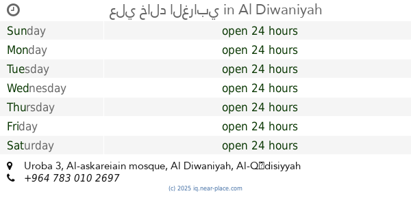
علي خالد الغرابي
Al-askareiain mosque, Uroba 3
Dentist
Health
Point of interest
Establishment
read more
1.895 km
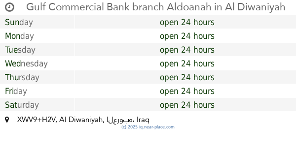
Gulf Commercial Bank branch Aldoanah
XWV9+H2V, Al Diwaniyah
Bank
Finance
Point of interest
Establishment
read more
2.071 km
مختبر الكندي للتحليلات المرضية
2W22+PX4, Unnamed Road, الديوانية
Hospital
Health
Point of interest
Establishment
read more
2.307 km
عيادات الدكتور عباس علي شرماهي الخزعلي
XWW3+CPW, Al Diwaniyah
Dentist
Health
Point of interest
Establishment
read more
📑
all categories
Accounting
Airport
Amusement park
Aquarium
Art gallery
Atm
Bakery
Bank
Bar
Beauty salon
Bicycle store
Book store
Bowling alley
Bus station
Cafe
Campground
Car dealer
Car rental
Car repair
Car wash
Casino
Cemetery
Church
City hall
Clothing store
Convenience store
Courthouse
Dentist
Department store
Doctor
Electrician
Electronics store
Embassy
Establishment
Finance
Fire station
Florist
Food
Funeral home
Furniture store
Gas station
General contractor
Grocery or supermarket
Gym
Hair care
Hardware store
Health
Hindu Temple
Home goods store
Hospital
Insurance agency
Jewelry store
Laundry
Lawyer
Library
Liquor store
Local government office
Locality
Locksmith
Lodging
Meal delivery
Meal takeaway
Mosque
Movie theater
Moving company
Museum
Neighborhood
Night club
Painter
Park
Parking
Pet store
Pharmacy
Physiotherapist
Place of worship
Plumber
Point of interest
Police
Political
Post office
Premise
Real estate agency
Restaurant
Roofing contractor
Route
Rv park, camping
School
Shoe store
Shopping mall
Spa
Stadium
Storage
Store
Sublocality
Supermarket
Synagogue
Taxi stand
Train station
Transit station
Travel agency
University
Veterinary care
Zoo
sublocality level 1
↑