Bank nearby Cihan Bank
Iraq
Bank nearby Cihan Bank
Cihan Bank
285R+JQH, Najaf, Najaf Governorate, Iraq
contacts phone
:
+964
Latitude:
32.0090691
, Longitude:
44.341998
larger map & directions
read more
nearest Bank
535 m
Syndicate Of Iraqi Teachers
285W+3XG, Najaf
Bank
Finance
Point of interest
Establishment
read more
805 m
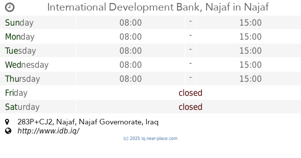
International Development Bank, Najaf
283P+CJ2
Bank
Finance
Point of interest
Establishment
read more
866 m
مصرف المشرق العربي الاسلامي في النجف
283P+4JF, Najaf
Bank
Finance
Point of interest
Establishment
read more
883 m
مصرف المتحد
282P+979, Najaf
Bank
Finance
Point of interest
Establishment
read more
910 m
مصرف الاستثمار العراقي النجف
282P+WJJ, Najaf
Bank
Point of interest
Finance
Establishment
read more
1.016 km
Gulf Commercial Bank / Najaf Branch
289R+7JP, Unnamed Road، الكوفة،, Najaf
Bank
Point of interest
Finance
Establishment
read more
1.164 km
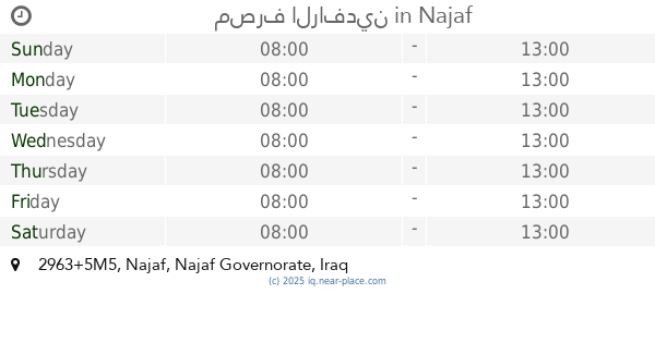
مصرف الرافدين
2963+5M5, Najaf
Bank
Point of interest
Finance
Establishment
read more
1.305 km
شركة الزلفى
2944+W73, شارع الروان, Kufa
Bank
Finance
Point of interest
Establishment
read more
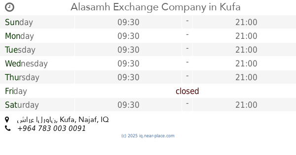
1.321 km
Alasamh Exchange Company
2944+R83, شارع الروان, Kufa
Bank
Finance
Point of interest
Establishment
read more
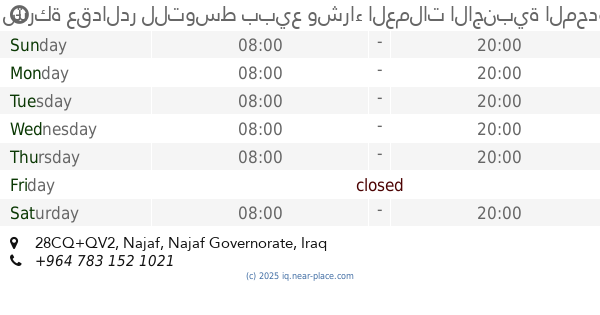
1.442 km
شركة عقدالدر للتوسط ببيع وشراء العملات الاجنبية المحدودة
28CQ+QV2, Najaf
Bank
Finance
Point of interest
Establishment
read more
1.502 km
National Bank of Iraq - Al-Najaf Branch
next to Sununu Restaurant, Al Rawan Street, النجف
Bank
Finance
Point of interest
Establishment
read more
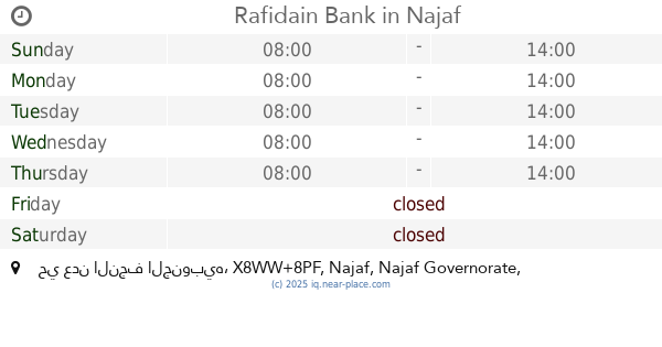
1.542 km
Rafidain Bank
X8WW+8PF, حي عدن النجف الجنوبيه, Najaf
Bank
Point of interest
Finance
Establishment
read more
1.783 km
Babylon Ahli Bank
X8WM+248, Najaf
Bank
Point of interest
Finance
Establishment
read more
2.063 km
شركة الياس للصرافة
X8VH+JJQ, شارع المدينة, Najaf
Bank
Finance
Point of interest
Establishment
read more
2.445 km
Agricultural Cooperative Bank
عمارة الحياة, Najaf
Bank
Finance
Point of interest
Establishment
read more
📑
all categories
Accounting
Airport
Amusement park
Aquarium
Art gallery
Atm
Bakery
Bank
Bar
Beauty salon
Bicycle store
Book store
Bowling alley
Bus station
Cafe
Campground
Car dealer
Car rental
Car repair
Car wash
Casino
Cemetery
Church
City hall
Clothing store
Convenience store
Courthouse
Dentist
Department store
Doctor
Electrician
Electronics store
Embassy
Establishment
Finance
Fire station
Florist
Food
Funeral home
Furniture store
Gas station
General contractor
Grocery or supermarket
Gym
Hair care
Hardware store
Health
Hindu Temple
Home goods store
Hospital
Insurance agency
Jewelry store
Laundry
Lawyer
Library
Liquor store
Local government office
Locality
Locksmith
Lodging
Meal delivery
Meal takeaway
Mosque
Movie theater
Moving company
Museum
Neighborhood
Night club
Painter
Park
Parking
Pet store
Pharmacy
Physiotherapist
Place of worship
Plumber
Point of interest
Police
Political
Post office
Premise
Real estate agency
Restaurant
Roofing contractor
Route
Rv park, camping
School
Shoe store
Shopping mall
Spa
Stadium
Storage
Store
Sublocality
Supermarket
Synagogue
Taxi stand
Train station
Transit station
Travel agency
University
Veterinary care
Zoo
sublocality level 1
↑